


.
| Murphy Family Ranch |
Murphy Family Ranch
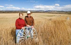
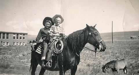
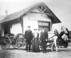
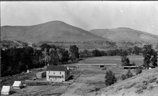
Article contributed by Tonya Bina of Sky Hi Daily News, October 2009 As late as this summer, John Murphy, 94, mowed ditches on his ranch land and built a new fence. "You got to keep busy doing something," he said.
|
| Murphy Ranch |
Murphy Ranch
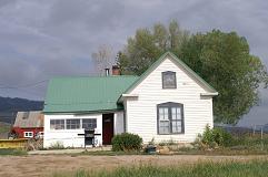
It's hard to imagine that there was a life before all the new homes filled in the spaces of the spacious lands around our towns. With all the high-tech innovations and new homes rising, ranch-life as it was in the late 1800's isn't thought about much. We're visiting today with John Murphy of the Murphy Ranch to capture some of the labors of ranch-living as he remembers it--before it is all too forgotten. The Murphy Ranch sits just outside of the Town of Granby and on a somewhat overcast morning, John Murphy is seen ambling down the road heading toward the cabin just above his log home where he enjoys life with his wife Carolyn. Driving next to him, I ask if he'd like a ride. "No", he said, "this is a good walk for me". In his hand he holds an electric bill that he is passing on to his tenant. He looks at the company car and asks, "Is that one of those hybrid cars?" I replied that it wasn't and he just shook his head. John with his gentle face sits with Carolyn on the sofa and begins the story of the Murphy Ranch. Jim and Margaret were the oldest Murphy siblings; John being the youngest. It wasn't uncommon to ride to school on horseback. John attended school in Granby where the apartments now stand across from the Community Building. In the winter, the horses would be stabled in a barn by the Trading Post (now Grand Mountain Trading). "On the ranch, we milked cows and sold cream," John said. "Mom sold a lot of butter too. She'd milk 5 gallons of cream and head to the depot. Most of the cream was shipped to Denver and Boulder. We had a well out back and Mom would store the butter in a bucket and put it down in the cold well-water. In the winter, we would saw off blocks of ice from the river and pack it in sawdust to store in the cold shed where we kept our meets. Meats were screened in. We raised goats for meat. Our first electric poles were set in 1942. Got all the poles in past the Barnard Ranch. Then the war started in 1945. Before we had electricity, we used kerosene lanterns. Mom loved to read and she read by the light of oil lamps. We used kerosene lanterns to milk the cows and the wind would often blow the flame out. With no bathroom facilities, you would have to use the outhouse in the middle of the night. We'd go to bed early because we had no lights. It was dark except for the oil lamps. Once we had electricity, we stayed up longer and read the Farmer's Almanac and Capper's Weekly. Every year we shipped 35 carloads of cattle to Omaha with cattle from Kremmling and North Park ranches (Linkes, Ainsleys, Sheriffs) and it was a big excitement for us. We'd ride in the caboose and travel back on the California Zephyr." After the war, Japanese families would live in colonies above the ranch. They helped harvest the lettuce fields. Lettuce was a big commodity and there were four packing plants set up on the riverbed. They shipped lettuce to Chicago, New York and Yuma, Arizona. They were hard working families. A lettuce warehouse was sitting where the Old Grand and Silver Spur Restaurant now sit. Lettuce was raised from Yampa to Tabernash in those early years. Suddenly, it disappeared because they found rust in the lettuce. Some say it was the soil. "Things were tough but we always had meat and potatoes. Never missed a meal. The only thing we didn't have was fresh fruit. At birthdays, we always had a special treat of concord grapes. A juice guy would come every few weeks. We'd love to see him, and he loved to see us-Mom always fed him." After the war, there were more responsibilities on the ranch. There was lots of physical, hard labor. Brother Jim was commissioner for two terms. John and his family have seen a lot over the years. Like many other ranchers, they have seen and experienced it all. Unlike today with all the modern conveniences, their lives were much different then and few today would know what it was like in those early years. Each ranch story is different in its way, but all have the same backbone---hard working families with a labor of love for ranch-life. |
| Ranching in Western Colorado |
Ranching in Western Colorado
Article contributed by Nichole Fuqua
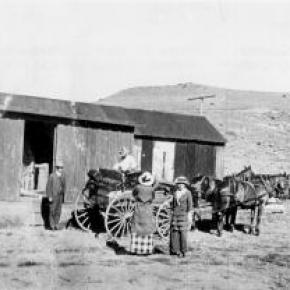
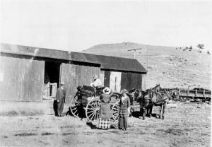
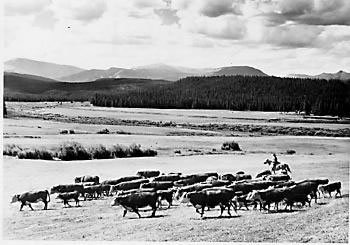
Ranching in western When cattle ranches first began, it was organized chaos. Up until the 1930's, all of the land used by cattle ranchers was open-range land. During the winter months the cows lived in the lower valleys where snow accumulation was small. Once spring began the cows were then rounded up and moved to the high mountain tops. This spring round up usually took place in the early part of June, between the first and second hay cutting. The main goal of the spring round up was to gather and sort all of the cattle into their respective herds; unfortunately many herds intermixed because of the open-range. Along with the sorting of the cows, the calves that had been born earlier that spring were branded. During the open-range era, brands on cattle were very important. Brands were used as a marker to distinguish between herds. Today, branding is still used along with ear tags. The fall round up usually began in the early fall and was completed in stages. The first stage, involved the gathering up of cows that were going to be sold at the market. These were the first to descend from the mountains. The rest of the cattle were then taken down from the mountain and released into the lower valleys to live during the winter months. The 1930's ended the open-range era which also brought an end to fall and spring round ups. Family life on a cattle ranch was very different from normal life in a town. The cowboy's job demanded a lot of devotion and self motivation. The men of the family were often away from the house for days sometimes weeks at a time moving and tending to the cows. The women of a cattle ranch lead very isolated lives. During the winter months traveling was unheard of. Once the snow began to melt the water's run off caused creeks and rivers to overflow, which caused traveling in the spring to be tough. During the summer and early fall, gardening, food processing, house keeping, raising children, and the general ranch duties kept a woman busy. The children of a cattle ranch were treated very maturely. By the age of five to the age of twelve kids were considered miniature adults. By the age of thirteen or fourteen most kids were able to perform heavy labor tasks around the farm. Ranch families exhibited very strict discipline toward the children of the house and felt very strongly in a child's education. Cattle ranches are still found all over western Sources: Reyher, Ken. High Country Cowboys. Montrose: Western Reflections Publishing Company, 2002. Peters, Aaron. Cattle Drives & Trail Drivers. 2003.
|
| The Davison Ranch |
The Davison Ranch
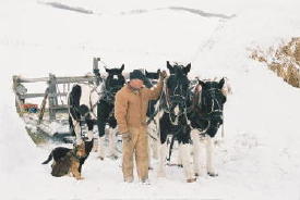
* Copyright 2006. Early morning, mid January in Colorado's Middle Park is not for the faint of heart. It's forty below zero. Six inches of new snow have fallen over night, adding to the three feet that have been building since early November. Ranchers in the area don't even bother to look at the breath taking beauty of the Gore Range to the West as they trudge to the barn. Their minds are focused on hope the big diesel tractors will start. Snow has to be moved and cattle fed. Life in these parts revolves around "feeding". Soon, ranch yards will be full of diesel engines belching black smoke clouds. Up and down U.S. Highway 40, this scene is repeated on ranch after ranch ... except for one. Just south of mile marker 169, a landmark rendered meaningless by snow much taller than the signpost, sets the Davison Ranch. Several hundred cattle wait semi-patiently to be fed in the surrounding meadows, yet there are no black smoke clouds or clattering engines. One might think the ranch deserted were it not for muffled sounds creeping through the huge log walls of the old tin roofed barn. Inside, a crew of five are performing a morning ritual that began in late November and will be repeated, regardless of the weather, seven days a week until mid May. Mark, Molly, Dolly, Nip and Tuck are getting ready to feed. A crew this small is rather unusual for a ranch that encompasses over 6,000 acres. More notable, only one member is a man. The other four are horses, big, stout, work hardened draft horses. Standing on the wooden planked floor, side by side, surrounded by logs a man could hardly put his arms around, are four beautiful black and white Spotted Draft Horses. While not rare, the National Spotted Draft Horse Association celebrated it's tenth anniversary in 2005, the spotted giants are not a common sight. It is fitting such unusual horses would be found on this ranch. The big black and whites fit right into a program in place nearly fifty years. Mark Davison relates the Davison Ranch history as he harnesses the big "Spots." Mark's father, Charles Edward "Tommy" Davison, had been saving to buy a ranch since he was six years old. When the old place north of Kremmling came up for sale, the young bachelor fulfilled his life long dream. Tommy made a few observations. The ranch did not produce gasoline for the old tractors that came with the ranch. It did grow grass to power the two long ignored draft horses, also included. Then, there was the snow to deal with. It seemed easier for horses to pull a sled full of hay on top of the snow than trying to drive a tractor through it. The ranch was strewn with old harness and equipment including an ancient hay sled and various hitch components. He was single with an old house to spend the winter nights in. Why not spend a little more time outside with the animals he so loved. Not all of Tommy's plans went according to schedule. The hay laddened sled required more horsepower than his two horses. Two more "kinda" draft horses joined them. The old log house burned to the ground in December that first year. Hurriedly, he built a small cabin to live in until another house could be constructed. In 1958 he met and married Laurayne Brown. The Kremmling native beauty was used to the harsh winters and loved the big horses. Tommy and Laurayne made as good a team as Nip and Beauty, one of the better teams they would own in those days. As the ranch grew they realized they needed more help. New Year's Day 1960 they interviewed a likely prospect. Jerry Nauta sat at the Davison kitchen table as they talked. Finally, he uttered memorable words. "If you treat me right," he said, "I will never leave this ranch." Addressing Laurayne he went on, "I will probably eat more meals at this dinner table than you will." Although the ranch owned several tractors as much work as possible was done with the horses. The ranch's hay crop, wonderful sweet smelling Meadow Brome, Timothy and Red Top was put into giant loose hay stacks. No need for big gas guzzling tractors pulling expensive balers on this ranch. A few other ranches also kept draft horses in those days. A big attraction at Kremmling's Middle Park Fair was the draft horse pull. Ranchers from neighboring North Park descended on the event with their horses, toughened by a summer of harvesting the Park's huge hay meadows. Most years they returned to their home valley with the Middle Park trophy. Tommy decided enough was enough. Even though he had never competed before, his team of the skittish Nip and gentle Beauty who scarcely knew a day out of harness, left the "invaders from the north" in their dust. The trio returned several more years, winning every single time. Finally, a bad referee's call moved another team into first place. Tommy, Nip and Beauty never entered again. It wasn't necessary. They had proven their point. During those years, money would sometimes be so tight the loyal employee Jerry couldn't be paid. Tommy would sign a promissory note to him for wages. He was always repaid, with interest. Tommy told friends, "Jerry is my banker!" Jerry became a third parent to the three boys born to Tommy and Laurayne, Matt, Mark and Cal. They joined the early morning harnessing ritual, standing on a milk stool to reach the big horses under this watchful eye. When their father suffered a broken leg followed by a ruptured appendix, the boys, averaging ten years old, stepped into rolls as hired men. They calved cows, lambed the ewes in residence on the ranch in those years and, of course, harnessed and drove the teams to feed. If harnessing and driving a four horse hitch wasn't enough of a challenge, the feeding process creates men as tough as the animals pulling the heavy sled. Up to three tons of long stemmed loose hay have to be pitched onto the sled. Once the feed grounds were reached, every single blade is forked onto the ground as the patient team slowly moves ahead of the hungry cattle. Most days three or more loads were required to complete the task. Tommy Davison fell ill in 2000. Mark who had remained involved in ranch operations while establishing another ranch in Wyoming, returned to the Kremmling ranch full time to oversee operations there. When Charles Edward Davison passed away in 2001, Mark leased the ranch from his family. Just as his father had done nearly fifty years ago, Mark took stock of what he had to work with. The harness, some nearly 100 years old purchased here and there over the years was in pretty good shape. The horses, however, had grown too old to be worked every day. He needed two more to complete his four horse hitch. Harley Troyer?s well known Colorado Draft Horse and Equipment Auction was coming up in Brighton, Colorado. Mark traveled to the "flat lands" and returned with two roan Belgium geldings. Sadly, one died within a year. He tried a "unicorn hitch" placing a single lead in front of the wheel team. It was not practical for the loads and trails they encountered. Mark headed back to Troyer's Auction once again. A novelty of the upcoming event was a pair of black and white Spotted Draft horses originating from Canada. When he arrived at the auction Davison found not two, but four of the Spots, two geldings and two mares. All were only two years old. To most, the big youngsters would need years of seasoning before they would be dependable. A lifetime spent around draft horses gave Mark Davison a different view.. He noticed how much time previous owners seemed to have spent with them. It showed in their responsiveness and manners. Auction owner Troyer remembers them as "A nice four up." When his gavel fell, all four were headed to Kremmling. Today, as nearly every day of the year, the wheel team of Nip on the left and Tuck to the right of the wooden tongue, follow the lead team of Molly and Dolly, left and right respectively. They begin pulling when Mark softly commands "gitup" and stop when told to "whoa-a." Armed with an antique True Temper three tine pitch fork (this model is no longer made according to Mark) he hardly notices their direction as he pitches hay to the trailing cattle. The scene is spell binding to anyone fortunate enough to see it. Soft commands, creaking leather and steel clad wooden sled runners gliding over the snow summon long forgotten instincts. Though Mark describes himself as a "Dinosaur," all that happens on the Davison Ranch is part of a plan that arose from necessity. He points out that when hitched to the sled, only the wheel team is attached to the tongue. The lead team's evener, an antique itself, is attached to a log chain r nning back to the front of the sled, not attached to the tongue in anyway. Tight corners the team must navigate winding into the mountains to feed the cow herd make a conventional arrangement dangerous. If the wheel team follows the lead teams tracks too closely, the sled would cut the corner and plunge off the precarious road. The loose chain arrangement allows both sets of horses freedom to follow their own path. The horses, sensing their safety as the reason for the odd arrangement, work quietly beside the chain. If one happens to step over it, the next step will be back into place without so much as a twitch of an ear. Feeding begins around 8:00 a.m. The teams are usually back in their stalls eating "lunch" by 2:00 p.m. Six hours, eight tons of hay and nearly ten miles every single day make the horses tough and strong. They symbolize the word that describes life on the Davison Ranch. Harmony. The horses work in harmony with each other and their care taker. Horses and man work in harmony with nature. There is a strong respect for tradition on the Davison Ranch. The old ways made sense then and now. There is no need for electric engine heaters or big diesel engines on this ranch. The beautiful black and white horses seem to be thankful for the chance to live the life for which they were bred. They express their gratitude with loyalty to Mark Davison. Loyalty might also be used to describe the Davison Ranch business plan. Remember Jerry Nauta's pledge to never leave the ranch if they treated him right? Jerry lived in the small cabin Tommy Davison built when the ranch house burned down from January 1, 1960 until a few months before his death in July 2005. He was 92 years old. Life is different on the Davison Ranch. Old fashioned values reign amidst modern Spotted versions of man's first and perhaps best machinery, the draft horse. Men and horses are a lot alike, you know. Treat 'em right and they'll reward you with loyalty. |


 ,
,  ,
,