Joe on Melody

Places Articles

Williams Fork Reservoir

Article contributed by Liz Church


Williams Fork Reservoir plays an important role in water conservation, while being an asset in revealing archaeological data of earlier existent peoples in the region. The reservoir is located about 12 miles southeast of Kremmling at an elevation of 7874 ft. in Grand County, Colorado, near the center of Middle Park. Williams Fork is a tributary of the Colorado River, extending from Clear Creek to Vasquez Creek, with the Vasquez Tunnel running through and its completion in 1959.


Williams Fork is a water source to the Denver Metro Area, with diverted water from high elevation tributaries of the Williams Fork River to the Gumlick Tunnel for departure to the Moffat Tunnel system. Standing 217 feet above the Williams Fork River streambed, the dam backs up a reservoir of 97,000 acre feet of water.


Williams Fork is also a Paleo-Indian site.  Archaeologists believe that 12,000 years ago, during the last Ice Age, people migrated from Asia into North America. Most Paleo-Indian sites are identified by an existence of projectile points. The Williams Fork Reservoir was dominated by James Allen projectile points, a categorized set of points, or better known as a categorized set of stone tools. The reservoir allows archaeologists to access the extent in which the James Allen points and perhaps earlier existent groups were bestowing the mountains during the Holocene period, the name given to the last 10,000 years of the Earth's history.


Source: http://en.wikipedia.org/wiki/Phillips-Williams_Fork_Reservoir _Site


Winter Park
Winter Park

The town of Winter Park was first settled in 1923 and incorporated in 1978. It came into existence as a construction camp during the building of the Moffat Tunnel. The west portal is located here, hence the original name of West Portal.

As early as 1929 hearty winter sports enthusiasts were getting off the regularly scheduled trains there to ski the trails that were being developed. Regular weekend service on a special ski train began in January 1938. That same year, the U.S. Forest Service gave permission to the City and County of Denver to develop land near West Portal for winter sports, constructing ski-tows and trails. Winter Park ski area was formally opened in 1940.

With the consent of postal authorities, West Portal’s name was changed to Winter Park to publicize the ski area.  Benjamin F. Stapleton, the mayor of Denver at the time, championed the cause of the name change to help publicize the winter sports of the area. The town has now grown into a classic resort town and the ski area management has been recently turned over to the Intrawest Corporation by the City and County of Denver.

Articles to Browse

Smiths of the Blue River

Frank John Smith was born October 5, 1852 in Granby, New York.  He married Elizabeth Olive Sanders, who was born in 1860 in Hannibal, New York.  They were married in 1878 in Hannibal and had two children Albert and Lelah.  Albert died as an infant in 1881.  In 1880 Frank homesteaded his ranch close to the Blue River and sent for his wife and baby daughter who came West by train to Dillon in the spring of 1883.

They had 10 more children, all born at the Smith Ranch, between 1884 and 1907.  As the boys grew into young men, they homesteaded additional acreage around the ranch.  The youngest son, Earl, operated the Smith Ranch until 1958, when it was sold to Ted Orr Sr. His son, Ted Orr Jr. and his wife, Virginia Smith (granddaughter of Frank and Elizabeth) operated the ranch until 1967, when it was sold to the Berger brothers.    

Topic: True Crime

Spider House Tragedy

Nestled on a quiet lane in Old Grand Lake City sits the intricately crafted home of Warren C. and Mary O’Brien Gregg, known today as the Spider House – a testament to a remarkable woodcraftsman and his tormented wife.

Warren (Watt to his friends) was a dreamer and in the 1870s he left his first wife and a young son in Wisconsin and headed for the Colorado Territory seeking his fortune in the mines of Gilpin County.  Upon returning to Wisconsin his first wife died of fever, leaving Warren a widower with a small son.  Holding tight to his dreams of the west, Warren eventually ended up in his native Indiana where he met and married 20 year-old Mary O’Brien, in 1884.   By 1888 Warren packed his new family into a prairie schooner and headed west.  Like so many other pioneer women before her, Mary bore a child along the trail, a second son whose short life would send Mary down a dark and tortured path. 

The family arrived in Middle Park late in the summer of 1888, built a small homestead on the eastern slope of the Stillwater drainage and the newborn died shortly thereafter.  Though the years would bring more children, Mary would never quite recover from the loss of her second son. They continued to scratch out a living in this harsh and isolated land, where winters were long and supplies were meager. 

Warren spent much of his time searching for game and exploring this new country. The Gregg’s moved numerous times, finally purchasing a plot of land from Old Judge Wescott on the west side of the lake.  Warren built his family an admirable house, with intricate detail and spider-like webs of wooden elements.  Despite the warmth and comfort of this new home, and the close proximity of neighbors, Mary’s depression deepened. 

Then on a sunny Sunday in 1904, while Warren was working in his woodshop and oldest son Lloyd was having Sunday dinner at Judge Westcott’s, Mary took a gun to her four remaining children and then turned the weapon on herself.  The children died instantly while Mary lingered on for four days.  The five victims of this tragedy, one girl, three boys and Mary herself are buried together in one grave in the Grand Lake Cemetery.

Warren lived in the Spider House for another 29 years. With his son Lloyd, he continued building homes and stone fireplaces.  He succumbed to heart failure in 1933.  Mary O’Brien Gregg finally found peace in the quiet grace of the little town cemetery surrounded by her children.  Almost a century later, as the tall pines whisper their mournful winter song, the Spider House still sits nestled on that quiet little lane.

Topic: Regions

The Troublesome

Tradition holds that an army party led by one Lt. Col Johns gave the name of Troublesome to what had sometimes been called Oties Creek.  The Army was plotting a road in 1865 and had to go north to the forks of the East and West Troublesome in order to cross it, because of the soft soil, thereby being a “troublesome” creek.  Some historians claim that mountain man “Colorado Charley” Utter had built a cabin on the creek in 1861, which became a popular stopping place for early hunters and trappers in the region.  Another report credits John S. Jones of Empire with a cabin near the mouth of the Blue River, a few miles away, that same year.

Among the earliest settlers on the Troublesome were Barney Day, Henry King and Martin “Dock” McQueary, who had a cabin there in 1871.  In 1878, a post office was established at the King home. 

By the end of the century, many ranches had been established at on Troublesome Creek.  Farthest upstream was the remote George Hendricks ranch, difficult to reach year round and totally cut off from the rest of the world during winter snow.  Mrs. Hendricks had a large library and gave her children a sound education prior to their high school years in Kremmling. 

Among the most prominent ranches were those of George and Forrest Wheatly.  Probably the largest ranch (3000 acres) was that of the family of Con Ritschard, lying just north of current day U.S. Highway 40 east of Troublesome Creek.

Life was hard for the settlers in the area.  Like much of Grand County, the soil was frozen as deep as eight feet in the winter.  One memoir noted that when there was a death in the winter, the corpse was placed in the roof of a cabin, well swathed, until the spring thaw allowed for permanent burial.

There was a six year school (second to seventh grade) and a post office established at Pearmont about half way up the Troublesome, in the 1920s.  This area was named for local settler Gus Pearson.

Ranching was not the only pursuit along the Troublesome Creek.  Settler Roy Polhamos grew lettuce and shipped it through the Granby Cooperative to Denver.  He also had a potato contract with one of the Denver grocers.  Other growers contributed to the 125 refrigerated train carloads of lettuce that were shipped from Granby in 1924.  By 1929, 34 farmed from Granby to Troublesome netted $46,000, a highly respectable profit in those days.

Topic: Towns

Radium

The settlement of Radium, on the north bank of the Colorado River in Gore Canyon, was established in 1906, when railroad construction of the Denver and Salt Lake Railroad brought in foreign workers, typically Swedes, Greeks, and Italians. After the rail lines were built, livestock was shipped out and vegetables such as potatoes, peas, and lettuce were grown and picked at the last minute so they could be shipped while still fresh.

Originally the land was homesteaded by the Murgrage and Hoyt ranch families. Railroad passenger service during the winter months was scheduled only three times a week each way but even then, couldn’t always get through. Nonetheless, the “Try Weakly Railroad” service was better transportation than anything residents had ever had before.

The name of Radium was suggested by Harry S. Porter because of the radioactivity found in his mine. The nearby Radium Copper Mine was a large copper producer at one time.

Maintainance workers for Union Pacific, current owners of the railroad, are still based at Radium.

Topic: Towns

Monarch & KaRose

Once upon a time on the land that lies beneath Lake Granby and Shadow Mountain Lake there were ranches, pastures and an almost forgotten town, Monarch.  It is a story that goes back 100 years to the Summer of 1905, and the arrival of train service in Middle Park and promoters who were "honest men, but too visionary and lacking in experience", according to Frank H. Wolcott, a brother of one of the founders.

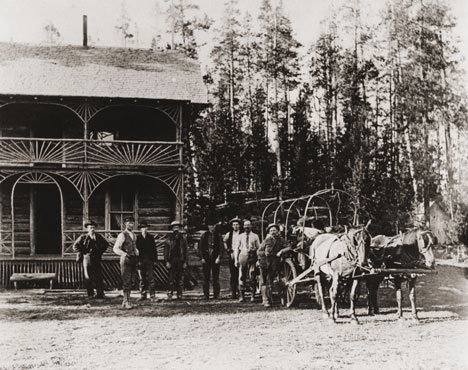
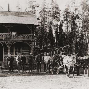
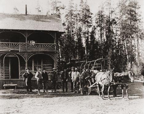
The Monarch Consolidated Gold and Copper Mining and Smelting Company owned the King and Queen copper mines on Arapahoe Range above the South Fork of the Colorado River.  They felt their assays indicated ore worthy of a mill and arranged to haul in the heavy machinery and proceeded to build a town with cottages, a small hotel, stores, a bowling alley, theater and dance hall.  By 1907 Monarch had a school and post office.  However, records indicate only about $150 worth of copper per year was ever produced.    

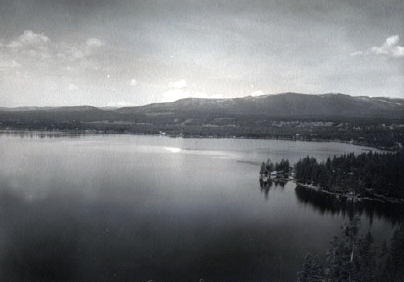
Soon the promoters realized a sawmill was needed to provide both timber and cash to support the mine operation. A dam was built creating Monarch Lake at the junction of Arapahoe Creek and the South Fork of the Colorado, and a canal was built to float logs cut near Strawberry Lake to Monarch Lake.  A stern wheel steamer bunted rafts of logs into flumes and canals towards the sawmill downstream in Monarch.

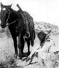
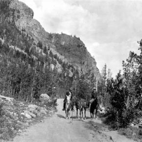
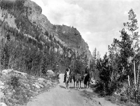
In the spring of 1906, Monarch management obtained a charter to build the Rocky Mountain Railway, a standard gauge, for lumber and passengers, from the Moffat tracks in Granby to Grand Lake, with a spur over an unspecified pass to Walden, in North Park.  The track was laid following the river from Granby to the sawmill, by Japanese and eastern European laborers.  Ranchers along the route, excepting Fred and Frank Selak, quietly granted rights-of way. The only rolling stock owned by the railroad was a small, ancient locomotive and a caboose.  The night before Thanksgiving 1906 the first train rolled into Monarch, and the rails never extended any farther.  There was daily service, and local ranchers could flag a ride or have their packages dropped off.  There were no cattle guards, so the fireman would step off the locomotive, open a ranch gate, and close the gate and hop back on after the train passed through. 

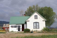
During the winter of 1905-06 a box factory was started. It operated briefly before it was destroyed by fire in the fall of 1908.  The fire forced the mill and railroad into receivership.  Visitors, particularly former stockholders, helped themselves to equipment and entire buildings, but Monarch's core was preserved and developed by Harry L. Dierks of Kansas City into KaRose.  This summer resort was named in honor of Dierks' daughter Katharine Rose.  Other Monarch buildings went to neighboring dude ranches and the bowling alley went to Granby.  

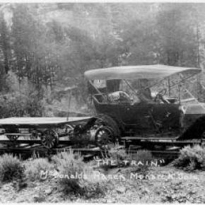
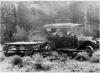
To hold the railroad right-of-way, Ernest Behr restored the locomotive in 1912 to carry parties of fishermen along the river from one pool to another.  Ed McDonald, a dude rancher, ran a Cadillac touring car on flanged wheels on the rails to carry mail, supplies, and passengers to the valley ranches.  Just before World War I the engine and rails were sold for scrap. 

Frank H. Wolcott wrote, "In September 1954 my wife and I drove over the site to discover any signs of Monarch or the railroad...It gave us a queer feeling to realize that substantial things like railroads and buildings that we helped build have vanished.  Was it all a dream?"

Topic: Granby

Historic Granby Real Estate

William Shakespeare, the historic play writer, said, “There is a history in all men’s lives.” The same could be said for many Grand County buildings. According to author, Lela McQueary in her 1962 book, “Widening Trails,” real estate sales and land giveaways helped to build our towns. “In 1905, a town site was obtained from Jim Snider, who had homesteaded the land upon the sagebrush mesa,” wrote McQueary. “The village was called Granby for Granby Hillyer, a civil engineer. Two general stores, two livery stables, a post office and a tiny café (all built with false fronts to make them appear much larger) were scattered on the north side of Main Street, three blocks long.”  That Main Street today is Agate Avenue. A quick search of the Grand County tax rolls reveals an interesting historic mix of buildings.

For example, the current Brynoff home at 170 2nd Street was the Post Office building constructed in 1910 and originally located at 458 East Agate. That building was moved to its current home to make way for the construction for the new Post Office building in 1945 at 458 East Agate. Deb Brynoff, the Executive Director of the Grand County Board of Realtors, said, “When we updated and built onto the original building, we found old letters stuffed in the walls. Obviously, they used them in the early years to add insulating value. I guess they had junk mail even then!”

On July 1, 1966, a new Post Office building was dedicated at 225 East Jasper Avenue (now the current home of the Grand County Library District Administrative Office). According to Granby-area Realtor, Susie Peterson of Glenn Realty, who used to own the building at 458 East Agate when they converted it to the Granby Veterinary Clinic, “Downstairs was full of those neat glass front post office boxes with the gold dials. You can just imagine the history in that building.”  Other buildings constructed in those early years were 127 4th Street in 1909. In addition to a private home, over the years, businesses such as Re/max Real Estate and Katie’s Flower Shop were located at 247 East Agate, which was also built in 1909. In 1910, the property at 110 Garnet was built.
The Roaring 20s saw a spurt of construction such as 172 Topaz (1922), 307 Jasper and 59 4th Street (1924), 166 Jasper and 291 Topaz (1929). The current Columbine Café property at 395 East Agate was built during the heydays of 1927 when it was called the Town Crier Restaurant.

After the Great Crash of 1929 and the Depression of the 1930s, New Deal jobs and loan programs helped fuel new construction. In fact, in 1933, the famous Payne’s Café was built at 365 East Agate. Today, the Greater Granby Chamber of Commerce and Downtown Enhancement offices, along with Noriyuki & Parker law offices are housed in the almost 75 year-old building.

Today’s Shadow Mountain Chiropractic Clinic of Drs. Jeff and Deb Shaw at 60 2nd was built in 1935 as a private home. On April 18, 1935, the first addition to Granby helped the town grow. In 1938, 387 East Agate was the site of the new pool hall run by Alva West. Today Lorene Linke’s Fabric Nook welcomes customers and quilters at the historic location.

In 1938, the building at 185 East Agate, which was Granby’s first strip mall, also was constructed with Craig’s Café, later Olson’s Café. Over the years businesses such as Maureen’s Clothing Shop, a laundromat, a barbershop and the Carpet Wagon found homes where today the Longbranch and Schatzis Pasta & Pizza Restaurants are found.

Post World War II America and Granby boomed. Granby had an influx of new residents because of the continued construction of the Granby Dam and the Colorado Big Thompson Water Project. In 1946, the Granby Dairy Building at 106 Jasper sprung up. That same year, Carmichael Real Estate Company built a new office at 191 East Agate. Today real estate is still king at that corner building with the Grand County Board of Realtors and The Title Company of the Rockies offices located there.

The Granby landmark, Frontier Motel, at 232 West Agate was built in 1951 by Earl Saylor. In 1954 Jenkins & Fulk began construction of the Granby Trading Post at 231 East Agate. Ken and Debbie Eaker and Jay Young bought that property in May 1995 and renamed the store, The Grand Mountain Trading Company.  

Topic:

Places in Grand County

Click on the drop-down menus and discover the history behind some of the everyday places you visit in Grand County.

Grand County was established in 1874 by the Territory of Colorado, thus becoming a county two years before Colorado became a state. It was named for the Grand River, the name by which the Colorado River was known at that time. 

The headwaters of the today's
Colorado River are in Grand County. The county was formed from a portion of Summit County but acquired its current boundaries in 1877, when part of the Grand County was used to create Routt County.

The county seat is Hot Sulphur Springs. The area of 1,854 square miles (larger than Rhode Island) consists of meadows, river valleys and mountains.

Sources:
R.C. Black,
Island in the Rockies. Pruett Publishing Company, 1969
William Bright,

Colorado Place
Names. Johnson Publishing Company, 1993
Hafen and Hafen, Our State:
Colorado. Old West Publishing Company, 1971

Topic: Grand County

Grand County Time Line

Prehistoric
7000 BCE to 900 BCE: Paleo Indians  (Yarmony, Rollins Pass, Windy Gap) use Middle Park as summer hunting area

1819 – 1860
1819:Adams-Onis Treaty – Middle Park partitioned – Sites of Granby, Fraser, Grand Lake and Hot Sulphur are in the U.S, Kremmling still part of Spain

Middle Park well known to “Mountain Men” by 1820

1828: Kremmling becomes part of Texas

1837: T.J. Farnham’s expedition crosses the Blue at Grand River

1839: Grand River named on a semi-official map

1842: Rufus B. Sage visit

1844: Captain John C. Fremont’s second expedition, accompanied by Kit Carson, enters Middle Park over Muddy Pass and exits up the Blue River

1854: Sir St. George Gore, an Englishmen, accompanied by Jim Bridger enters Middle Park for hunting expedition

1859: First appearance of prospectors; interest in Hot Sulphur Springs

1861 – 1874
1861: Berthoud crosses Berthoud Pass and traverses Middle Park

1861: Middle Park becomes part of Summit County

1863: Trouble begins between the Utes and white men

1864-1868: Wm. N. Byers acquires Hot Sulphur Springs

1866: Gov. Cummings signs Treaty of Middle Park

1868: John Wesley Powell visits Grand Lake, makes first recorded ascent of Longs Peak

1867: Joseph Westcott settles at Grand Lake

1871-1872: Clarence King surveys area

1873-1874:  F.V. Hayden surveys area

1874: Creation of Grand County (two years before Colorado became a state)

1874: Toll roads opens over Rollins and Berthoud Passes

1874: William H. Jackson, renowned photographer, takes first photographs of Middle Park

1875 – 1888
1875: First mail routes to Hot Sulphur Springs

1875: Silver ore indications in Never Summer Range

1875: First school opens in Hot Sulphur Springs with 12 students, (school “year” was 20 days)

1877: Routt County detached from Grand County

1877: Stokes-Dean political crisis

1878: Tabernash and Abraham Elliott killed

1879: Ute Indian War produces excitement, anxiety

1879: Lulu City & Teller City formed

1880: Gaskill City formed

1881: Four railroad projects frustrated

1881: County Seat moves to Grand Lake, height of mining boom,   Grand Lake Prospector is launched

1883: Commissioner shootings at Grand Lake

1884: Shooting of Texas Charlie in Hot Sulphur Springs

1884: Kremmling formed

1885: Kremmling Post Office opens

1885-1886: Collapse of mining, North Park separates from Grand County

1888: County Seat moves back to Hot Sulphur Springs

1889 – 1904
Expansion of ranching

Development of public education

1890: Grand Ditch construction begins... carries water from Grand Lake mountains to the front range

1891: First platting of Kremmling

1891: Berthoud Pass route becomes state road

1893: Construction begins on Byers Canyon road

1896 et seq.: Organized religious congregations develop

1892: First diversion of water to eastern slope

1898: First high school opens in Kremmling

1902-1904:  Moffat – Harriman struggle

1903: Hot Sulphur Springs incorporates

1904: Kremmling incorporates

1904: Moffat Road crosses Rollins Pass

1904: First motor car arrives Grand County

1904: First telephones installed

1905 – 1914
1905: First Forest Reserves

1905: Fraser develops, Granby is founded

1905: Moffat Road reaches Hot Sulphur Springs

1905: Parshall is founded

1906: Moffat Road reaches Kremmling

Proliferation of competitive newspapers

1905-1908: Heyday of Monarch

1908: Arapaho National Forest established

1911: First Hot Sulphur Springs Winter Carnival

1912: First Middle Park Fair

1913: Eleven motor vehicles are registered in Grand County

1913: Tabernash established as railroad division point

1915 – 1930
1915: Rocky Mountain National Park founded

1917-1918: Participation in World War I by 151 Grand County residents

1918-1919: Influenza epidemic

1919: Grand County Pioneer Society founded

1919: Fall River Road completed

1921: Grand River name changed to Colorado River by U.S. Congress

1922: First radio receiver

1923: Gore Pass opens to motor vehicles

1923: Improved Berthoud Pass road opens

1923-1928: Moffat Tunnel built

1926: Fred Selak murder

1929-1941: The Great Depression

1930-1932: Berthoud kept open all winter

1932: Trail Ridge Road completed

Since 1930
1938: Colorado-Big Thompson irrigation and power project begins

1940: Winter Park Ski Area opens

1941-1945: Participation in WWII

Late 1940s – early 1950s: Construction of Colorado– Big Thompson Project

1947: Adams Tunnel in operation

Growth, then boom, of winter sports


Topic: Grand County

Grand County Trivia

After 1879 there were no Native Americans in Grand County.

In the 1800, the leading cause of death in Grand County was accidents followed by pneumonia.

Between 1887 and 1902, Grand County had no divorces.

The total resident population of Grand County in 1900 was 741.  The average life expectancy was 47 years.

Winters in Grand County often were severe, but nothing as terrible as the winter of 1898-1899.  Warm weather preceded the storm which began on February 2nd.  Four feet of snow fell by that first evening and the residents did not see the sun for the rest of the month as the snow continued to fall.  The snow continued into March and April and while few residents died, but the loss of livestock was tremendous.

Topic: True Crime

The face of the 1883 Grand Lake Commissioner Shooting

By Amy Ackman Project Archaeologist - 2018

I work in Cultural Resource Management (CRM), which means I document any man-made occurrence that is 50 years or older. I’ve recorded anything from prehistoric stone tools to 1940’s cans and glass. As a CRM archaeologist, I’m a data collector. Our job is to protect the archaeological record by gathering data and determining the significance of it.  In 2011, I worked on a project near Jensen, Utah, just across the border from Colorado. During this project, I came across an unmarked grave. There was a headstone, but no name. I eventually found from historical documentation that the grave was that of a man named William Redman.

Redman was the undersheriff who took part in the Grand County Shooting of 1883 that involved three county commissioners, a county clerk, and the sheriff. Three men died during the shootout, two men died of their injuries after the fact, and the sheriff committed suicide out of guilt. Two weeks after the incident, Redman was the only living participant. He was on the run from the law and actively hunted by the Rocky Mountain Detective Association. A full month after the shootout, Redman was found dead in Utah at the side of a road with a bullet in his head.   

I knew Redman was part of the Grand County Shooting and poured over any sources I could get my hands on; books, websites, newspaper articles; any tidbits of information that might answer questions. Like a detective, I wanted to understand how Bill Redman was involved in the gunfight and how he ended up in Utah.  I found the story and a picture of William Redman and I was ecstatic that a site I had recorded was associated with such a tale.

William Redman was ruggedly handsome with high cheek bones and pronounced jaw; the clothes and countenance of a miner. The more I learned about him, the more questions I had. How old was he when the photo was taken? At a time when it was such a privilege to have a photo taken, why is there a photo of him and not other prominent men in the county? I wondered about his motivations. Was he the ruffian newspaper articles touted him to be?  Archaeology is about understanding the past. Most of the time we are forced to interpret the past with only a few pieces of material that are left behind. The more material and data we have, the more we can understand.

In the case of William Redman, there are questions surrounding his death that give rise to the possibility that the man in the grave is not Redman at all. If the opportunity arises to excavate the grave, his photograph will assist in his identification.  Archaeology not only studies the past but works to preserve the past for the future. Now, I hope that a family member of yours is never being researched by an archaeologist for being a ruffian and a murderer. But, like an archaeologist, I would encourage you to preserve as much as possible for those in the future who would care to learn about the past.

Error message

  • Notice: Undefined index: quantity in omega_views_mini_pager() (line 234 of /var/www/html/docroot/sites/all/themes/omega/omega/inc/theme.inc).
  • Notice: Undefined index: quantity in omega_views_mini_pager() (line 234 of /var/www/html/docroot/sites/all/themes/omega/omega/inc/theme.inc).

Places