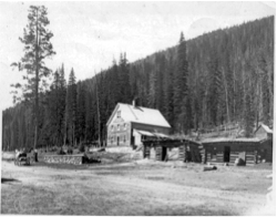
You gotta love a mystery! My curiosity rose, my anticipation of being the one with the real story was more than my appetite could stand. I looked at pictures, figured angles, mused at what other people said, reviewed topographic maps and finally said to myself “it just can’t be.” The terrain doesn’t look like that. It isn’t two miles from the last switchback on Hwy 40. I don’t care what the writing on the back of the pictures say.
I want to know once and for all, where is the real location of Spruce Lodge? How can it be located so everyone will agree. I’ve got it, find an expert wilderness person with my same curiosity. As fate would have it, entered Debora Carr, author of Hiking Grand County Colorado, complete with pictures, maps, GPS coordinates and trail narratives. Her coauthor Lou Ladrigan also caught the bug. “We can find it.”
Exploration began early in the spring but the snow was just a little too deep to find any artifacts. Failed attempt, but the appetite was there. Wait till the snow melts in the trees. Again, as fate would have it, entered Carol Hunter. Carol has been instrumental in the efforts to resore the Berthoud Pass wagon road. Carol has lots of maps and pictures of the development of the wagon road and just happened to have an original U.S. Bureau of Public Roads 1920 survey map for the construction of Hwy 40 from Empire to Fraser. I loaded it into the computer, expanded the image and found lots of strange numbers. Almost like mile markers. Carol said they were numbers used by the work parties. They seemed evenly spaced and the map had a distance legend. It even had a marked location for Spruce Lodge. I couldn’t wait to add this map to Deborah and Lou’s reference material.
Armed with new references, Debora and Lou hiked both sides of Hwy 40 from the switchback to the entrance to Mary Jane. Looking for artifacts, existence of remnants of the old wagon road, foundations and terrain that matched the photos in the GCHA collection. A couple places looked promising, but not quite. Finally, a white station post number 390 was found lying on the ground on the west side of today’s Hwy 40. Then another white station post was found to the south, number 380. That was a match! Just what we needed. That confirmed the surveyor L.J. Young’s map. To the south of 390 a flat part of ground revealed what looked like part of a foundation and surrounding the location were remnants of discarded cans and possible buildings. A two holer! Now check the terrain with the pictures. Well maybe. Don’t forget that Hwy 40 didn’t exist. Step back and look from the east side of the existing Hwy. A great match with the slope and tree line. This was it! Just .9 miles North of the last switchback.


