Winter Park Ski Shop

Community Life

What was it like to live in Grand County in the 1800's or the early 1900's? .

Community Life Articles

2006-100 Year is Here

Poem, contributed by Vera Shay, August 2006


Since the railroad tracks

Were all laid down

Trains coming into Kremmling town

Only books, left to tell and say

Of the excitement that day

Of the thirties and the forties

It is so

Of the railroad tracks and trains

I do know

I rode on them everywhere

Here and there

During those years in my mind

I owned them all you see

That I would have told you

Had you asked me.

Todays trains all have a brand new look

Inside and out

Riding on the trains from them till now

There is no doubt

The train crew and passengers of today

Still just as fun and great

Though they seem to always be running late

Lots of folks think they're just too slow

For me they've always been

A wonderful way to go

Trains, trains

Let there always be trains


4th of July Parades in Granby
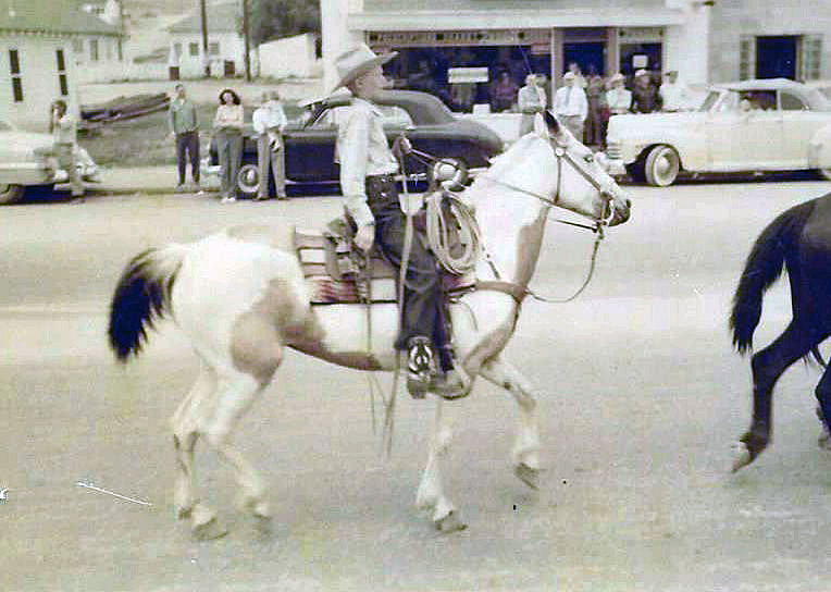
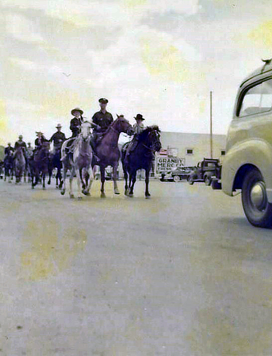
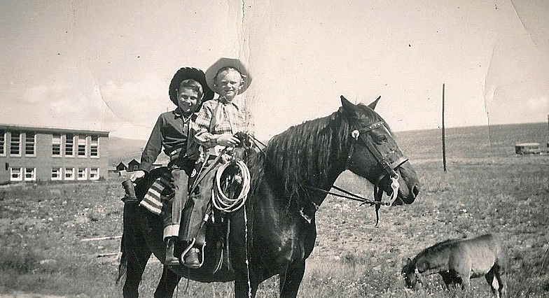
Joe on Melody, Joe and Dad in 4th of July Parade, Joe and Howard 4th of July Parade

In 1947 my family moved to Granby, Colorado; I was 5 years old. My Mom (Eloise) and Dad (Howard, “RED”) Beakey, ran the Texaco gas station where the Chamber of Commerce parking lot now sits. I have a sister named Sandra Sue, who was 3 at the time.

In 1948 Mom and Dad bought me a mare named Midge, and that is the beginning of my joy of growing up in Granby. I rode Midge all over Granby and surrounding area. In the winter I would pull kids on their sleds and skis with a rope tied to the saddle horn. In the spring of 1949 Midge produced a filly foal that we named “Lady Blaze.” The following 4th of July Rodeo Parade, 1949, I rode on Midge and my friend, Howard Ferguson, rode behind me and led Lady Blaze in the parade. A local farrier had made lace up booties with metal bottoms for Lady Blaze so she wouldn’t damage her hooves while being led in the parade. You can imagine the sound of those booties hitting the pavement as we rode down Agate Ave., and the enjoyment of the crowd lining the parade route. At that time the rodeo grounds were in the area of N Ranch Road. The Granby Fire Department awarded me with a $3.00 check for being “The Most Typical Cowboy Under 12.”  I was totally amazed and still, at the age of 79, have that check!  I did give Howard $1.50 in cash, though, that day for his part.

The following year, 1950, Mom and Dad bought a Pinto filly from Tex Hill, the Foreman of the Little HO Ranch east of Granby. Tex rode the Pinto into the gas station office one day and asked my Dad if she was gentle enough for me. Dad said yes, and I became the proud owner of my second horse, which I named Melody. That year (1950) my sister, Sandra, rode Midge and my Dad rode his hunting horse, Spike, and I rode Melody in the Rodeo Parade. Prior to the rodeo Dad (who hadn’t ridden Spike in a long time) got bucked off into a pile of rocks and got pretty banged up. Sis rode up and asked Dad (who was laying on the rocks) “are you dead Daddy”?

Sis and I rode all over Grand County, riding along US 40 to 10 Mile Creek to fish the beaver ponds; we would be stopped several times to have our photos taken by the tourists. Tourists always seemed amazed to see little kids riding on horseback way out in the country.  We always brought home from our outings some nice Brookie trout. Sometimes we would ride out to The Little HO Ranch and spend a few days there with playing real live cowboys with Tex, while Sis would help his wife around the house.

In 1951 Tex Hill brought a full sister to Melody, named Patches, for Sis to ride in the parade, so, we rode side by side. That same year Eddie Linke Jr. asked me to ride his racehorse in the rodeo race. We went to the rodeo grounds several days for me to get used to the horse. Of course, the horse was not as gentle as Melody, so I fell off several times before getting use to him. The best part is that I did win the race, and was happy and proud riding Eddie’s horse.

In 1952 I once again rode Melody in the Rodeo Parade, which was sad for me as it was the last one, I attended before we moved away from Granby to Arvada.  Mom and Dad sold both the horses. I guarantee several tears flowed because of that.

One of the other great things I enjoyed was going to a cow camp in the summer. A friend of my parents, Rocky Garber took me to cow camp that was behind Trails End Ranch on Willow Creek Pass. We packed our supplies in on pack horses to a small log cabin. I was so excited to be a cowboy, moving cattle from one grazing spot to another, even getting covered with mud pulling a heifer out of a mud bog. The second time I went to cow camp was with my Dad’s cousin Louis “Newt” Culver, who in my mind was the greatest cowboy ever. The cow camp was below “Devils Thumb” east of Tabernash. It was a log cabin next to a creek and had corrals to keep horses. Once again, I loved the excitement of being a cowboy. We would go to the high meadows checking on the cattle and occasionally have to chase an ornery bull back to the herd. In the evenings Newt would train horses to be good cow ponies. When they were gentle enough, he would let me ride one while he rode another that he was training.

So, some of my greatest memories of my life are the years I spent in Granby and Grand County, not a better place for a kid to grow up! I graduated from Salida High School in 1961 and our family moved back to Granby. Mom and Dad had the Texaco Station in Fraser. I joined the Air Force in 1962 and retired after serving 26 Years.

By Joe Beakey - Poncha Springs April 2022

A Broadcast Pioneer of Colorado

Article contributed by Jean Miller


How times have changed!  Today every TV station has a least two weathermen and every newscast has innumerable weather reports, usually given as fast as the tongues will move and repeating the same information ad infinitum.


There was a time when this wasn't so. Back in 1950, TV stations were still unknown in Denver.  KOA was probably the most influential of the radio stations.  (KLZ was established two and a half years before KOA in 1922.)  On New Year's Day, 1950, a slender young man arrived in town from Des Moines, Iowa: his name was Ed Bowman.


Ed was born and raised on a farm in Iowa City.  He loved weather and he loved to fly.  Ed was convinced that in order to talk about weather, one should understand the sky, and flying was the way to do this.  Ed had cut his broadcasting teeth with WHO in Des Moines (at the same time that Ronald Reagan was the station's sports announcer).  In December 1950, Bowman managed to secure a reporting job in the newsroom for KOA Radio.


On Columbus Day, 1952, KBTV (Channel 9) started to broadcast.  The following June, KOA Radio was sold by NBC to Metropolitan Television Company, one of the principal stockholders being Bob Hope.  That Christmas Eve, KOA radio became KOA-TV, or Channel 4, and for the next thirty years, those were the call letters of this station.


Ed Bowman was picked from the radio newsroom to be the weatherman, supposedly because his name rhymed with weatherman. (A bit of a stretch.) For the following twelve years, he was the only full time weatherman in the Rocky Mountain Region.  Ed quickly became "Weatherman Bowman" and his distinctive mid-western drawl was well-known to Denver listeners, who turned to his report every day at 5:05  p.m.  Ed was also heard in the mornings, flanked by ads for Cream of Wheat.  (It's Cream of Wheat weather: let me repeat.  Guard you family with hot Cream of Wheat.)


Weather reports had no quick-moving computer graphics in those days; no mountain-cams, Denver-cams, highway-cams, or ski-area-cams. Fortunately, Ed was a skilled artist, who, every night, created weather maps right in front of our very eyes.  His maps were filled with wonderful clouds and arrows showing wind directions; his "troughs-aloft" guided the listener

if figuring out the next day's activity.  This was the first time the term "trough aloft" was used to define weather.  These hand-drawn maps have become collectors' items.


Ed and his wife Madelyn lived with their family in Littleton.  He flew his Fairchild trainer airplane every chance he got.  One of his treasured possessions was a Norden bomb sight, a highly secret device used during the war, which he was able to purchase from the Air Force afterwards.


During this time, before the Air Force Academy was completed, cadets were housed and trained at Lowry Field in Denver. One day, Ed lent two of the cadets his plane, to take for a flight "around the patch" south of the city. Something went wrong during the flight; the Fairchild crashed, and both men were killed.  Ed never really got over the loss of these young men.


Ed was a congenial fellow, and his no-nonsense approach to weather reporting made him the person to whom everyone turned each day.  Emphasizing his background as a pilot and looking more dapper than ever, he sometimes donned goggles and a white scarf, as he gave his report.  Bowman occasionally broadcast from his home studio, particularly during severe

storms, when driving to the studio in downtown Denver was treacherous.  He related how once, when he overslept, there was no time to research the weather.  So he hurried to the door, looked outside and found it was raining.  He told his listeners that there was a 100% chance of rain ­ and he held his microphone to the door so that they could hear it pouring down! "Just listen to that!" he said.


We became acquainted with Weatherman Bowman in the late fifties, because he loved to come to the mountains to stay at Ski Idlewild.  Old Dick Mulligan was a colorful fixture at Winter Park Ski Area in the early days, and his wife was a Weatherman Bowman fan.  She wanted to meet him in the worst way; so once Dwight took Ed over to the Mulligan's house for a chat. This really made her day! Dwight also lunched wi h Ed frequently when he was

in Denver.  For six months or so, we sponsored the weather report, which, though expensive, was great fun.


Weatherman Bowman left Channel 4 TV in 1965, perhaps not entirely willingly.  His fans felt that nobody else ever matched his skill.  Ed continued reporting for some time, however, broadcasting for a Kansas radio network from his home studio.


Ed Bowman died on July 4, 1994, and he was inducted into the Broadcast Pioneer Hall of Fame in 2001.  The Hall of Fame, established by the Broadcast Professionals of Colorado in 1997, is dedicated to preserving Colorado's rich broadcasting heritage, and honoring those who had made significant contributions to this field.


Additional memories of Ed Bowman from reader Glenn Wolfe 

"Ed Bowman was a favorite of mine. I can't resist a few stories based on the year I worked in the newsroom with him. After the 10-o'clock TV news every night people would come to the lobby of our building because he would give away the hand drawn pastel weather map he had created for the broadcast -- signed, of course. The engineers and camera operators loved the guy. On one occasion we had a surprise, late spring snow storm. During his live TV weather cast the studio crew lobbed snowballs at him. He was so serious about providing accurate, usable weather and forecasting information that he spent some vacation days in eastern Colorado and Nebraska (part of our radio coverage area) talking to farmers and observing the wheat harvest. He wanted to know that they needed to know about the weather. The news room at KOA was a cement block structure with no windows. Ed's desk was right in the middle, connected to various weather instruments on the roof, including a rain gauge. The gauge consisted of a collection funnel on the roof. The water ran down a tube, through the ceiling, to a calibrated beaker right on his desk. Well, it had been an absolutely clear, dry day....not a cloud in the sky. Just as Ed was preparing his broadcast, one of the cheeky engineers peed into that funnel! What a nice man he was, even to this total green horn just out of college." 
Glenn Wolfe - June 2023


A Good Man
A Good Man

A  Good Man contributed by Richard Shipman

Third Place
Winner "One Grand Essay" Contest, 2005


All of us have those wonderful people in our lives who quietly go about their daily activities without complaint.  They don't stir up the wind or people's lives with grandiose actions.  And at the same time, many of them have a great impact on us.  Thankfully, I know one of those people.  He is a son of Grand County who, like many of us, has a career that has taken him away from the place he loves.  Luckily he has the opportunity to return many times a year to the family cabin.  I want to share some of the things that I have learned from this man and his family:  loyalty and dependability; love of family, county, country and the rural life; courage, humility and strength.  These things make him a good man to know.


I first met Fred Wood in 1967 when my brother married the eldest daughter of Fred and Mary Wood.  It has been fascinating and rewarding to get to know Fred, his immediate family and extended family.  The first thing I learned about Fred was his kindness and love of family.  Almost immediately I was included in all family activities:  the birthdays, anniversaries, and trips back to the family cabin near Williams Fork Reservoir.  I was about the same age as his oldest sons and I suppose it was just easy for him to look at me as one of his boys.  I was always extended a warm and sincere invitation to come to the annual summer and winter mountain events.  We all had great fun, all fifteen to thirty of us.  These events frequently pulled in the families of Fred's older brothers who worked the family ranches in the Williams Fork area.


Loyalty and dependability are important to Fred.  At the end of this year he will complete his 60th year working for the same employer.  That is quite an accomplishment these days.  He is always there training the new people and sharing his knowledge and work ethic.  It says a lot about one's character to stick with something for that many years.  Probably the most important accomplishments are the 59 years he has been married to his lovely wife, Mary, and raising their 10 children.


Fred works for a moving company.  This job requires a great deal of physical strength, much of which he gained working on the family ranch near Parshall, where he was born.  I've witnessed his ability to do hard work when we cut trees for firewood, added to the cabin, or dug out the basement.  Fred was born in 1924, the youngest of 13 children.  Growing up in the 30's gave him a good understanding of the value of hard work and the determination to find a job to support a family.


Like most of the people of his generation, the love of family and country put him on a path to service in World War II.  It's only been in the last few years that I have learned about Fred's service and how much our country asked of those young people.  Fred and his peers have shared some stories and now national authors have recognized the "greatest generation."  You see, most of these people are modest and humble folks who were just asked to do a job and they went out and did it with no expectation of special recognition.  Fred was a crewmember on a B-24 Liberator bomber flying out of England.  These people understood the big picture and were sensitive, as illustrated by this quote from one of Fred's letters home:  "I sure hope this thing comes to a close one of these days.  It's too bad people can't realize just how pleasant things could be.  Then maybe they could do a little more about it." 


I recently had the opportunity to fly in a renovated Liberator and I am amazed at what little the pilots had for protection.  And that they were asked to do so much with so little. 


Another thing that you learn from these people is humility.  The world that they saved us from was so brutal that they have kept it all to themselves for more than forty years.  Now as time draws to a close on their times, the remaining crewmembers relish their annual get-togethers.  They are always invited to share the cabin.


For most of Fred's adult years he worked in Denver, away from his favorite place.  But he shared his love of the rural life with his children, great-grandchildren and extended family.  We have all been exposed to the ultimate mountain rule:  there is always something to be done.  Wood needs to be harvested for cold morning fires, the house and decks need to be painted to protect them from the harsh mountain weather, rooms need to be added for growing family and new friends.


You can see where I am going.  Here is a man who lived and worked through the country's most trying and challenging times.  I can see his strength of character, dependability and devotion to family and friends.  Make no mistake; he did not make this journey alone.  Mary has been a partner from the first.  They have shared the triumphs and tragedies together.  And they continue to lead their family.


It has been an honor for me to be part of this remarkable family lead by an unassuming, gentle man.  I feel privileged to know this good man and to have him as a friend.


A Man Called Blue
A Man Called Blue

“Blue” should have been a grouch, with a name like that.  Nobody who knew him seems to know why he was called this; his real name was Rudolph O. Cogdell.  If one went into his little grocery store in Fraser, although his voice was gruff, he gave a peasant greeting.  He did possess a temper that could be ignited, and if his blood pressure rose, his face turned a brilliant red. 

However, he was kind to his wife, Gladys (Hunnicutt), a local girl, and loving to their daughter, Mary Ellen, who was a “late-comer” (Gladys was over 40 when the baby was born).   On the store front, the sign read Codgell’s Market, which was located facing the highway near what is now Doc Susie Avenue.  Before Blue bought the store in the mid-1940’s, he worked on the Fraser railroad section, and he also owned the Sinclair gas station at the corner of the highway and the main street, about 1940.  

Codgell’s Market was quite small, and the customer base was likewise, for there weren¹t many people in the valley in those days. Three grocery stores competed: R.L. Cogdell¹s Market, The Fraser Mercantile, owned by Frank Carlson, and the Red & White Store, run by Charles Bridge, Sr. There was also a tiny store by the sawmill near “Old Town” Winter Park; that one was operated by Mr. and Mrs. Green.  The economy struggled for many years after the war, and everyone lived on a shoestring.  Thus, prosperous times for any of the grocery stores had marginal potential.  That should have made Blue grumpy, one might think.   Blue, a short, rather stocky man with dark hair and brown eyes framed in glasses and habitually clad in his grocer’s apron, took care of everything in his mercantile except for the meat counter at the rear of the store.  He would be found arranging the goods on shelves, dry goods on one side, dried food on the other, and fresh food in between.  He stored some of the dried foods in barrels along the aisle. Fresh food was picked up once a week.  It was, of course, very seasonal, with only root vegetables, apples, oranges, and bananas being available year-round.

Granby Dairy delivered dairy products; Rube Strachman in Granby sold him meat.  Nobel Mercantile from Denver serviced the dried foods and produce.   Gladys, even shorter and stockier than Blue, had a fiery temper and she was known on occasion to retaliate if some customer gave her any lip.  She was an expert butcher, and if a person wanted some special roast or other cut of meat, he went to see Gladys.  She was good.  Mary Ellen helped when she could, as she grew older.   When the theater, located on the corner of Highway 40 and St. Louis Ave., or Main Street (now Eisenhower Drive) in Fraser closed its doors, Blue bought the building, doubling his available space.  The layout was the same and Gladys still manned the butcher department at the rear of the store. Walking into the long skinny building always brought to mind the movies of previous days. 

The economy improved as the ski area grew.   It was a fact that Blue, although a hard worker, also loved to gamble, and one report speaks of certain crap games.  It seems that there was a stretch of track inside one of the tunnels in the Fraser Canyon that would rise with the frost every winter.  When this happened, section hands from Fraser and Tabernash, including Blue in those days, had to go into the tunnel, removed the rails, dig out the hump, and replace the rails.  While the men were at it, they would take time for those crap games.  A good deal of gambling occurred at the Red & White Store too. Carlson, Cogdell, and Bridge often had poker games, where the losses were considerable on occasion.  If he lost, did that make Blue blue?  We don’t know.  

In any case, Blue and Gladys took separate vacations.  Perhaps he went to gambling towns like Las Vegas; on the other hand, perhaps one of them just had to stay home and mind the store.   Every Christmas season, Blue wandered over to the Fraser School to find out how many children were enrolled this year.  It was Blue who furnished al the fruits, nuts, and candies for paper sacks to be given out to each child by Santa Claus at the end of the Christmas program.  This was a town affair and nearly every person in town attended, sitting if there was room, standing against the walls of the gym if there wasn’t.  Nobody cared to miss the play and singing performed by every single child in the school.  PTA mothers filled the goody bags.  Few people were aware of Blue’s generosity.

A Story from Big Horn Park

And Then There Was Light

They were perched on the side of the road in Big Horn Park peering out the window at twilight as their eyes moved across the Troublesome Valley below and then up to the high mountains of the Gore Range. From this distance it was obvious why early settlers, having trouble forging the creek, had appropriately chosen that name for the valley. Paul pointed out the window to the right and said, "That is where my great-grandparents lived." His ancestors had first homesteaded in Wray, Colorado before moving to Grand County around the year nineteen hundred and eighteen to ranch up on the Gore Range.

They headed down the gravel road to the ten acres of land just purchased not far from his grandparent's property. "Legend has it," Paul continued, "that on a bright, summer morning, Henry rode up to the timberline above his cabin to cut down the last load of trees needed to build a barn.

"Clara, his wife, called after him, ?I will bring your lunch when the sun is high in the sky.'

"Early in the morning", Paul explained, "she cleaned the tiny cabin and prepared food by the light of a kerosene lamp. When the sun was almost straight above the cabin,

she dressed and left by horseback with lunch for her husband. When Clara reached the top of the ridge, she could see Henry preparing to fell the last tree. Excitedly she headed up a final hill and dismounted with the lunch in her right hand. Climbing quickly, Clara called to Henry distracting him from his chore.

 "Then suddenly from high atop the ridge above him," Paul added, "Henry heard the terrifying cry of a lone, grey wolf. The scream was shrill to his ears, and his heart stopped beating for a moment before he looked around to see that the tree had crashed instantly to the ground. All was silent on the mountain as he descended to find Clara dead beneath the branches of the tree with the lunch still in her right hand. It had happened so quickly that Henry never heard one sound escape from Clara's mouth. And even today as the morning sunlight outlines the evergreen trees on Elk Mountain, you can see the silhouette of a woman's face with her hair flying wild and free in the wind and her mouth open wide, crying out for help.

"They called him O'Grey", he added, "but they never saw or heard from that wolf again."

Life in Big Horn Park in the nineteen-eighties when they bought the land was still challenging; no electricity or running water was available to provide creature comforts to local inhabitants. Over the years, while a house was being built, they washed in a small stream of water that trickled down across the property from Monument Creek. Neighbors used kerosene lanterns to illuminate the night and gasoline generators to pump water from wells. Bears often tried to enter basements for food, and mountain lions crawled onto decks to devour small dogs or cats. Only one or two hardy families lived in Big Horn Park in those days through the long winters. Skis provided a way of escape in the event of a winter blizzard that often dumped snow deep enough to cover the tops of the three-wire fences.

          And then there was light. Paul flicked on a switch in the house and radiance encircled them, startling the cats and engulfing the room. That marked the beginning and the end of time; old ways faded and new, exciting possibilities emerged. It was almost Christmas of the year two thousand and two, and the first holiday up in Big Horn Park was beckoning. If not for the electric heat installed during the summer, the trip would have had to be postponed for another year. Only by chance can the mournful howl of a lone, grey wolf be heard today, but the cat cries of the fox emerging from a den can still awaken a soul at midnight in the summer or the yipping coyotes can be heard as they call to one another in the silent, winter night.  And the tracks of a lonely, mountain lion lopping across the hillside beside the cabin can occasionally be found in the snow. 

The experience quickens the heart and revives the spirit as the Jeep is loaded with suitcases and cats, and a turkey with all the trimmings. From Utah across the high, barren desert and up the winding Trough Road the old Jeep transports the family to fulfill the dreams of a lifetime. A slender sled is removed from the Jeep as the attached silver bells jingle. Supporting their bodies against the door, the man and woman grab their snowshoes to slip them on and tie the leather straps securely. Cats and turkey dinner are hauled through the pristine snow like times of old to the garage door. A blast of bitter cold air escapes from the house when the door is opened, chilling the bones, but the electric heat will melt away the cold air while they climb the low hill to inspect tracks left in the snow by tiny creatures.

Soon flickering lights from a fresh, Christmas tree on the second floor loft cast playful shadows across the living room below. In a small room above, two single beds snuggled against the outer walls are spread with warm comforters. All manner of toys, games, and bright objects decorate the room, awaiting a grandson's arrival. For the adults, the smell of the turkey and the taste of pumpkin pie revive childhood dreams of holiday celebrations of long ago. Laughter and pleasure emerges from the snug cabin and records are played on the old turntable chanting, "Silver bells, silver bells, soon it will be Christmas day".

        Thus begins a new life for them; not only can the family survive "up on the Troublesome" again like their ancestors from the shadowy past, but a livelihood can be earned. As summer arrives a light will flash, a screen will brighten, and online learning will occur as distance education courses will be provided to students in Maine and other states from a small cabin located over eight thousand feet above sea level in a remote, northern corner of Colorado.

A Walk's Excitement - Anniversary of September 1945

Contributed by Vera "Stathos" Shay, Kremmling

Granby resident 1930-1945

I walk, walk here there and everywhere;

I walk alone down the hill

I see our beautiful red, white and blue

High on poles waving, waving proudly over town.

No, what is this!

Daddy's with me.  He said to me wait, wait I'm going with you.

This must be important.

Daddy never joins crowds and there is a big crowd.

It seems the whole town is gathering.

Everyone is so happy and excited

Some people are waving American flags.

There is music, cheering, singing and dancing.

Daddy has brought along with us one of his track railroad flares.

He is lighting it.

He before has only lit one of them for our family to celebrate on Fourth of July.

What is going on?

Now everything is quiet.

Then someone is shouting.

Japan has surrendered.  Japan has surrendered.

Now I know.

Hurray!  Hurry!  The war is over.


Arapahoe Ski Lodge
Arapahoe Ski Lodge

Article contributed by Chris Tracy, Courtesy of Alpenglow Magazine 2009

The Arapahoe Lodge's history has everything to do with a perfect ski vacation experience.  2009 celebrates the lodge's 35th anniversary. Rich and Mil Holzwarth and their children (now adults) Jan and husband, Greg Roman, Brad and Todd have lovingly operated the Arapahoe Ski Lodge since 1974. That was before there were sidewalks and street lights- when the town was still named Hideaway Park. It was before Mary Jane, and snowboards, when a day of skiing at Winter Park Ski Area was $7.50; when old Ski Idlewild boasted a $6 lift ticket; and lessons at both resorts cost a whopping $8. It was before snowmaking equipment allowed the resort to open early, and when phone calls still went through a friendly local switchboard operator, and calling Granby from Winter Park was long distance. "Our number at the lodge then was Winter Park 8222," Jan recalls.

In those days, no fewer than 15 mountain lodges hosted skiers and tourists from around the world. They operated on the Modified American Plan, with packages offering five days of lodging, meals, and lift tickets for two for $135.  Well, prices have gone up a bit. But Mil suggests that a stay at the Arapahoe Ski Lodge is comparable in price to a stay at a condo at the base of the ski area, "but here, you get your meals, too."

Mil and Rich Holzwarth left a busy city life and Rich's chemical lab career to buy the lodge they saw listed in the Wall Street Journal. A leap of faith, a willing family, and lots of determination culminated in their buying the lodge in June of 1974 from Ed and Beryl Parrington- who then purchased and operated the Tally Ho close to Fraser.

Rich remembers the huge snowstorm the day after they closed on the lodge that dumped more than three feet of snow. "It buried our Gremlin," Jan adds.  In the Holzwarths' premiere season, the lodge was booked for Christmas- and there was no snow. Guests began to arrive early Christmas week. Ready to ski, they asked Mil when it was going to snow. "Christmas Eve," Mil assured them-and, sure enough, as they served their first Christmas Eve dinner, the snow started falling and didn't stop.

Those early years at the lodge saw the Holzwarths hosting locals for Thanksgiving dinner, since there were few restaurants serving on Thanksgiving. The place was packed and thankful friends looked forward to the feast every year.  

 Growing up at the Arapahoe Ski Lodge was both fun and hard work for the Holzwarth kids. "We weren't allowed to go out for winter sports in school because we had to work," says Jan. But there were rewards. When the chores were done, there was skiing.

Other ski lodges in operation included Idlewild Lodge, Timberhouse, Beaver  Lodge, High Country Inn, Woodspur, High Forest Inn, Yodel Inn, Sitzmark, Miller's Idlewild Inn, Brookside, Winter Haven Lodge, Tally Ho, Outpost Inn, and Devil's Thumb. Like the Arapahoe, most had a bar, sauna and hot tub. Now, only a few of the grand old lodges remain. Condos and hotels have taken their place, and guests who frequent them unknowingly sacrifice a romantic, unique experience only a ski lodge can offer.

Most of the lodges in the 70s were members of The Winter Park Resort Association, which met regularly, offering cooperative marketing to the lodges and ski areas.  Meetings would always end in a friendly gathering at one of the lodges. Mil remembers how the lodge owners used to help one another with groceries, extra beds, and cooking when there were urgent needs. That's still the case when the Holzwarth sons, both firefighters with the East Grand Fire Department, are called out, leaving their lodge duties.

 Jan, the official baker, still makes many of long-time friend and former baker Twila Groswold's recipes, while Jan's dad, Rich, is famous among locals as "the doughnut man," getting up early every Wednesday to make his special cake doughnuts for guests and neighbors.   We fill up on fresh fruit, eggs, homemade bread, bacon and sausage, and enjoy the pretty surroundings. Red geraniums fill the dining room windows, and a crystal chandelier sparkles in the sunlight. Jan brings my apple spice tea in a teapot nestled in a crocheted tea cozy.

 I ask her how the Holzwarth family fared, working all these years together.   Jan laughs as she notes they all just do what has to be done. With the help of a couple of hired hands, they manage to care for the big lodge together, taking turns with laundry, room cleaning, baking, grilling, carving, waiting tables, cooking, bartending, hosting, plowing, greeting, booking and shuttling.  "Not all of us get mad at the same time," she jokes. "We all do each other's jobs."     Mil makes sure I understand this has been a family business. "Rich and I couldn't have done this without them," she says.


Barney & Margaret McLean

It was the spring of 1924 when an 8-year-old girl from Hot Springs, Ark., arrived in Hot Sulphur Springs by train to spend the summer with her aunt and uncle Hattie and Omar Qualls, homesteaders from Parshall who had recently purchased the Riverside Hotel. It wasn't the first time Margaret Wilson had been to Hot Sulphur. Her father had tuberculosis and was frequently prescribed treatment at the sanatorium on the Front Range. She was 6 years old the first time she made the train trip.

She remembered a boy and girl twin she had befriended on her first visit. When she saw the twins again on this second visit, they told her there was a boy in town who was calling her his girlfriend. His name was Lloyd “Barney” McLean. Margaret made sure to attend the opening of the new school in Hot Sulphur that spring (now the location of Pioneer Village Museum).

When Margaret first laid eyes on her future husband, she wasn't all that impressed. “I immediately knew who he was, and I thought, ‘Ugh.'” He was wearing wool knickers, leather boots, a V-neck sweater and a flat cap. “He had white hair and millions of freckles,” she recalls.

That white-haired boy from Hot Sulphur went on to become one of Grand County's earliest and most heralded Olympic skiers. He and Margaret would eventually travel the world together. They danced with Hollywood stars and shook hands with presidents. But their love story began right there, in a that little neighborhood schoolhouse. “We all had a crush on Barney until Margaret came to town, then it was all over,” one of Margaret's best friends used to say. At some point, she said, the banker's son asked her out, but she found him dull compared to Barney.

Barney was the oldest of 10 children — five boys and five girls. When the family outgrew the house his dad built a tiny shack for Barney in the backyard. Barney was barely big enough to see over the dashboard when he started driving a truck for his father's garage, which was located just up the street from the hotel. He was just 12 years old when he drove a load of dynamite over Trough Road.

There were stories of the brakes overheating on Rabbit Ears Pass and Barney riding down on the fenders in case he had to bail and hairy trips over Berthoud Pass. Margaret said she never realized how good Barney was at skiing. He worked all the time driving the truck (his dad pulled him out of school for good in 10th grade), and he would head straight to the jumping hill in Hot Sulphur after work and wouldn't come home until after dark.

“He didn't have the proper clothing,” Margaret said. “He wouldn't even be able to open the door when he got home and he would stand at the door crying until his mother let him in.” His mother would bring him in, take his boots off and put his feet in a bucket of hot water to thaw them. “For him, it was skiing for the joy of skiing,” Margaret said.

Barney raced on the weekends. Margaret rarely made it out of the restaurant to join him. It never struck her that skiing would someday become her husband's career. “He was never one to blow his own horn,” she said.

He qualified for Nationals in jumping in 1935 at age 17, and his dad gave him a quarter to make the trip. "Here was a kid from a town that nobody had ever heard of who shows up at Nationals and wins it," his only child Melissa McLean Jory said. He qualified for the 1936 Olympics but was badly hurt on a wind-blown landing that winter and missed going.

Margaret returned to Hot Sulphur almost every summer of her life after that, and by the time she was a teenager she was working for her aunt full time. “My friend Telly and I were the best waitresses in the county,” she said.


Hot Sulphur had four ski hills back then and Margaret recalls that in February 1936 the Rocky Mountain News sponsored an excursion train to the 25th Annual Winter Carnival in Hot Sulphur. More than 2,000 passengers arrived on three trains that weekend. (That same train later became the official ski train.
“There were no restrooms and no restaurants except for the hotel,” Margaret said. The Riverside was inundated. It was shoulder-to-shoulder people, she recalls.

There wasn't much to do for fun in Hot Sulphur back then, like now, so the young couple would drive up to Grand Lake — to the Pine Cone Inn — on summer nights to dance. It cost 10 cents per dance, and since they didn't have much money, they would have just three dances ... “Oh, Barney could dance,” ... drink a Coke and then drive home. Margaret would wait by the front window of the hotel to watch for Barney, who she knew would be going to meet the train at 11 a.m.

One time, she was out there waiting, the snow was still piled high, and Barney got so caught up looking for Margaret in the window that he nearly ran the truck off the bridge. The only thing that saved him from plummeting into the river was the dual wheel that got stuck in the steel girder.

Barney was 19 in 1937 when the couple married, not old enough for a marriage license and barely able to afford the suit he bought to get married (the first suit he ever owned) not to mention a big wedding. The couple eloped in Denver. Shortly after they married the couple started traveling the country for ski races and Barney switched from ski jumping to slalom. He was named as an alternate for the 1940 Olympic squad after skiing alpine for only two years.

But, then the war came and everybody was signing up. Barney, with his skiing experience, would have been a perfect candidate for the 10th Mountain Division, but another Hot Sulphur friend who had already joined wrote and said, “Don't join this outfit. It's a mess.” So he signed up for the Air Force instead. As luck would have it, somebody recognized his name as it came across his desk, and Barney was assigned to the Army Air Force Arctic Survival School in Edmonton, Alberta, Canada, where he was in charge of teaching pilots how to survive in snowy conditions should their planes go down.

Margaret came back to Hot Sulphur during the war and worked in the county courthouse. After the war, Barney earned a spot on the 1948 Olympic team. After that, he went on to work for the Groswold ski factory in Denver, losing his amateur status and disqualifying him from FIS ski racing. He was inducted into the US National Ski Hall of Fame in 1959 and the Colorado Ski Hall of Fame in 1978.

Barney had spent his whole life on the snow. He skied all over the world, from Europe to South America. "But Hot Sulphur Springs was always home to him," his daughter said. "He was an ambassador from Hot Sulphur wherever he went."

Barney was 3 years old the first time he skied and he skied the spring before he died — at Mary Jane in 2005 — in a foot of new snow. His grandsons skied down with him, wing men on either side. His health was bad that last time he skied, and he had a hard time walking from the car to the chairlift. But as soon as he hit the top of Mary Jane Trail, everything eased, Melissa said: "He could ski better than he could walk." It was the things that made Barney McLean a world class skier that Margaret loved most: He loved speed. Bumps didn't bother him. And, when faced with a challenge he just picked a line and was gone.

Brrrr!
Brrrr!
Article contributed by Jean Miller   So many people ask if it is true that winters used to be much colder up here.  The answer is yes.  We could generally figure on one to two weeks of nights between minus 30 degrees to minus 50.  This usually occurred between the middle of November and the third week of January. (Please note that we also didn¹t have pine beetle infestations during those years.) We Fraser Valley folk depended on weather reports kept by Ronald and Edna Tucker, who for many years faithfully read thermometers day and night.  It was through their efforts that Fraser came to be known as the “Icebox of the Nation”.    These were the years when it was guaranteed that the power would go out, usually on the coldest nights when you had a crowd in the house, for the REA had not existed very long and they suffered from many glitches and equipment failures.  Occasionally somebody would set his house afire, trying to thaw pipes entering from the outside.   The incident I am going to relate was in mid-November 1951, and I had just delivered Dwight to the airport, to leave for his required two weeks Naval Reserve active duty in San Diego.  I took advantage of the break to stay with my family in Denver for the night.  I was an innocent city girl, and at that time I didn’t realize the connection between being overcast for a week (which we had been) and what happens when the sky clears (which it did).    I got home to Hideaway Park in the late afternoon, just after dark. It was so cold!  I checked the house and put more coal in the stoker.  All was in order.  Next I went over to the Inn (Millers Idlewild).  As I opened the front door, I heard water running, as in a waterfall.  The noise came from the kitchen.  When I went to check, I saw a spray of water shooting from the sink all the way across the room, drenching the stove.  The floor was an ice skating rink.  I couldn’t believe my eyes.  As far as I could tell, it was as cold inside as out.   I tried to shut off the water at the sink, but the pipe was split. I ran to the laundry room and searched for valves, but everything I tried did nothing at all.  At last I drove back to the highway to Ray Hildebrand’s house.  He and his wife Mabel had a small grocery store and Hideaway Park’s first post office.  Ray, one of the few people I knew in town, kindly came to my rescue. He found the main valve hiding behind other pipes, and the geyser in the kitchen fell silent.   Then I built a fire in the furnace.  Now I was a poor ignorant city girl. For years my family had had natural gas; when it got cold, we turned up the thermostat. What did I know about stokers, sheared pins, and augers, tuyeres and clinkers?  A lot of nothing.  That was a rough two weeks.  The night temperature was never warmer than 35 below. I mopped up the mess in the kitchen, once the place warmed up a bit and the water thawed, but I just left the split pipe situation for Dwight to deal with.  I struggled the whole time to keep the Inn above freezing.  I was afraid that if I gave up, every pipe in the place would burst and I was embarrassed to call on Ray Hildebrand again.   Dwight’s weeks were finally over and I picked him up once more.  I was so glad to see him!  Indeed, I hoped he wouldn’t leave again for a very long time.  He was a dear boy and I did miss him.  Besides, he knew all about pipes and pumps and furnaces.    

Articles to Browse

McQueary Family of Middle Park

It has been said that if you walk down the streets of Hot Sulphur Springs and call out "Hello McQueary" at any given time, someone will respond.  Certainly one of the most prolific families to pioneer the Middle Park, the McQueary clan consisted of Scotch-Irish descendents of the immigrants who had settled in the mountainous regions of the Ozarks and the Blue Ridge Mountains.

Henry McQueary and his brother Humphrey, visited the Middle Park area in 1866 while prospecting for gold on Troublesome Creek.  Henry built a cabin on the creek in 1875 and other relatives came to settle including Walker, James, John and George, along with their families.  The families settled near Hot Sulphur Springs and as far west as Muddy Creek and the Gore Canyon.

In 1875, Henry found a Ute Indian with a broken leg near the Troublesome Creek.  He took the man to his cabin and splinted the leg.  After three weeks, the injury healed enough that the Ute could return to his family and that created a friendship that outlasted the Ute uprisings of 1878-1879.

In 1888, Fount McQuearly established a hotel in Hot Sulphur Springs which included a 45 foot ballroom in the Antlers Saloon.  In his later life, he served as County Commissioner (1924).  Many other McQuearys also went into politics, so much so that they were sometimes referred to as the "McQueary Gang".     

"Uncle Walk" McQueary once said that if Andy Eairheart "ever fell into the river and drowned, we'd have to look for his body upstream 'cause he's too stubborn to float downstream!".

Dick McQueary was quite enterprising, establishing a store in Hot Sulphur Springs (1904) and helping newcomers to the area locate homestead sites.  He once was paid with a barrel of china for his services.  Dick also was a contractor for building and maintenance for Grand County and he led the effort to build a road through Rocky Mountain National Park.  This road was eventually finished in 1920 and is known as the Fall River Road.

At least three McQuearys served their country in World War I and fifteen in World War II.  They were also noted athletes; at the 1924 Hot Sulphur Springs Winter Carnival, Margaret McQueary won first place in girls jumping and ski-joring while Milton won first in boys cross country.  

Eventually the McQuearys had over a dozen ranches in Middle Park.


Topic: Water

Grand Lake

Grand Lake is Colorado's largest natural lake.  The clear blue waters are surrounded by magnificent mountain scenery and a haunting Indian legend.  

Judge Joseph L. Wescott, an early white settler, wrote a poem about a Ute story he heard from an Indian camping at the lake in 1867.  One summer Utes were camping on the shores of Grand Lake when they were suddenly attacked by an enemy tribe of the Arapahoe.  As the brave Ute warriors began fighting, the squaws and papooses hurried onto a raft for safety, pushing the raft to the middle of the lake. As the battle continued, a treacherous wind overturned the raft and all the women and children drowned.  

It is said that you can see ghostly forms in the morning mist rising from the lake and hear the wailing of the women and children beneath the winter ice.

Topic: Indians

Colorow - Ute Chieftain

Colorow was a Ute Chieftain who was known for profound stubbornness and bitter resentment of the white man's intrusion into the Ute hunting grounds.  

Indian Agent Meeker had ruled that that the Utes must depend on the United States government for food supplies, rather than their traditional hunting. These supplies were sometimes held up for delivery and upon their eventual arrival,contaminated. Colorow thought the white settlers of Middle Park (near Granby) were killing too many of the game animals that had been critical in feeding the Ute people.  

So in the fall of 1878, Colorow started a brush fire high in the Medicine Bow range, planning to drive the deer, elk, and buffalo west to the Ute reservation.  But the winds took an unexpected shift, driving the wild game northward and away from Ute territory.  

The fire drove out the last of the buffalo ever to be seen in the Middle Park region again and it took many years for the forests and ranges to recover from the devastation.

Topic: Regions

Fraser Valley

The principal population centers in the Fraser River Valley are Winter Park, Fraser and Tabernash.  When the early stage coaches came over Berthoud pass into the Fraser Valley, the most popular stop was at the Cozens Ranch, which now houses a historical museum in Winter Park. The valley is now bisected by U.S. Highway 40, which was designated the "Victory Highway" in 1931.  The new route of the highway leads through the main streets in both Fraser and Tabernash and the backdoors of some business became front doors because of the new highway alignment.   

Tabernash was the name given to a railroad siding, named for the Ute leader who was killed during a confrontation with local ranchers.  The town became a key station on the railroad line, and included a roundhouse, and a supply of helper engines for the steep climb over Rollins Pass.  When the Moffatt Tunnel was opened in 1928, the railroad no longer needed service there and the town lost its' main economic support.

George Easton founded the town site of Fraser in 1905.  The rest of the country became familiar with Fraser when the winter temperatures were often the lowest recorded in the U.S. and Fraser was know by the nickname "Icebox of the Nation".   Lumbering was one of the prime industries in the region until World War II.  During the war, the military built a Prisoner of War camp at Fraser to help lumber for the mills in the area.

The current area of Winter Park has had many names over the years.  First it was called simply "Old Town" or "Vasquez", named after the fur trader Louis Vasquez.  "Woodspur" or "Woodstock" referred to Billy Wood's lumber mill in the area, which furnished ties for the railroad while it was being built over Rollins Pass. During the construction of the Moffatt Tunnel, the name "West Portal" came into usage.  Rail workers also called the community "Little Chicago" as it was as it was a favorite gambling, saloon, and brothel site.  As tourists began to arrive it was known as "Idlewild" and also "Hideaway Park".  Finally, the name "Winter Park" was settled upon to correspond with the adjacent ski area of the same name.

The area population declined from 1232 people in the 1920's to only 373 people by 1930.  The Great Depression ended the construction boom and the price of beef became too low for ranches to turn a profit.  However, since that time, the area has thrived, mostly based on a tourism economy.  The valley's main source of income is now recreation and second home construction. 

Topic: Grand County

Grand County Trivia

After 1879 there were no Native Americans in Grand County.

In the 1800, the leading cause of death in Grand County was accidents followed by pneumonia.

Between 1887 and 1902, Grand County had no divorces.

The total resident population of Grand County in 1900 was 741.  The average life expectancy was 47 years.

Winters in Grand County often were severe, but nothing as terrible as the winter of 1898-1899.  Warm weather preceded the storm which began on February 2nd.  Four feet of snow fell by that first evening and the residents did not see the sun for the rest of the month as the snow continued to fall.  The snow continued into March and April and while few residents died, but the loss of livestock was tremendous.

Topic: Mountains

Rollins or Corona - What shall it be called?

Travel across various passes of the Continental Divide occurred long before white men showed up. Indeed, as anthropologist James Benedict wrote c. 1975, some 10,000 years ago, prehistoric Indians camped, hunted, and built hunting walls on the upper reaches of Rollins Pass, as well as moving in and out of Middle Park for the warm summer months.

Historic Indians followed the same paths. In the earliest days of non-Indian access, a particular pass at the head of Boulder Creek was dubbed Boulder Pass. Capt. Jacob Bonesteel, including wagons, made the first recorded crossing by a white man at this point in April 1862. Three years later, a group of Mormons brought wagons over this route and a year later, promoters of new roads into Middle Park brought in many wagons and livestock.

In fact, tourists were starting to enter the park by a number of routes, and one of them, Samuel Bowles, who wrote a fascinating account of his trip, including his return to Denver via Boulder Pass. Interest was growing rapidly for a road over the Divide, into Hot Sulphur Springs, and on into Utah. One promoter, John Quincy Adams Rollins, from New Hampshire, teamed up with William N. Byers and Porter M. Smart to carry this project through. Rollins was interested in crossing the Divide; Byers was promoting the Springs; Porter wanted to develop the valley of the Middle Yampa. All three were pushing to have Middle Park officially named as Grand County, a challenge finally accomplished in 1874. So Rollins and associates started his road, reaching the top in 1873.

That next winter, they publicized this access and in June, Jimmy Crawford brought his family and wagons to Rollinsville and thence to Yankee Doodle Lake, ready to cross the pass now named Rollins Pass by the developer. But the road ended, and they found Rollins' men still hacking the road out of the granite! Jimmy and his crew found it necessary to leave their wagons and help. Finally, on June 10th, the family was able to head for the top. Jimmy borrowed two yokes of oxen, hitching them to mules, and then to his horse. The road was so rough that the procession could proceed but a few feet before having to rest. The family itself climbed on foot. At the summit, they discovered only a rough swath cut down through the trees on the western side. The "road" dropped down between the lakes and followed Ranch Creek to its junction with the Fraser River.

Rollins quickly realized that Berthoud Pass, which also opened in 1874, was superior to his own pass for wheeled vehicles, so he determined to hedge his bets. He initiated the first mail service into the county in 1873. He also built a commodious hotel where his road joined the Berthoud Pass road at the confluence of Crooked Creek and the Fraser. He called it the Junction House. Next, he proposed to the builders of Berthoud Pass that they form a joint ownership of the two roads between Junction Ranch and the Springs. Tickets would be issued for both routes and revenues would be shared. The two companies would build a bridge over the Grand at Hot Sulphur Springs. He even buttered up his rivals by complementing their work. All this was accomplished, although the mail route soon moved to Berthoud Pass, because of the severe winters on Rollins Pass.

The bridge was started in November 1874. From the beginning, Rollins' road was preferred for trailing livestock, because there were fewer problems with heavy timber and bogs. For years, the Church brothers, George and John, who introduced the Hereford breed into the county, trailed their cattle for summering in what became known as Church Park. However, tourists such as Irving Hale still drove wagons over Rollins Pass in 1878. About 1880, interest burgeoned for bringing a railroad up South Boulder Canyon and through a tunnel near Rollins Pass. Numerous surveys were completed all along the area. David Moffat settled on Rollins Pass for the tunnel site but decided first to put a temporary line over the top.

Thus, in the summer of 1903, a formal contract was let for work up and over the Pass itself. By 1904, the workers reached Arrowhead and they also built a work station on top, called Corona Station, or "crown of the mountain." This railroad construction town of Corona, located at over 11,600 feet at the top of Rollins Pass (first called Boulder Pass) along the Continental Divide was the highest railroad station in the world. It became obvious by 1905 that the Corona area would require snowsheds if trains were to travel, even irregularly, during the winter. Still, word got out of the spectacular splendor of Rollins Pass and tourists flocked in on summer train excursions, sometimes stopping on top, sometimes going as far as Arrow.

In 1913, a fine hotel was built next to the rail facilities. Because Rollins Pass was right in the middle of severe weather patterns, a weather station was built on top, as well as one down at Sunnyside. In 1915, Rollins Pass was actually proposed to be the south boundary of a proposed "Estes National Park." Later, on the National Historic Register, the district was listed in 1997 as the Denver, Northwestern and Pacific Railway Historic District--Rollinsville & Middle Park Wagon Road. It was also identified as the Rollinsville and Middle Park Wagon Road; Boulder Wagon Road, Rollins Pass, and Rollinsville area. In 1956, Governor Steve McNichols had presided at the official re-opening of the four percent grade to vehicle traffic over Corona Pass, expressing the hope that the route would someday be paved. The Colorado Game and Fish Department and the U.S. Forest Service made additional improvements, and the Arapaho and Roosevelt National Forests put out a 24-page booklet titled "The Moffat Road: A Self-Guiding Auto Tour."

The road crossed two of the original railroad trestles near Corona but those trestles, even if reached by 4-wheel vehicles, were crumbling and could no longer even be crossed safely on foot. The current self-guided auto tour refers to Rollins Pass, as well as the Moffat Road and the Boulder Wagon Road. Corona Station and Hotel are discussed. In 1979, a portion of the auto road over Corona Pass was permanently closed because of a cave-in of the "Needle's Eye," a tunnel located before the trestles heading west from the Moffat Tunnel's East Portal. The tunnel reopened on July 3, 1988, thanks to efforts of the Rollins Pass Restoration Association on both sides of the Divide, with the cooperation of the U.S. Forest Service, Colorado History Society, and Boulder, Grand, and Gilpin Counties. It then closed once more when another rockfall hit the tunnel on July 15, 1990. The RPRA is continuing its efforts for re-opening. The noted photographer, Charles McClure, took many outstanding photos of the Rollins Pass road.

One, titled "Group on Rollins Pass, shows well-dressed men and women stand on a snowfield making snowballs on Rollins Pass, Moffat Road, Boulder or Grand County, Colorado; probably on Denver, Northwestern and Pacific excursion train. Date: between 1904 and 1913 near Corona Station." Another photo shows a "30 ft. snowcut on Rollins Pass, Moffat Road photo. Denver and Salt Lake Arrow passenger car is parked east of Corona snowshed by the thirty foot snowbank cut, Rollins Pass, Colorado; it shows men, women and railroad employees posed behind train, on the roof and on the snowbank and a standard gauge track. Date: between 1904 and 1915." A sign at the highway turn onto the Moffat roadbed says: The Moffat Road "Hill Route" Also called "Corona Pass Road", this road over the Continental Divide was the original "Hill Route" of the Denver, Northwestern & Pacific Railway built by David H. Moffat in 1903. It crosses Rollins Pass at 11,666 feet elevation. On top of Rollins Pass, a sign says: Elevation 11, 660 feet, John Quincy Adams Rollins established a toll wagon road through this pass in the mid 1870's. David H. Moffat's Denver, Northwestern & Pacific Railway crossed the Continental Divide at this point in 1903.

First known as Boulder Pass, then Rollins Pass, the railroad workers dubbed it "Corona", the crown of the "Top of the world." A railroad station, hotel, restaurant and workers' quarters existed here until 1928 when the railroad was abandoned due to the building of the Moffat Tunnel. Identifications in various trail and geographical guides say: Rollins Pass (el. 11,680 ft) is a high mountain pass in the Rocky Mountains of north-central Colorado in the United States. The pass is located on the continental divide at the crest of the Front Range southwest of Boulder, at the boundary of Grand County, Colorado and Boulder County, Colorado. Rollins Pass (a.k.a. Corona Pass) sits approximately 5 miles east and above the popular ski areas around Winter Park, between Winter Park and Rollinsville. The pass is traversed by an unpaved road, mostly the former roadbed of the Denver and Salt Lake Railway which abandoned the route in 1928 when the Moffat Tunnel opened to replace it. Railroad advertising called this the "Top O' the World" and it referred to the Moffat Route over the continental divide and the Rocky Mountains. Rollins Pass was the primary travel route west from Denver until an easier road over Berthoud Pass was constructed. The Denver, Northwestern and Pacific railroad laid its tracks across the pass in 1903-1904 and established a Depot at Corona on the crest. It can be noted that in R.C. Black's Island in the Rockies, the term "Corona Pass" was mentioned one time, on p. 351; the terms "Corona Station" or "Corona Snowsheds were used. In Dismantling the Rails That Climbed, Rollins Pass was used, the Corona hotel, and just once, Corona Pass; 1936.

In Maggie By My Side, it was Boulder Pass and Rollins Pass. In Rails that Climbed, Rollins Pass, the Corona shed, weather at Corona, Rollins Pass Snow Shed, other references to Corona as a site. In Guide to the Colorado Mountains (Orme) , they speak of the Corona Trail to Rollins Pass. High Country Names (Ward) used Rollins Pass entirely. Only Hiking Grand County, Colorado, published 2002 by Carr speaks of Corona Pass, with reference to Rollins Pass (near the town of Corona), Moffat Road. The term "town" might be questionable; there was only a small restaurant, workers quarters, railroad offices, and in 1913, the hotel. Current maps, USFS and the Grand County Trail Map, show Rollins Pass, with Corona at the side as being a site. The use of "Corona Pass' seems to be a rather recent innovation that has come into being with tourism efforts in the upper Fraser Valley. Rollins Pass From Island in the Rockies p. 45 Rollins Pass was originally known as Boulder Pass, first recorded being crossed by whites, by Capt. Jacob Bonesteel in April 1862. Their supplies were carried in wagons. A second organized party went over the same pass in 1865. In 1866, promoters of access into Grand County brought many wagons and livestock over Boulder Pass.In 1867, Samuel Bowles and a group returned home to Denver via Boulder Pass. In 1873-74, two roads were proposed into the county, one of Berthouds pass and one over Boulder Pass. This was the same time that the county was named "Grand". J..A Rollins and his associates started the road and reached the top of the pass in 1873, at which time they envisaged a road from HSS into Utah. The first wagons went over in June 1874. The western descent was so bad that it never was much patronized by wheeled vehicles, instead becoming primarily used for trailing of cattle. At this time the name Boulder Pass disappeared from maps and Rollins Pass became the official name. p. 85. p. 80 Lots of schemes to build roads into GC, but of all the schemes for transport, only one, the Rollinsville and Middle Park Wagon Road showed any promise. T

hat was designed by John Quincy Adams Rollins, from NH, a gifted promoter, a son of a clergyman, second of 19 children. He was a farmer, miner, freighter, road bulder, and platter of towns. He was perhaps the most accomplished billiard player west of the Mississippi. He was a Colorado resident at least by 1866. His finances were up and down, but he was tremendously strong. In December 1884, when he was 68, he thought nothing of a 3-day snow-clogged crossing of the Continental Divide. p. 85 Rollins was interested in MP as an investor and he was interested in extending his road into Utah.. At the same time, a Porter M. Smart was likewise excited about speculating in frontier projects and was working at developing the valley of the Middle Yampa. William N. Byers was busy planning for HSS. These three men launched at least two petitions, with more than 80 "residents" for creating GC. Grand County was created that year, 1874. p. 89 With the creation of GC, people began to consider the area more seriously. p. 92 There was no official mail into the county until 1873 when Rollins brought in the first US pouch over his pass. In May 1874, he built a commodious hotel at the confluence of Crooked Creek and the Fraser, known as the Junction House. p. 94 Rollins knew that the road over Berthoud Pass was superior to Rollins Pass; his main advantage was the railhead at Blackhawk.

So Rollins proposed a joint ownership and operation of the two roads for the line between Junction Ranch and HSS. Tickets would be issued for both routes and revenues would be shared. The two companies would build a bridge across the Grand at HSS. Rollins even complimented the Berthoud work. This merger was completed soon. p. 104 This bridge was started in November 1874. p. 108 A mail contract was made in July 1875 for once a week delivery over Rollins Pass, but conditions were so severe that the route was changed to Berthoud Pass. p. 110 From the beginning, Rollins Pass was used in preference to Berthoud Pass for trailing livestock, because there were fewer problems with timber and bogs. However, late spring snowdrifts were a problem, so 20-30 horses were often brought along to break trail. The Church brothers, ?George and John, summered their cattle in what became known as Church Park and dug the Church Ditch. They also introduced the celebrated Hereford breed into GC. p. 170-171 As interest in bringing a railroad into and through GC developed, about 1880, various stockholders proposed to build up South Boulder Canyon to Yankee Doodle Lake and start a tunnel near Rollins Pass. Nothing came of the first attempts but by the end of July 1881, numerous surveys had been made for that tunnel. p. 238 Cattle was still being trailed out via Rollins Pass up to the turn of the century. p. 258 David Moffat and Horace Sumner, his chief engineer, in the fall of 1903, were planning the tunnel for future excavation; but in the meantime a temporary line was planned for crissing Rollins Pass, at 11,640 feet. p. 264 A formal contract was let for the work over Rollins Pass in August 1903. The loftiest sections were started first, and the first cuts at the top were nearly finished by the 26th of October and tunneling started at Riflesight Notch. As snow came, work slowed to a standstill. p. 265 Work in 1904 was extremely slow until the end of August.

An encampment was built at Arrowhead and a station at the crest of the Divide was named Corona Station, where long snow sheds were built almost immediately. p. 267 Arrowhead was soon shortened to Arrow, when a post office was opened there in 1905. Travel on the grades, at 4-5% grades up over Rollins Pass was exceedingly difficult. p. 270 In 1908, word of the scenic splendor of Rollins Pass was becoming known world wide. Also, Rollins Pass and its "Corona station" were attracting the attention fo the US Weather Bureau, for the pass lay squarely in the center of the region of heaviest snowfall on the entire Colorado Continental Divide. p. 344 A terrible winter in 1909 made people think that Rollins Pass was never going to be practical for the long term. Time and again freight and passengers were stuck on top at the Corona facility. In 1913, a $10,000 hotel was built at Corona next to the rail facilities. From Dismantling the Rails That Climbed p. 6 The railroad went from Denver to the top of Rollins Pass. p. 8 Snowsheds were built over the tracks at Corona and other strategic places in 1905. p. 12 The top was referred to as "Corona Pass" 1936. p. 16 Crews who were to removed tails and ties reached Corona at the top of Rollins Pass 1936. p. 20 Reference to the Corona hotel From Maggie By My Side p. 1 Jimmy Crawford heard that a man named John Quincy Adams Rollins was building a road over the range at a place called Boulder Pass. 1873 p. 9-14 June 1874 The Crawford family traveled to Rollinsville and then to Yankee Doodle Lake, where the road ended. Rollins' men were still hacking the road out of the granite. Jimmy and his crew helped. On the morning of June 10, the family started out to go over the rocks and up the mountain. Then he borrowed two yokes of oxen to his wagon, then mules, then his horse. The animals had to rest every few feet; the family climbed on foot. There was no shelter at the top. Rollins' men had done no work yet on the west side of the pass except to cut a rough swath down through the trees. The road dropped down along Ranch Creek. From Rails That Climb published 1950 p. 43 Leyden Junction to Tolland to Rollins Pass. P. 63-64 Many references to Tunnels as identifiers of location. p. 76-77, 78 reference to the old Rollins Pass toll road; first mention of the place called Corona- crown of the mountain. Most references are to Rollins Pass. The Corona shed is mentioned, p. 82. p. 83 Sunnyside water stop, Loop Trestle and Tunnel, Ranch Creek Trestle and water stop, Arrow. p. 95, 100- 101 It is eleven miles from Arrowhead to Rollins Pass. Rollins Pass-Boulder wagon road; other references p. 107 - 112 reference to Corona shed. Reference to pipe line to Corona; a number of comments to Rollins Pass p. 119 weather at Corona p. 120-121 Rollins Pass p. 151 Rollins Pass p. 182 photo of "Rollins Pass Snow Shed" "This Corona station burned one night." p. 188 photo of June at Rollins Pass p. 192-194 photos of Corona shed and other buildings; Rollins Pass p. 252 walking on top of snow shed at Corona p. 271- 272. 1910 Snowshed at Corona p. 312-314 Rollins Pass; Rollins Pass snowshed; Corona; Corona siding p. 324 Corona; Sunnyside weather report station p. 326 Corona sheds p. 333-335 Corona shed; references to "Corona" as a place From Guide to the Colorado Mountains published 1974 p. 54-55 Corona Trail, going from East Portal to Rollins Pass From High Country Names published 1972 p. 105 Irving Hale in 1878 drove his wagon over Rollins Pass, now nearly abandoned as a wagon road. p. 131 David Moffat decides to build a temporary line over Rollins Pass. p. 165 In 1915, Rollins Pass was proposed to be the south boundary of a proposed "Estes National Park". From Hiking Grand County, Colorado published 2002 p. 52 Trailhead on the "Moffat Road to Corona Pass". In same paragraph, it becomes Rollins Pass (near the town of Corona). On p. 54, reference to the Corona Road. On p. 57, map shows Rollins Pass with Corona marked as a "site." p. 56, reference to the old railroad bed used crossing the Divide at Rollins Pass, near the town of Corona.

Sometimes called Corona Pass. p. 60-61 Rollins Pass Wagon Road historical notes on JQA Rollins and how to find his wagon road over Rollins Pass, following Ranch Creek to Tabernash. p. 66 Rollins Pass (Corona) to Devil's Thumb From GCHA Journal The Journey p. 6 Rollins Pass used by Indians; comment in 1981 From GCHA Journal Middle Park Indians to 1881 p. 8 Archaic hunters camped in the Rollins Pass area; written mid-1970's The current maps, USFS and Grand County Trail Map, show Rollins Pass with Corona at the side as being a site. The Rollins Pass Restoration Association for many years, and currently, has been trying to open the road and Needles Eye Tunnel. The self-guided auto tour refers to Rollins Pass, as well as the Moffat Road and the Boulder Wagon Road. Corona Station and Hotel are discussed. On the National Historic Register Denver, Northwestern and Pacific Railway Historic District--Rollinsville & Middle Park Wagon Road (Boundary Increase) ** (added 1997 - District - #97001114) Also known as Rollinsville and Middle Park Wagon Road;Boulder Wagon Road;R Rollins Pass, Rollinsville Corona Station and Hotel The railroad construction town of Corona, Colorado, located at over 11,600 feet at the top Corona Pass (first called Boulder Pass) along the Continental Divide was the highest railroad station in the world. It was situated on an old Native American trail, the same trail it is believed the Mormons traveled on their way to Utah. The road was improved by the U.S. Army, then further improved in 1866 by General John Q. Rollins, for whom the pass and the town of Rollinsville were officially named. Because of the high drifts of snow, the pass was only open from around July to the first big snowstorm two or three months later. In 1956, Governor Steve McNichols presided at the official re-opening of the four percent grade to vehicle traffic over Corona Pass, expressing the hope that the route would someday be paved. The Colorado Game and Fish Department and the U.S. Forest Service made additional improvements, and the Arapaho and Roosevelt National Forests put out a 24-page booklet titled "The Moffat Road: A Self-Guiding Auto Tour."

The road crossed two of the original railroad trestles near Corona but those trestles, even if reached by 4-wheel vehicles, are crumbling and can no longer even be crossed safely on foot. In 1979, a portion of the auto road over Corona Pass was permanently closed because of a cave-in of the "Needle's Eye," a tunnel that came before the trestles on a westward drive from the Moffat Tunnel's East Portal area. The tunnel reopened on July 3, 1988, thanks to the efforts of the Rollins Pass Restoration Association with the cooperation of the U.S. Forest Service, Colorado History Society, and Boulder, Grand, and Gilpin Counties. It was then closed once more when another rockfall hit the tunnel on July 15, 1990. John K. Aldrich is a geologist, lecturer, and author whose "Ghosts of . . . " books and accompanying topo maps are a boon to hobbyists, explorers, and those interested in Colorado mining history. Date: 02/04/08 05:13 Rollins Pass Milepost 16 Corona Station. Picture 6 below, is DPL photo X-7388. "Title: Corona, Colorado, interior of snowshed. Summary: Passengers stand next to the covered train depot at Rollins Pass, in Corona (Grand County), Colorado. The tracks of the Denver, Northwestern & Pacific Railway are in the foreground. The depot is constructed of logs, and the roof of the snowshed is upheld by timbers. Sunlight streams through the opening at the end of the snowshed. Date: (between 1904 and 1913). Source: E. T. Bollinger from W. I. Hoklas." Picture 7 below, is DPL photo MCC-454A. "Title: Group on Rollins Pass. Summary: Well dressed men and women stand on a snowfield making snowballs, Rollins Pass, Moffat Road, Boulder or Grand County, Colorado; probably on Denver, Northwestern and Pacific excursion train. Date: (between 1904 and 1913). Creator: Louis Charles McClure 1867-1957. Picture 8 below, is DPL photo MCC-624. "Title: 30 ft. snowcut, Rollins Pass, Moffat Road photo. Summary: Denver and Salt Lake Arrow Turn (passenger car) parked east of Corona snowshed by thirty foot snowbank cut, Rollins Pass, Colorado; shows men, women and railroad employees posed behind train, on roof and on snowbank and standard gauge track. Date: (between 1904 and 1915 The highway sign says The Moffat Road "Hill Route" Also called "Corona Pass Road", this road over the Continental Divide was the original "Hill Route" of the Denver, Northwestern & Pacific Railway built by David H. Moffat in 1903. It crosses Rollins Pass at 11,666 feet elevation. On top of Rollins Pass, a sign says: Rollins Pass Elevation 11, 660 feet John Quincy Adams Rollins established a toll wagon road through this pass in the mid 1860-s. David H. Moffat's Denver, Northwestern & Pacific Railway crossed the Continental Divide at this point in 1903. First known as Boulder Pass, then Rollins Pass, the railroad workers dubbed it "Corona", the crown of the "Top of the world." A railroad station, hotel, restaurant and workers' quarters existed here until 1928 when the railroad was abandoned due to the building of the Moffat Tunnel. Rollins Pass Elevation 11,680 ft (3,560.1 m) Traversed by Unpaved road Location Boulder_County,_Colorado / Grand,Colorado Rollins Pass (el. 11,680 ft) is a high mountain pass in the Rocky Mountains of north-central Colorado in the United States. The pass is located on the continental divide at the crest of the Front Range southwest of Boulder at the boundary of Grand_County,_Colorado and Boulder County. Sign that sits on top of Rollins Pass Rollins Pass (a.k.a. Corona Pass) sits approximately 5 miles east and above the popular ski areas around Winter Park, between Winter Park and Rollinsville. The pass is traversed by an unpaved road, mostly the former roadbed of the Denver and Salt Lake RailwayDenver_and_Salt_Lake_Railway which abandoned the route in 1928 when the Moffat Tunnel opened to replace it. Rollins Pass Railroad advertising called this the "Top 'O the World" and it referred to the Moffat Route over the continental divide and the Rocky Mountains. Rollins Pass was the primary travel route west from Denver until an easier road over Berthoud Pass was constructed. The Denver, Northwestern and Pacific railroad laid its tracks across the pass in 1903-1904 and established a Depot at Corona on the crest. David Moffat planned to replace the "Hill Line" with a tunnel through James Peak within a few years of the railroad construction. However, he never could obtain financing for the tunnel due to the inability of the railroad to make a profit and opposition from competing railroads such as the Denver and Rio Grande. The D&RG saw the line as a threat. But, in the far future the construction of Moffat Tunnel would turn out to be the D&RG's saving grace.

The trip up Rollins Pass was a favorite of summer tourists looking to enjoy the mountain scenery. It was heavily promoted by the railroad with picnic and wildflower picking excursions. Sights along the line were made famous by postcards containing the photos of L. C. McClure. At last the route surmounts the crest of the Continental Divide and takes quick refuge on the top at Corona. At elevation 11, 660 this is truly the famous Top O' the World and one of the highest railroad passes in the world. Due to the great height and nature of the Rocky Mountains, the entire railroad complex was completely enclosed in giant covered snow sheds.

Topic: Railroads

Moffat Road


"I shall never forget it as long as I live. Nor do I ever expect to experience anything comparable to it again. Civilization had found its way across the mountains into Middle Park," reflected Mrs. Josephine Button in 1955 on her 91st birthday, as she recalled seeing smoke from the first Denver Northwestern and Pacific work-train on Rollins Pass, high above the Fraser Valley and Middle Park. Once those rails made it over the Continental Divide all the way to Hot Sulphur Springs, "changes came thick and fast." Many men, many dollars, many routes and many dreams tried to bring a railroad over the Continental Divide into Northwest Colorado, and the "Hill Route" over Rollins Pass that finally accomplished it a century ago has retained its allure ever since.

The Moffat Railroad built a cafeteria, telegraph station, living quarters for Moffat's "Hill Men" (as the railroad crews up there were known) and a fine hotel - all collectively called Corona Station. Soot-filled snow sheds protected over a mile of this windblown section of track. And where today silence is the most powerful sense, colorful locomotives pulled passenger and freight cars, filling the rare atmosphere with black smoke and mechanical clatter.

Decades of men's dreams lay behind the once massive snow shed that cut the bitter winds from the north and west, behind that fine hotel that offered some of the most spectacular scenery in America, behind the hopeful Town of Arrow nestled below tree-line ten or twelve miles west of Rollins Pass, and behind that first work-train that Josephine Button watched from her hay ranch along the Cottonwood Pass Wagon Road to Hot Sulphur Springs. Competent, often powerful, men in the 1860's through the 1890's filed surveys, graded road beds, and even began drilling before being stopped by severe storms that foiled the best laid plans or their inability to fund the ambitious projects.

Dreams to penetrate the high mountains along the Divide in central Colorado began when the Front Range was flooded with miners during the Gold Rush of 1859. Even before Colorado became a territory in 1861, Golden City, just west of Denver along Clear Creek, recognized its potential as a gateway to the rich mineral resources of mountain towns like Central City, Black Hawk, and Georgetown. Golden City's ambitions went beyond becoming a mountain transportation hub, believing that with the right incentives, enthusiasms, and leadership, its location supported a future as a national commerce center. 

Golden City certainly had men of vision, ambition, and wealth among its ranks. William Loveland and George Vest, both young and feverishly ambitious to see Golden City reach its potential, vigorously pursued their dreams for a powerful commercial center in Golden City. From Missouri River towns like Leavenworth in Eastern Kansas, leading town founders also recognized the benefits of linking their water and rail routes to the east with the resources of the west. Finally, as if destiny had demanded it, Edward L. Berthoud, a young civil engineer and surveyor with energy and ability, arrived in Golden City from Leavenworth in April of 1860 to unite the similar passions of leading citizens from both locations.

From 1861 until 1866, Berthoud, Loveland and Vest focused on bringing a direct transcontinental railroad route through Golden City. First, Edward Berthoud, along with Jim Bridger and a capable young cartographer named Redwood Fisher, blazed a trail across Berthoud Pass through Middle Park all the way to Salt Lake City. Returning to Golden City on May 28, 1861, Berthoud reported "a good wagon road could be ?quickly' built" from Denver to Salt Lake City over Berthoud Pass for about $100,000.00. According to the local hyperbole, a railroad would surely follow.

In spite of considerable enthusiasm, disappointment plagued early efforts to put a rail line over the mountains in Colorado Territory. In 1862, Territorial Governor John Evans sent the Surveyor General for Colorado and Territories along Berthoud's route and others to confirm or deny the potential of a railroad line. About the same time, the Union Pacific Railroad Company sent an independent reconnaissance to examine potential routes over the divide that included Berthoud and Boulder Passes (Boulder Pass became Rollins Pass in the early 1870's, when John Quincy Adams Rollins built a toll road over it, and then Corona Pass when the Railroad crossed it). Surveyor General Case and the UP agreed that neither route offered much hope for a standard gauge railroad. The dream of a transcontinental line over the Continental Divide through central Colorado seemed to die with the UP surveyor's words, "I learned enough to satisfy myself that no railroad would - at least in our day - cross the mountains south of the Cache la Poudre..." 

Multiple failed attempts to bring a rail line over the Divide through Middle Park during the following decades strengthened the UP's "death sentence." Against the odds, Berthoud and Loveland continued to solicit support for a railroad west over or through the Continental Divide, using improved surveys and maps to support their requests. In the 1880's, survey crews from a variety of railway incorporations were scattered over the high country on or near Rollins Pass. Over Berthoud, Rollins and other passes, they marked potential railroad lines with their wooden stakes. It was during this stretch of strenuous surveying activity that David Moffat, a highly successful Denver capitalist, got involved with an unsuccessful effort to bring through the mountains instead of over the top. 

 In the early 1880's, Mr. Moffat invested in the Denver, Utah and Pacific Railroad, which intended to tunnel through the mountains near Rollins Pass. Like the other efforts, though, the Denver, Utah and Pacific vanished in a few short years. Unlike many other lines that accomplished little more than surveys and maps, the DU&PRR completed significant grading and began tunneling before reaching the "end of its resources."

Money, power and success supported Moffat's dream to put Denver on a direct transcontinental railroad line. Doctor Robert C. Black, III, wrote that David Moffat's failed efforts in the early 1880's converted him to the idea that Denver needed to be on a direct transcontinental rail line. Moffat considered the route over Rollins Pass valuable enough to have surveying and grading crews working on it throughout the winter in 1902. The Denver Rocky Mountain News claimed that Moffat's route through Northwestern Colorado included "the largest strip of fertile land as yet undeveloped in the United States..." With his Denver, Northwestern and Pacific Railroad, David Moffat planned to make good his intentions to put Denver on direct transcontinental railroad line.

Moffat's original plan called for the "Hill Route" over Corona Pass ? the name changed from Rollins Pass in honor of Corona Station at the top ? to last for only a few short years. While the "temporary" route over the top generated resources by extracting the resources of Northwestern Colorado, a tunnel was to be bored through the Continental Divide. Even the wealth and power of Moffat, though, failed to adequately finance the tunnel before he died in 1911. The temporary line, therefore, lasted for nearly of a quarter century, from 1904 until 1928.

Its obstacles proved as enormous as the mountains it crossed. Work crews had to cease operations because of snow for most of April in 1920. The road was closed from late January until May in 1921. In December of 1924, engine number 210 busted "a main reservoir pipe," causing the train to fly down the hill out of control until it jumped the tracks and crashed into the valley below. Clearly, the Denver and Salt Lake Railroad, which took over Moffat's DNW&P after his death, needed a tunnel to replace the expensive effort over the "Devil's Backbone."

 As Denver and Salt Lake Locomotive Number 120 came through the tunnel in early 1928, it represented the culmination of a massive undertaking through wet, unstable rocks which required considerable engineering ingenuity and caused six deaths in a 1926 cave-in. It also took an enormous amount of coordination and effort to secure the necessary funding. Through local bond issues, private investors and other means, the project was completed. And through a connection at Dotsero, a railroad station less than 30 minutes west of Vail on I-70, freight and passengers could make a direct Pacific connection from Denver. Posthumously, David Moffat's dream became a reality.

For significant periods of time since the trains stopped operations over Rollins Pass in the late 1920's with the opening of the Moffat Tunnel, on-road vehicles crept along its relatively easy grades and wide curves from Rollinsville on the east slope to Winter Park on the west side of the Divide. Like now, the road ran through an area attractive to backcountry campers and sport enthusiasts. On September 1, 1956, local officials and private citizens met on Rollins Pass to celebrate a "joint state-federal-county project to convert the old D. & S. L. railroad right of way over Corona Pass into an access road for sportsmen." According to the Denver Post, the game and fish department's construction division reconstructed the road during the summer of 1955 for about $20,000. The following year, the road became a scenic route over the Continental Divide for family cars and jeep caravans alike. And after it was built, or at least reconstructed, they did come. Intrepid tourists into Middle Park.

Topic: True Crime

Granby Rampage

On June 4th, 2004 an armored D-9 Caterpillar was used by disgruntled Granby businessman Marv Heemeyer in a rampage that caused an estimated $5 million in damage and left part of the town of Granby in rubble. Heemeyer's slow-moving, 90 minute demolition, fueled by his anger at local officials and business owners who supported construction of a cement batch plant, left 13 buildings demolished or damaged and ended when he committed suicide inside the cab that he had welded shut. The buildings targeted included the town hall, the library, the electric company, a bank, the newspaper and the home of the former mayor. The town of Granby was spared any human injuries or loss because of the complete evacuation of the town through the reverse 911 system and many local law enforcement officers who went door to door to warn the townspeople. The town of Granby immediately launched fundraising efforts to offset the losses suffered by targeted businesses and citizens and the destroyed buildings were mostly rebuilt by the following year.

Topic:

Agriculture

Article contributed by Scott Rethi

The first settlers in Granby realized the sunny days and cool nights were perfect for growing one crop in particular, lettuce.  Lettuce farming boomed in the 1920's and a new industry was born.

Granby had become an important railway center as tracks were laid over the Divide at Rollins Pass,giving the Moffat Railroad access to Salt Lake City. Granby produced some of the best-known lettuce
in America.  There are even tales that New York's Waldorf-Astoria Hotel bragged of their “Granby Lettuce” on the menu.  

Then a blight settled into the soil, probably brought in by the wooden crates used for shipping, and the lettuce business was ruined. Since then, ranching has replaced agriculture as Granby's major industry.

Sources:
www.byways.org, national scenic byways online, 2003
www.grandcountynews.com, Johnson Media, Inc., 2000-2002
www.djhome.net, 2002

Topic: Regions

The Blue

Because gold had been found at the headwaters of the Blue River at Breckenridge, hopes were high among prospectors who worked the downstream tributaries in Grand County.  However, this lower section of the Blue contained no mineral wealth. 

The Denver and Rio Grand Railroad planned to run a route through the valley and began constructing grades, but the tracks were never laid because Moffatt's railroad crossed the county first.

An enterprising Canadian, 25 year old Willis Charles Call, had been employed as a cook for the grading company in 1881.  When the railroad abandoned the project, Call became a registrar of voters, and in 1886, the county assessor.  By 1890, he had a choice ranch near Kremmling.  His Austrian wife, Mary Rohrocher, was a very popular hostess.  It is believed that they owned the first automobile in the county.

The conflicts between the white settles and Ute Indians came to a climax in 1878 when the Ute leader Tabernash was killed by a posse and the very next day, Abraham Elliott a homesteader on the Blue, was killed in retaliation.  The remains of his ranch can be seen on Highway 9 at mile marker 135. 

Across the river was the ranch of Henry Yust, who settled there in 1885.  Another early ranching family was that of Thomas Pharo, An Englishman from Franham in Surry, near London.  Settling there in 1880, he developed a major cattle and horse ranch. 

The Blue River area was connected with a route west in 1913, when the co-called Trough Road was constructed, beside the Gore Canyon to State Bridge.

Community Life