Monarch

.

Monarch Articles

Monarch: Grand County's City of Atlantis
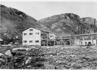

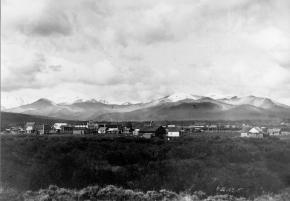
Monarch, now a picturesque lake for meandering around on a pleasant summer day, was once a bustling town, the home of the Monarch Consolidated Gold and Copper Mining and Smelting Company, and the rail head of the Rocky Mountain Railroad.  The life of this little company town and railroad was very short lived and now nearly forgotten. 

Boulder business men T.S. Waltemeyer, and Frank and Charles A. Wolcott heard about traces of gold, silver, and mostly copper at the junction of the Arapahoe Creek and the South Fork of the Colorado River.  In 1905 they established the Monarch Consolidated Gold and Copper Mining and Smelting Company and built their company on the assumption that a major belt of minerals extended east through the Continental Divide.  The Monarch Company consisted of several subsidiary companies including lumber companies, an "investment" company, an exploration company, and a development company.  The main objective of the company was to mine metal ores, but supplement it with timber and build a railway to benefit the whole corporation. 

The company had 1740 acres of placer and lode claims; the main mines were the Copper King, Copper Queen, Omaha, Ella C., and High Lonesome. The Monarch Company shipped heavy machinery by flatbed cars to Granby on the new Moffat Road.  They then put an ad in the paper asking for bids to haul heavy machinery 16 miles from Granby to Monarch.  The machinery included "5 boilers (eight and a quarter tons each), one engine (over eleven tons), one flywheel (6 tons), other machinery (from 1 to 5 tons), a carload of nails, and several hundred pounds of miscellaneous supplies."  The task of hauling the heavy equipment was made especially difficult by mud-holes and bridges not made for heavy loads.  Denver hauling companies refused to take on the job and one Swedish logging company from Wyoming abandoned the challenge after the first wagonload stuck in a mud-hole.

Finally Dick McQueary agreed to move the machinery.  To accomplish the job, McQueary purchased several hundred feet of hardwood planks in Denver, 3 inch thick, sixteen inches wide and twelve feet long.  Accompanying the heavy pieces up the mountain was a "4 horse team hauling hardwood plank, a 4 horse team pulling six inch pine poles, 10 feet long, and a four horse team pulling two ton large nails".   The crew built temporary bridges across mud-holes by laying pine poles 3 feet apart with hardwood planks laid across the poles.  2 light loads were driven across to test bridge followed by the heavy load pulled by 12 head horses.  Finally the planks and poles were pulled up to be used at the next mud-hole.  The heavy machinery was hauled in 2 weeks.

Construction on the Rocky Mountain Railway, a standard-gauge line from Granby to Monarch, began in 1907.  The 16 mile line was completed by Thanksgiving.  There were hopes of someday extending the line to Grand Lake for resort passengers and eventually a line to Walden in North Park.  The Denver and Northwest Railroad Company helped survey the line by lending J.J. Argo's services.  Dick McQueary was once again brought in to grade the road bed between the Monarch mill and Granby.  Most of the workers on the railroad were Japanese, Bulgarian, Hungarian, and Austrian day laborers from an employment agency in Denver.  The laborers were paid $2 a day, (plus a fifteen cent fee for their interpreter).

Once the railway was completed and in operation it issued passenger tickets.  However, the company never published a schedule.  Neither did the company hire a full train crew to run their single locomotive.  To meet regulations for switching service on Moffat tracks in Granby, the Rocky Mountain Railroad took on board a couple of interested bystanders.  At gates crossing ranch properties fireman Leo Algier would simply jump off the train to open the gate and close it after the train had crossed through before hopping back on the train.  Ranching families on the line were allowed to catch rides on the train when it passed through or to request package drop-offs. 

The Monarch Company created Monarch Lake by damming the valley, at the junction of Arapahoe Creek and South fork of the Colorado River, for use with the saw mill and the box factory. A 2800 foot long chute carried tree trunks down the hillside to the lake where they hit the water and could bounce up to 50 ft high.  Then a stern-wheel steamer pushed logs into a system of canals and flumes that led down to the saw mill and box factory. 

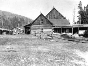
The town of Monarch included employee housing, business offices, a post office, and an assembly hall.  Dick McQueary helped haul sawlogs to mill and haul materials for building employee housing in Monarch.  Grand County's first hydro-electric generator was in Monarch.  The waterworks system was created by piping water from the falls at Mad Creek and had pressure up to 300 lbs per inch. 

Even thought the mining company never produced more than $150 a year, the owners continued to promote the business to stockholders and they were able to keep the business running by through their enthusiasm for the project.  During the summer, stockholders were invited to visit Monarch, tour the site, and hear lectures on the operation.  The tour often included a visit to a spruce tree named "Monarch" that was seven feet in diameter.  So, while business might not have been booming, enthusiasm and interest from stockholders was.  

The last piece of Monarch to be constructed was the box factory in 1907.  Unfortunately the factory only operated for 2 or 3 months before it suffered a fire and was totally destroyed.  Robert Black in Island in the Rockies stated that the questionable promotions of Monarch would have been forgiven if the box factory had developed into a solid operation. 

Soon after the fire, a disagreement between management and labor resulted in the entire work force being fired.  For several months the Rocky Mountain Railroad operated the train with one man who acted as engineer, fireman, brakeman and conductor. The company hired Dick McQueary as general manager until fall the fall of 1907 when stockholders discovered the true state of the company and declared bankruptcy.   Stockholders and the community were convinced that the whole company had been created as stock-selling scheme.

Although the Monarch Company and the Rocky Mountain Railroad were no longer in business, the railway continued to be used for a number of years.  For example, Ed McDonald, dude rancher, put a Cadillac touring car on flanged iron wheels to carry mail, supplies, and guests to his ranch.  The center of town was preserved and developed by the Dierks as a summer resort called Ka Rose, after Katherine Rose Dierks, after the owner's daughter.   In 1912 the rail line was used for transporting fisherman along the river by Ernest F. Behr, a former Colorado and Southern engineman.  Finally, in 1918 the rails were sold to a junk dealer in Denver to satisfy the World War I need for scrap metal. 

Currently, the town, mill site, and box factory lay under the waters of Lake Granby and are inaccessible, except in years of draught.  However, there are a couple of remaining pieces at Monarch Lake that are still visible.  On the south side of the lake, near the water's edge, is a boiler that was used to yard logs into a chute and shoots the logs into a holding pond.  Also, the flume still runs down the hillside into the lake.  The trail around Monarch Lake takes hikers directly under the flume.

Articles to Browse

Topic:

Agriculture

Article contributed by Scott Rethi

The first settlers in Granby realized the sunny days and cool nights were perfect for growing one crop in particular, lettuce.  Lettuce farming boomed in the 1920's and a new industry was born.

Granby had become an important railway center as tracks were laid over the Divide at Rollins Pass,giving the Moffat Railroad access to Salt Lake City. Granby produced some of the best-known lettuce
in America.  There are even tales that New York's Waldorf-Astoria Hotel bragged of their “Granby Lettuce” on the menu.  

Then a blight settled into the soil, probably brought in by the wooden crates used for shipping, and the lettuce business was ruined. Since then, ranching has replaced agriculture as Granby's major industry.

Sources:
www.byways.org, national scenic byways online, 2003
www.grandcountynews.com, Johnson Media, Inc., 2000-2002
www.djhome.net, 2002

Topic: True Crime

The Selak Hanging

Fred Selak was a descendant of early settlers in Grand County.  He built a cabin three miles south of Grand Lake where he lived alone.  He helped his brothers in various enterprises including mining, a general store and a sawmill.  Selak was known to be a prosperous citizen who lent money to others and there were rumors of hidden cash and gold in his cabin.  He was also known to be an avid coin collector. 

When Selak failed to pick up his mail for several weeks, the postmaster visited his cabin July 26, 1926. After not getting a response to his knocks, the postmaster summoned an employee of Selak's with a key.  When they opened the door, they discovered the cabin in shambles and Selak missing.  Sheriff Make Fletcher was notified and a nephew of Selak's called in the Denver Police Department. 

As the investigation progressed, a .22 caliber slug was extracted from the wall and blood was found on an easy chair, but further investigation ruled these clues inconsequential as they were dated to many years prior. Sheriff Fletcher conducted a massive manhunt on August 16th and the body of Fred Selak was found on the second day by a deputy's dog.  The body was hanging from a tree and evidence showed that, because of a sloppy knot, Selak did not die quickly of a broken neck but rather suffered a slow strangulation.  The murder had taken place a month earlier and the body had stretched until the feet were touching the ground. 

Arthur Osborn, 22, and his cousin Roy Noakes, 21, became prime suspects after showing off old coins and trying to spend them for minor purchases around Grand Lake.  After interrogation by the Denver Police, both confessed to robbing and killing Selak.  Later, Noakes claimed that the confessions were coerced by the police. 

The suspects were kept in the Denver jail until their trial on March 7, 1927 and Sheriff Fletcher had to take great precautions against a possible lynching.  The only motive for the murder seems to be based on a land dispute years earlier in which Osborn was arrested for a violating fence line.  Both suspects were found guilty and sentenced to death.  After many appeals, the convicted murderers were hung in Canon City on March 30, 1928.  

Topic: Agriculture

Worm Farms and Other Gardens

Have you ever heard of a worm farm? Harry French Sr., who lived for many years at Azure, on the Colorado River, loved to fish, anywhere and anytime.  He had brought the first angleworms into the valley from Iowa.  At his Azure homestead, he made a worm bed and got his worms established. Pretty soon, everybody came by to get some worms for their own needs.  

Worms can’t be found just anywhere in these high mountain valleys. However, at the Arkell place (Diamond Bar T) on Ranch Creek in the east end of the county, luckily someone had planted worms in a corner of the garden plot and this was the only place the Arkells could find worms.  At one point, Gertrude Arkell’s cousin Rose started a small business, digging worms from the garden and selling them to fishermen who happened by.  She even charged the rest of the family if they wanted worms!  

Gertrude described planting their own garden in 1916 after they moved to the ranch.  Papa spread several loads of well-decayed fertilizer from an old corral onto the garden and plowed it, creating a fine base for his vegetables.  Of necessity, pioneers coming into Grand County started immediately to see what would grow here.  They had to eat, and gardens were one of the first items on anyone’s agenda.  Coming over Dice Hill from the Blue and into the Sheephorn area about 1880, Joseph McPhee, a Scot, homesteaded the grass-covered McPhee Flats in Garden Gulch, site of the first garden in the area.  There were only two other homesteads on the Sheephorn at that time.  

Possibly Nancy Veatch Schissler, (Mrs. Henry Roric) planted the first garden on the Williams Fork in 1883.  She asked the men to plow her a bed, but they were positive nothing would grow.  So, undaunted, she planted lettuce, onions, and radishes on her dirt roof and potato peelings along the ditch bank, all of which grew!  Her little daughters fetched pails of water to hand to her up on the roof for irrigation.  

George Henricks, on the farthest reaches of the Troublesome, rarely had access to stores.  His wife, Aurella, bravely started radishes on her sod roof before the ground thawed, later transplanting them to a sheltered spot along with other vegetables.   What were the usual high altitude crops?  Lettuce, green onions, peas, root vegetables, and beans generally grew well.  Willis Call near Kremmling brought the first white potatoes to Grand County. 

Now, the Arkells on Ranch Creek had been told that at 8900 feet altitude, beans would freeze, and they did.  So did the potatoes, except those planted high up the hill in a spot where the soil was deep and black.  An aspen grove had grown there once, maybe for hundreds of years.   The family anticipated a good crop, but in early September or even in late August, a heavy frost completely melted the patch down.  That crop yielded bushels of small potatoes, few larger than golf balls.  Still, the Arkells stored them in their so-called ice-house, because until Papa got a cellar dug, there was nothing else.  They hoped the ice-house would keep the cold out, as it did heat, but the potatoes froze as hard as rocks.  Mama would bring in enough for a meal and immediately put them into a kettle of boiling water.  When done, they tasted like fresh potatoes! 

Before July, the family had early green onions, lettuce, and radishes, since these didn¹t mind the frost.  They froze every night but still lived, grew, and were good.  The white radishes grew long, slender, and crisp.  Head lettuce could be eaten early as leaf lettuce, or later as a fine firm head.  Peas didn’t mind the cold either but grew fast and tall. The package advertised them as “Telephone Pole Peas.”  They bloomed, set on peas ready to pick, and kept right on blooming and growing more peas, producing right up till early frost.  By late July, the Arkells had small rutabagas to eat, a crop new to them.  Turnips in late July were already large, and by fall they were gigantic but still sweet and good to eat raw. Turnips were pulled in the fall and stored in a great pile. Rabbits chewed off the outer skin and ate it but left the rest.  The remaining skinless turnips soon froze and made good cow feed.

Actually, a number of ranchers grew turnips for cattle food, particularly for show cattle.   Over on the Sheephorn, Helen Anghern Curry related that families shipped plenty of potatoes and peas out of Radium to Denver.  Farmers had to get up very early to pick the vegetables in order to get them on the train. That was almost fresh!  

Grain was grown more commonly than one might expect, especially on the west end.  For instance, a young English chap on the Blue River, Tom Pharo, experimented with growing vegetables and grain as early as 1877.  The Company Ranch on the Williams Fork planted many acres in grain.  And Dr. Hoagland, on the Blue, regularly put in oats and barley for two years, before planting seed for hay crops, in order to break up the soil and gradually level the rough ground.  Others raised many grains such as wheat, rye, oats, and barley, as well as hay.   High altitude lettuce became a main crop to be shipped out of Grand County about 1920.  Before this decade, lettuce sent by train was grown, especially on the upper Sheephorn and on the Blacktail. 

Later, centered around Granby, farms spread to the Williams Fork and the Troublesome, as well as Ranch Creek.  Japanese laborers harvested much of the crop.  In 1919, there had not been a single truck farm in the county; in 1929, there were 34.   On the Troublesome, Roy Polhamus was famous for his lettuce.  His daughter, Catherine, lined the crates with heavy paper in the packing shed. After being cut in the fields, trimmed of bad outer leaves and packed, the crop was shipped to Denver by truck. It depended on how big the lettuce was as to how many dozen would fit into the crate.  Roy also grew enough potatoes that he could spare many for Granby stores in the winter.  

Encouraged by Nathan Hurd, a Mr. Henderson, on a little ranch straddling the shoulder between Hamilton Creek and Ranch Creek, tried growing lettuce long before the lettuce craze the west end of the county. Nobody had thought of growing it before and people were quite sure he was crazy.  His lettuce was as sweet as any ever tasted, but when the big craze hit, for some reason he gave it up.  Before he quit, he had some 2000 crates of Los Angeles Head Lettuce to sell and planned for 40 acres the following year.  Everyone laughed at him two years before when he started, but the laugh was on them now.  His 2 1/2 acres of jackpine paid him over $750/acre.   The lettuce was grown on new ground and no water; ­dry land farmed.  He called his place “The Happy Lettuce Farm”. 

In the same area, a group of Basques did all the work.  They irrigated at night, little lights at hand to show them the way.  This local lettuce was stored in Tabernash in a shed, before being put on the train.  This shed was later hauled to Granby and became the Grand Old Inn.   Other crops were raised, too. 

At Radium, sweet corn and strawberries were grown for sale.  Harry French’s wife, Mary, had a very green thumb, and at the 1914 County Fair, special mention was given to “Mrs. French of the Sheephorn area, then age 77, for her splendid display of Brown Australian onions, raised from seed.”  In addition, “she had a very handsome display of crabapples and tomatoes.”  Mike Leroux, also in the Sheephorn area, said that his family almost always won a prize at the county fair in Kremmling, because they had one of the few spots in the county where one could grow apples!   Women and children gathered wild berries for jams and pies.  Wild strawberries, raspberries, and gooseberries went into these treats.  The residents on the Troublesome picked chokecherries, and service berries, currants, in addition.  

Marie Craven George remembers growing rhubarb at their cabin.  Some of it still grows there.  Many years later, after Marie married, she and her husband dug up some of that rhubarb and took it to their own garden in Kremmling.  Marie remembers that, as a little girl, she stuck a gooseberry up her nose once and they had to hang her upside-down and spank her, until she sneezed the berry out.  She decided gooseberries were for pies and jams, not noses!  

Getting off the train, the Arkells often walked from Arrow, to check on the raspberry crop, for great quantities of bushes grew along the tracks.  The wild strawberries, though very small, were so full of unexcelled taste that one cup would be enough to flavor a shortcake for all of them, with whipped cream on top.  Using a kind of rake, they also gathered gooseberries, wild currants, and wild blueberries, which grew everywhere.  Bob Peterson maintains the best berry patch for blackberries or red and black currants was on Cabin Creek a mile of so above Devils Thumb Park.

Topic: Regions

Fraser Valley

The principal population centers in the Fraser River Valley are Winter Park, Fraser and Tabernash.  When the early stage coaches came over Berthoud pass into the Fraser Valley, the most popular stop was at the Cozens Ranch, which now houses a historical museum in Winter Park. The valley is now bisected by U.S. Highway 40, which was designated the "Victory Highway" in 1931.  The new route of the highway leads through the main streets in both Fraser and Tabernash and the backdoors of some business became front doors because of the new highway alignment.   

Tabernash was the name given to a railroad siding, named for the Ute leader who was killed during a confrontation with local ranchers.  The town became a key station on the railroad line, and included a roundhouse, and a supply of helper engines for the steep climb over Rollins Pass.  When the Moffatt Tunnel was opened in 1928, the railroad no longer needed service there and the town lost its' main economic support.

George Easton founded the town site of Fraser in 1905.  The rest of the country became familiar with Fraser when the winter temperatures were often the lowest recorded in the U.S. and Fraser was know by the nickname "Icebox of the Nation".   Lumbering was one of the prime industries in the region until World War II.  During the war, the military built a Prisoner of War camp at Fraser to help lumber for the mills in the area.

The current area of Winter Park has had many names over the years.  First it was called simply "Old Town" or "Vasquez", named after the fur trader Louis Vasquez.  "Woodspur" or "Woodstock" referred to Billy Wood's lumber mill in the area, which furnished ties for the railroad while it was being built over Rollins Pass. During the construction of the Moffatt Tunnel, the name "West Portal" came into usage.  Rail workers also called the community "Little Chicago" as it was as it was a favorite gambling, saloon, and brothel site.  As tourists began to arrive it was known as "Idlewild" and also "Hideaway Park".  Finally, the name "Winter Park" was settled upon to correspond with the adjacent ski area of the same name.

The area population declined from 1232 people in the 1920's to only 373 people by 1930.  The Great Depression ended the construction boom and the price of beef became too low for ranches to turn a profit.  However, since that time, the area has thrived, mostly based on a tourism economy.  The valley's main source of income is now recreation and second home construction. 

Topic: Railroads

Railroads

Construction on the railroad line from Denver to Grand County began in July 1902.

The project, called the Moffat road (officially the Denver, Northwestern & Pacific), was the seemingly impossible dream of David H. Moffat, who spent much of his personal fortune building the tracks over the Continental Divide.

The rails pushed higher and higher up the mountains until they reached a station named Corona, meaning the crown of the continent.

Corona was the highest point in the world with a standard gauge railroad and the journey from Denver in the winter was perilous at best.

Huge snowplows were required on either side of the Divide to keep the tracks clear.

Eventually, in the late 1920s, a tunnel was dug through the range, eliminating 22.84 miles of track and the breathtaking journey over Rollins Pass.

The railroad reached Granby and Hot Sulphur Springs in 1905 and Kremmling in 1906, and played a significant role in building the population of Grand County.

In 1900 the total resident population of Grand County was only 741, but grew to 1,862 in 1910.

Topic: Places

Place Names

Article contributed by Kathy Zeigler

The County of Grand was established in 1874, taking its name from the Grand River which has its headwaters in the county, and from Grand Lake, the largest natural body of water in the state of Colorado.  The county seat is Hot Sulphur Springs.  The area of the county is 1854 sq. mi., making it larger than the state of Rhode Island.

Fraser was established in 1871 as the town of Eastom.  Its name changed to Fraser, after the river that flows through the town, though it was originally spelled Frazier, for Reuben Frazier. The Post Office adopted the simpler spelling at the establishment of the Post Office.  The town bore the distinction of being the "icebox of the nation" for many years, losing that title in a legal battle with a town in Minnesota.

Granby was established in 1904, taking its name from Granby Hillyer, a Denver attorney who may have been associated with the founding of the town.

Grand Lake was established in 1881 as a mining settlement by the Grand Lake Town and Improvement Company, taking its name from Grand Lake.

Hideaway Park was established approximately 1905, and named for its hidden location with the trees screening it from the road. It may have been earlier known as Woodstock, Vasquez and Little Chicago. Max Kortz, owner of a dance hall in the village is said to have provided the moniker. 

Hot Sulphur Springs was established in 1860 and named for the hot springs.  It may have been refered to as Sulphur Springs in its earliest days, and as Sulphur by the workers and management of the Denver and Salt Lake Railroad when it came through in 1904.

Kremmling was established in 1881 as a general merchandise store, owned by Kare Kremmling on the ranch of Dr. Harris, located on the north bank of the Muddy River. In 1888 John and Aaron Kinsey had part of their ranch platted, calling the site Kinsey City. Kremmling moved his store across the river to the new site; eventually the town came to be known as Kremmling.  (Note the two different first names-Reuben Kremmling and Kare Kremmling.  I'll keep working on that discrepancy.)

Radium's name was suggested by Harry S. Porter, prospector and miner, in reference to the radium content in one of his mines.

Winter Park was first known as West Portal, a settlement that grew up during the construction of the Moffat Tunnel in the 1920s.  Postal authorities agreed to the name change to Winter Park, after a request was made by Denver mayor Benjamin F. Stapleton and many sport enthusiasts to publicize the establishment of a top winter sports area.

Berthoud Pass, el. 11314, was named for Capt. Edward L. Berthoud. Berthoud discovered the pass in 1861. He was also chief engineer on the Colorado Central Railroad.

Gore Pass, el. 9524, was named for Sir Charles Gore, who mounted a monumental "hunt" to the American West during the 1850s. Gore spent considerable time in the area, and gave his name to the Pass, a mountain range, and a canyon.

Milner Pass, el. 10759, was named for T.J. Milner, and accomplished civil engineer for railroads and street car lines.

Muddy Pass, el. 8772, bears the name of Big Muddy Creek, a tributary of the Colorado River, with reference to the muddy appearance of the waters during the spring runoff and storms.

Rabbit Ears Pass, el. 9426, refers to Rabbit Ears Peak, whose outcroppings somewhat resemble a rabbit's ears.

Willow Creek Pass, el 10850, is named for the stream, and almost certainly for the willow bushes that line the banks of the stream. The pass was a well known Indian trail, and became a road in the early 1900s.

Source: Eichler, George R. Colorado Place Names. Boulder: Johnson Publishing, 1977.

Topic: Towns

Tabernash

The town of Tabernash was established in 1905 on the location of the old Junction Ranch. The name came from the Ute Indian, Tabernash, who was killed here in 1878 during a confrontation with a posse sent to stop the Indians from tearing down fences and racing their horses on the white mans newly "private" property.

In 1913 the locomotive terminal was relocated from Fraser to Tabernash by the Denver and Salt Lake railroad. When the Moffat Tunnel was completed, the need for the terminal diminished, but the community persisted with a ranching economy.


Topic:

Community Life

What was it like to live in Grand County in the 1800's or the early 1900's?  Click on the drop down menus and find out about community life in the “olden days.“

Topic: Mining
Mount Baker

Gaskill and the Wolverine and Ruby Mines

Mount Baker

The Wolverine Mine was discovered in 1875 by James Bourn and Alexander Campbell. Bourn was the brother-in-law of James Crawford, the founder of Steamboat Springs. James Bourn was the twin brother of Crawford's wife, Maggie.  A Grand County recording error forever changed the name of Bourn in the area to "Bowen".  The mine was located in the Rabbit Ears Range on Bowen Mountain, up Bowen Gulch, approximately 10 miles northwest of Grand Lake.  This discovery sparked additional exploration in the area that lead to a number of new mines. Within a week of the original discovery,  interested parties formed the Campbell Mining District which included Bowen Mountain, Bowen and Baker gulches.  Some of the Middle Park residents who participated in the mining exploration  were John Baker, Charles Royer, Charles Hook, John Stokes and the Redman brothers, William and Mann. The Redman's  eventually  discovered the Sedalia mine. Bourn and Campbell  in less than a year lost the Wolverine mine by not fulfilling a grubstake agreement with the Georgetown grocers, Spruance and Hutchinson.

John Stokes leased the Wolverine Mine from the grocers until Edward Phillip Weber, an agent representing a group of Illinois investors, purchased the Wolverine Mine in the Summer of 1879.  Weber continued purchasing other Campbell Mining District claims which created a great deal of local excitement.  Weber hired Stokes  to assist him and also hired Lewis Dewitt Clinton Gaskill to act as the first foreman for the Wolverine mine.  Gaskill had mine operation experience, having successfully operated the Saco Mine, on Leavenworth Mountain, above Georgetown for several years.  A mining camp was built  below the Wolverine Mine that contained a large bunk house building and a more substantial mine office building.

Gaskill, a Civil War veteran of the 28th  Regiment of the New York Volunteer Infantry,  had come to Colorado in 1868 as a representative of a group of Auburn, New York bankers to invest in mining properties.  He eventually successfully operated the Saco mine in 1873 and 1874.  He invested in the Georgetown, Empire and Middle Park Wagon Road in 1874, which was a toll road that finally made the Berthoud Pass road passable for wagon traffic.  Gaskill also acted as the foreman during the construction of the road. The principal investor in the road was William Cushman of the First National Bank of Georgetown. The bank had a financial collapse in 1877.  At that time, Gaskill was the secretary of the road company and lived with his family in the company house just below the summit of Berthoud Pass on the west side.  William Hamill, a wealthy Georgetown businessman, bought the wagon road in a foreclosure auction in 1881 for $7,000.  Gaskill continued to live with his family in the Berthoud Pass summit house until 1885, when he moved his family into the Fraser Valley and homesteaded 160 acres along Elk Creek.

The settlement of Gaskill began when  in August of 1880,  Al J. Warner built a log cabin store in a meadow below Bowen Gulch on the trail/road that lead to both Bowen Gulch and Baker Gulch.  The settlement was also strategically well placed midway on the trail/road between Grand Lake and Lulu City and the Lead Mountain Mining District.  Another store was built in September by  John K. Mowery.  By that October, Mowery was appointed as the first postmaster of Gaskill.  The following spring E. Snell, opened a large general merchandise store that prompted the original store keeper, Al Warner, to relocate to Grand Lake as Al's Place. The town was named to honor L.D.C. Gaskill, the greatly respected foreman of the Wolverine Mine, the road builder/operator and the Civil War veteran.  By 1882, the town covered 60 acres.  E.P. Weber of the Grand Lake Mining and Smelting Company got involved in the town real estate development by laying out a city grid and offering lots for sale.  Weber's plat renamed the town Auburn after L. D. C. Gaskill's home town of Auburn, New York, but the Gaskill name stuck.  By the close of 1882, there were over 100 residents living in Gaskill.  The most substantial building was the Rogerson House, a well appointed two  story, squared log hostelry, Horatio Bailey Rogerson, proprietor.  Rogerson, would be elected County Commissioner in November of 1882, but would not serve because of a sudden discovery of ineligibility.  Instead, lame duck Colorado Governor Pitkin, appointed E. P. Weber to the post.  Weber was killed in the infamous July 4, 1883 shoot-out at Grand Lake.   

The Bowen Gulch trail lead to many of the  most productive and worked mines in the Campbell Mining District which included the Wolverine, now owned by the Grand Lake Mining and Smelting Company, E. P. Weber superintendent and the Ruby and Cross mines owned by Kentucky and Colorado Mining and Smelting  Company, John Barbee superintendent. Barbee, who lived in Grand Lake,  would go on to serve as superintendent of schools, Justice of the Peace and briefly the editor of the Grand Lake Prospector.  Barbee's partner in many endeavors was Antelope Jack Warren. Warren was as rough as Barbee was refined.  He acted as a foreman and, by one account, a bodyguard for Barbee.  The Bowen Gulch trail continued up the mountain to Bowen Pass and then descended into North Park and the Jack and Park mining districts which were organized by the end of 1880, to the settlement of Teller City.  Passable roads that could handle wagon traffic were needed and often planned but rarely built.  The high cost of building and maintaining  wagon capable roads in Middle Park was a difficult proposition for local governments and private entrepreneurs.  

The Grand County Commissioners in July of 1877 had declared the trail from Grand Lake to the mining gulches of the Rabbit Ears  Range to be a county road.  However there was little county money to pay for improvements to make the trail a road.  Private investors were reluctant to invest in wagon roads when there was the persistent  rumor that railroads were coming spawned by the numerous railroad surveys that were performed in the area.   Albert Selak, a Georgetown brewer, in August of 1878, organized a toll road that would branch off of the Georgetown, Empire, and Middle Park Wagon Road at the Ostrander Ranch on Red Dirt Hill, and proceed to Grand Lake and continue on to the Rabbit Ears Range mines and continue on into North Park and on to the Wyoming territory line.  John Barbee invested in the Middle Park Toll Bridge Company, a toll bridge company that intended  to build a bridge across the Grand River  above the confluence of Willow Creek and the Grand River.  However, this project languished, and was taken over by the county with an expenditure of $150.  

If ore wagons would need to haul ore to the nearest reduction mill which was over 60 miles in Georgetown, the toll road might have been a financial success. However, the lower grade ore from these Rabbit Ears Range mines would not yield a sufficient profit to cover the transportation and processing costs in a market where the market value of silver annually declined.  So the ore piles grew.  What was needed was a nearby reduction mill or cheaper transportation, like a railroad or a higher price for silver.  Weber had  repeatedly promised that a reduction mill was coming, but nothing was ever built.  By April of 1883 with tons of ore piled up and waiting for transport to be processed,  Weber temporarily closed the Wolverine Mine and laid off his miners.  He admitted  in June of 1883 that the ore from the Wolverine was “rather refractory” and that it would not justify shipment without local reduction.  Some hoped the closing was a strategic move by Weber to trigger a sell off of area mining properties  so that he could acquire additional mines before he built the reduction mill, but it was not to be. Weber would soon be shot dead by his political rival, John Gillis Mills.

The favorable newspaper stories of Rabbit Ears Range mining would continue, but for the informed, it had become  clear that without a major investment in improved transportation including a railroad or a major investment in a reduction mill in the area, the mining concerns were doomed to fail.  Mining claims had to be worked in order to be kept.   A minimum of $100 of labor or $500 in improvements had to be expended each year to maintain the claim or else the claim would be deemed abandoned.  Many claim holders leased their claims to miners to work for a percentage of the return.  Without the ability to sell and process the ore for a profit, there was no return.  The speculative mining investment money began to dry up and the miners and their supporting merchants began to leave.  By the end of 1886, the Middle Park mining boom had  ended. To further add to the decline,  a border dispute that arose between Larimer County and Grand County over the taxation and mineral wealth of North Park was finally decided in 1886 by the Colorado Supreme Court in favor of Larimer County.  North Park was part of Larimer County, not part of Grand County.  A lawsuit would follow so that Larimer County could recover the wrongly collected taxes of $20,000 from Grand County.  Grand County's total tax income at the time was less than $3,500 a year.

Topic: Water

Moving Water from Point A to Point B

Most serious ranchers had more than one ditch and most built one or more reservoirs. Hilry Harris, Munroe C. Wythe, Samuel H. Burghard, and John A. Coulter entered the first water claim in the county on September 20, 1874. This came out of Sheep Creek above the head of Gore Canyon.

There usually was some natural irrigation; but the challenge of getting the water from the creek required laborious construction of diversion dams, headgates, and ditches, the earliest ditches being dug by hand and often taking up to four years to complete. Later, ditches were dug using teams and scrapers. The grade was figured out initially by simple gravity flow, letting a trickle of water move down the ditch. Soon ranchers refined the process, using a 16’ long board placed with a 1/8" slope, determined by a carpenter’s level. A.F. and Roy Polhamus surveyed a great many of the water ditches, especially those impressive ones in West Grand County, some of which even had tunnels involved. Most small ditches supplied just one ranch, but if a ditch had to cross another ranch, that rancher usually got a share. And some of these ditches were long!

For instance, Dr. Henry Hoagland, on the Blue River, anticipated getting water close at hand from Spruce Creek. Instead, he discovered an old timer had previous rights that forced him to go back into the mountains and build a 13-mile long ditch. Hoagland had figured on spending about $7000; in the end, the actual cost was $26,000! His crew dug the ditch around side hills and across valleys using flumes and siphons. Then his real troubles began. Terrible leaks and washouts occurred everywhere. Finally he hauled in adobe and put this in the bottom of the ditch, rented sheep, and drove them day after day up and down the ditch to pack it. After a couple of years of using this tamping process, the ditch held. Other ditches were even longer. The Church Ditch at Willow Creek and the Wheatley Ditch on the back Troublesome were both 16 miles long.

The Company Ditch (aka the Williams Fork Ditch), eight feet wide on the bottom, was another long one. Built between 1903 and 1907, it cost $44,000 and had a decree for 150 cubic feet / second. The ditch went uphill and down, requiring many flumes and bridges. One flume was actually 1200 feet long! Subsequent breakdowns, leaks, and slides were so frequent and repairs so extremely costly that old-timers have said the reason the Company Ranch went broke about 1920 was the expense of The Ditch. The Lyman Ditch (or the Curtis), started about 1891, was just as complicated as the Company Ditch. Crossing high above the Williams Fork River, the ditch eventually needed cement piers to carry the pipe (1928). This ditch had so many slides, leaks, and washouts, that it had to be inspected once or twice daily! Siphons were required over draws. Flumes, sometimes ¼ mile long, might be 25-30 feet high, and one flume was actually 177 feet high; but these heights were necessary to maintain the elevation.

Flumes, being of wood, rotted and were guaranteed to leak. Sometimes wind blew a portion of the flume down. Finally the county put in big pipes to help the ditches across the Williams Fork. It might be noted that, when water leaked out of ditches, a side benefit was that ranchers along the way could use the "lost" water. Along with the ditches came reservoirs.

Fred DeBerard had four reservoirs on the Muddy: the Albert, the Binco, Milk Creek, and a low one that flooded the Jones place near Kremmling. All were dirt, of course. The Hermosa Ranch on the Little Muddy had water rights through the Sylvan Ditch and Reservoir Company and they built the Sylvan Reservoir dam and the Hermosa Ditch starting in 1911 and completing it by the spring of 1916. The Stein Ditch, started in 1897, was another large ditch, this one later purchased by the Taussig family. These ditches were all built originally to provide water to meadows and fields for ranching purposes. For years, people hauled in water for baths and household use, but that gradually changed. Leon Almirall, near the Horseshoe Ranger Station on the Williams Fork, decided that he wanted water for his home, so he built a 1700’ pipeline to his house, added an inside bathroom, and was shocked when the line froze the first winter – it was only three feet deep. He called in workers who dug down and insulated the line with manure and straw. It froze again. Finally, Almirall gave up and buried the line six feet deep. Now he had his water!

On Ranch Creek in the east end of the county, E.D. Shew cut a ditch upstream from his house, placing it along the edge of the creek, but directing the water back into the main channel near his house. At that point, he put a little water wheel that pushed the water up the hill to his cabins -- and furnished electricity besides. Eventually he replaced the water wheel with a gas engine. There was a similar water wheel, used for the same purpose, up in Hideaway Park.

Water was used to transport lumber as well. A flume ran down the mountain into Monarch Lake, in the days when the Monarch Company was timbering there. There was a flume along St. Louis Creek, carrying lumber from the camps upstream. Perhaps the most ambitious flume ran from Western Box Sawmill. This area is now under Meadow Creek Reservoir. In 1906, the Deisher Lumber Company paid Nathan Hurd for a right of way through his land and built a flume with a 2% grade down Hurd Creek. Logs were placed in the flume and a horse harnessed to the last log. The horse then pushed the logs down the flume with the help of the water. Three years later, the mill was moved to "Sawmill Meadow" on Meadow Creek.

In 1911 construction on the seven-mile-long Vaver Flume began, with 117 cubic inches of water allotment. This flume ran down Meadow Creek and over to Tabernash, carrying partially processed logs for further manufacture. A flume rider checked along the way, making sure there were no jams, and phone line allowed the rider to report troubles. Hikers can see remnants of both the St. Louis Creek flume and that one coming down Meadow Creek today.

Error message

  • Notice: Undefined index: quantity in omega_views_mini_pager() (line 234 of /var/www/html/docroot/sites/all/themes/omega/omega/inc/theme.inc).
  • Notice: Undefined index: quantity in omega_views_mini_pager() (line 234 of /var/www/html/docroot/sites/all/themes/omega/omega/inc/theme.inc).

Monarch