Railroads

Construction on the railroad line from Denver to Grand County began in July 1902.

Railroads Articles

Moffat Road
Moffat Road


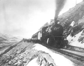
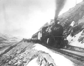
"I shall never forget it as long as I live. Nor do I ever expect to experience anything comparable to it again. Civilization had found its way across the mountains into Middle Park," reflected Mrs. Josephine Button in 1955 on her 91st birthday, as she recalled seeing smoke from the first Denver Northwestern and Pacific work-train on Rollins Pass, high above the Fraser Valley and Middle Park. Once those rails made it over the Continental Divide all the way to Hot Sulphur Springs, "changes came thick and fast." Many men, many dollars, many routes and many dreams tried to bring a railroad over the Continental Divide into Northwest Colorado, and the "Hill Route" over Rollins Pass that finally accomplished it a century ago has retained its allure ever since.

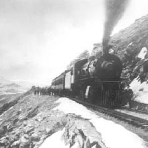
The Moffat Railroad built a cafeteria, telegraph station, living quarters for Moffat's "Hill Men" (as the railroad crews up there were known) and a fine hotel - all collectively called Corona Station. Soot-filled snow sheds protected over a mile of this windblown section of track. And where today silence is the most powerful sense, colorful locomotives pulled passenger and freight cars, filling the rare atmosphere with black smoke and mechanical clatter.

Decades of men's dreams lay behind the once massive snow shed that cut the bitter winds from the north and west, behind that fine hotel that offered some of the most spectacular scenery in America, behind the hopeful Town of Arrow nestled below tree-line ten or twelve miles west of Rollins Pass, and behind that first work-train that Josephine Button watched from her hay ranch along the Cottonwood Pass Wagon Road to Hot Sulphur Springs. Competent, often powerful, men in the 1860's through the 1890's filed surveys, graded road beds, and even began drilling before being stopped by severe storms that foiled the best laid plans or their inability to fund the ambitious projects.

Dreams to penetrate the high mountains along the Divide in central Colorado began when the Front Range was flooded with miners during the Gold Rush of 1859. Even before Colorado became a territory in 1861, Golden City, just west of Denver along Clear Creek, recognized its potential as a gateway to the rich mineral resources of mountain towns like Central City, Black Hawk, and Georgetown. Golden City's ambitions went beyond becoming a mountain transportation hub, believing that with the right incentives, enthusiasms, and leadership, its location supported a future as a national commerce center. 

Golden City certainly had men of vision, ambition, and wealth among its ranks. William Loveland and George Vest, both young and feverishly ambitious to see Golden City reach its potential, vigorously pursued their dreams for a powerful commercial center in Golden City. From Missouri River towns like Leavenworth in Eastern Kansas, leading town founders also recognized the benefits of linking their water and rail routes to the east with the resources of the west. Finally, as if destiny had demanded it, Edward L. Berthoud, a young civil engineer and surveyor with energy and ability, arrived in Golden City from Leavenworth in April of 1860 to unite the similar passions of leading citizens from both locations.

From 1861 until 1866, Berthoud, Loveland and Vest focused on bringing a direct transcontinental railroad route through Golden City. First, Edward Berthoud, along with Jim Bridger and a capable young cartographer named Redwood Fisher, blazed a trail across Berthoud Pass through Middle Park all the way to Salt Lake City. Returning to Golden City on May 28, 1861, Berthoud reported "a good wagon road could be ?quickly' built" from Denver to Salt Lake City over Berthoud Pass for about $100,000.00. According to the local hyperbole, a railroad would surely follow.

In spite of considerable enthusiasm, disappointment plagued early efforts to put a rail line over the mountains in Colorado Territory. In 1862, Territorial Governor John Evans sent the Surveyor General for Colorado and Territories along Berthoud's route and others to confirm or deny the potential of a railroad line. About the same time, the Union Pacific Railroad Company sent an independent reconnaissance to examine potential routes over the divide that included Berthoud and Boulder Passes (Boulder Pass became Rollins Pass in the early 1870's, when John Quincy Adams Rollins built a toll road over it, and then Corona Pass when the Railroad crossed it). Surveyor General Case and the UP agreed that neither route offered much hope for a standard gauge railroad. The dream of a transcontinental line over the Continental Divide through central Colorado seemed to die with the UP surveyor's words, "I learned enough to satisfy myself that no railroad would - at least in our day - cross the mountains south of the Cache la Poudre..." 

Multiple failed attempts to bring a rail line over the Divide through Middle Park during the following decades strengthened the UP's "death sentence." Against the odds, Berthoud and Loveland continued to solicit support for a railroad west over or through the Continental Divide, using improved surveys and maps to support their requests. In the 1880's, survey crews from a variety of railway incorporations were scattered over the high country on or near Rollins Pass. Over Berthoud, Rollins and other passes, they marked potential railroad lines with their wooden stakes. It was during this stretch of strenuous surveying activity that David Moffat, a highly successful Denver capitalist, got involved with an unsuccessful effort to bring through the mountains instead of over the top. 

 In the early 1880's, Mr. Moffat invested in the Denver, Utah and Pacific Railroad, which intended to tunnel through the mountains near Rollins Pass. Like the other efforts, though, the Denver, Utah and Pacific vanished in a few short years. Unlike many other lines that accomplished little more than surveys and maps, the DU&PRR completed significant grading and began tunneling before reaching the "end of its resources."

Money, power and success supported Moffat's dream to put Denver on a direct transcontinental railroad line. Doctor Robert C. Black, III, wrote that David Moffat's failed efforts in the early 1880's converted him to the idea that Denver needed to be on a direct transcontinental rail line. Moffat considered the route over Rollins Pass valuable enough to have surveying and grading crews working on it throughout the winter in 1902. The Denver Rocky Mountain News claimed that Moffat's route through Northwestern Colorado included "the largest strip of fertile land as yet undeveloped in the United States..." With his Denver, Northwestern and Pacific Railroad, David Moffat planned to make good his intentions to put Denver on direct transcontinental railroad line.

Moffat's original plan called for the "Hill Route" over Corona Pass ? the name changed from Rollins Pass in honor of Corona Station at the top ? to last for only a few short years. While the "temporary" route over the top generated resources by extracting the resources of Northwestern Colorado, a tunnel was to be bored through the Continental Divide. Even the wealth and power of Moffat, though, failed to adequately finance the tunnel before he died in 1911. The temporary line, therefore, lasted for nearly of a quarter century, from 1904 until 1928.

Its obstacles proved as enormous as the mountains it crossed. Work crews had to cease operations because of snow for most of April in 1920. The road was closed from late January until May in 1921. In December of 1924, engine number 210 busted "a main reservoir pipe," causing the train to fly down the hill out of control until it jumped the tracks and crashed into the valley below. Clearly, the Denver and Salt Lake Railroad, which took over Moffat's DNW&P after his death, needed a tunnel to replace the expensive effort over the "Devil's Backbone."

 As Denver and Salt Lake Locomotive Number 120 came through the tunnel in early 1928, it represented the culmination of a massive undertaking through wet, unstable rocks which required considerable engineering ingenuity and caused six deaths in a 1926 cave-in. It also took an enormous amount of coordination and effort to secure the necessary funding. Through local bond issues, private investors and other means, the project was completed. And through a connection at Dotsero, a railroad station less than 30 minutes west of Vail on I-70, freight and passengers could make a direct Pacific connection from Denver. Posthumously, David Moffat's dream became a reality.

For significant periods of time since the trains stopped operations over Rollins Pass in the late 1920's with the opening of the Moffat Tunnel, on-road vehicles crept along its relatively easy grades and wide curves from Rollinsville on the east slope to Winter Park on the west side of the Divide. Like now, the road ran through an area attractive to backcountry campers and sport enthusiasts. On September 1, 1956, local officials and private citizens met on Rollins Pass to celebrate a "joint state-federal-county project to convert the old D. & S. L. railroad right of way over Corona Pass into an access road for sportsmen." According to the Denver Post, the game and fish department's construction division reconstructed the road during the summer of 1955 for about $20,000. The following year, the road became a scenic route over the Continental Divide for family cars and jeep caravans alike. And after it was built, or at least reconstructed, they did come. Intrepid tourists into Middle Park.

Railroads
Railroads

Construction on the railroad line from Denver to Grand County began in July 1902.

The project, called the Moffat road (officially the Denver, Northwestern & Pacific), was the seemingly impossible dream of David H. Moffat, who spent much of his personal fortune building the tracks over the Continental Divide.

The rails pushed higher and higher up the mountains until they reached a station named Corona, meaning the crown of the continent.

Corona was the highest point in the world with a standard gauge railroad and the journey from Denver in the winter was perilous at best.

Huge snowplows were required on either side of the Divide to keep the tracks clear.

Eventually, in the late 1920s, a tunnel was dug through the range, eliminating 22.84 miles of track and the breathtaking journey over Rollins Pass.

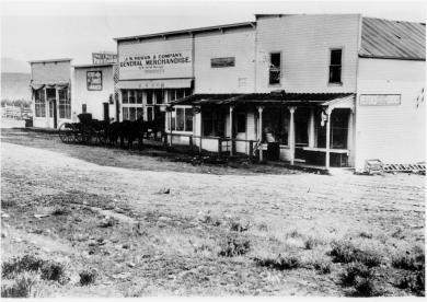
The railroad reached Granby and Hot Sulphur Springs in 1905 and Kremmling in 1906, and played a significant role in building the population of Grand County.

In 1900 the total resident population of Grand County was only 741, but grew to 1,862 in 1910.

The flood that built the Moffat Tunnel

Article contributed by Tim Nicklas


For many years Denver longed for its own direct line through the continental divide, linking the city to the west coast.  In the 1860s, Denver was slighted by the Union Pacific(UP), when the company chose Cheyenne as the major hub for the prized Transcontinental Railroad, before it snaked through the Rockies.  Fortunately, the city fathers of Denver did not give up on making their city the center of the Rocky Mountain Empire, as they risked financial disaster by bankrolling a spur line to the main route in Cheyenne.  Denver may not have had their direct route to the west and the fortunes that lay on the other side of the divide, but the city was not dead. 


For Grand County, the U.P.'s decision not to penetrate the formidable barrier of Colorado's mountains had a much greater impact.  As it stood Grand County had no for seeable future of gaining a rail line.  This meant that the only means of transportation into or out of the county was by pack animal or foot.  Furthermore, without a line to Denver, there was virtually no practical way for industry to develop in Grand County.


In 1904, Denver and Grand County's long awaited dream of a direct line through the mountains and on to Salt Lake City began to materialize.  The Moffat Railroad had risen over Corona Pass and descended into the Fraser Valley.  At the time Corona Pass was the highest rail pass in the world.  Along with this fact came the troubles of maintaining such a wonder.  The route was challenging to keep open in the summer with the violent storms that are prone at such a location.  In the winter the line would close all together.  Adding to the trouble of the unpredictable route was the fact that Colorado's economy of the 1870s was not the same in the early 20th century.


In the 1870s, much of Colorado's mineral wealth was centered directly west of Denver in Central City and Georgetown.  By 1880 many of those mines began to play out.  Furthermore, production shifted to the silver mines of Leadville and the Arkansas Valley.  As a result, rail traffic favored Pueblo over Denver.  Pueblo was situated on the plains as the Arkansas River exits from the mountains, eliminating the need for boring tunnels or climbing over arduous mountain passes.  In addition, Pueblo was close to the coalfields that were essential to power the locomotives.  Also, the city was the site of the largest steel mill west of the Mississippi, which supplied rails for the sprawling network.  Finally, Pueblo's smelters boomed when many others withered after the "Silver Panic" of 1893.  At the same time that depression gripped Colorado and silver was devalued, gold was discovered in Cripple Creek.  Within a few short years the new gold camp would become the world's largest producer.  As a result, nearby Pueblo would reap the benefits by converting from silver to gold, to become the smelting capitol of the nation.


By the early 20th century, Pueblo's status as an industrial powerhouse and rail center threatened Denver's status as Colorado's "first city."  This was even further evidenced by the "powers-that-be" in the northern part of the state being unable to convince the rest of Colorado to finance a tunnel under the continental divide west of Denver.  Time and again legislation that would fund the missing link between Denver and the western slope was defeated in the statehouse by those in southern Colorado who were content with their established web-link.  Barring a miracle, it looked as if Denver and Grand County would have to settle for the unreliable Moffat line over Corona Pass.  In 1921 that miracle would rush in, due to un-for-seen misfortune upon Colorado's "second city" in the south of the state. 


The spring of 1921 started as many do in Colorado, with a drought.  By June 1st the many farmers downstream in the Arkansas Valley feared disaster as crops withered with thirst.  On the 2nd day of June, the farmers got the relief of rain they eagerly wanted.  Unfortunately, the downpour continued until the formerly parched earth became like a sponge and the Arkansas River swelled.  The streets of Pueblo were ankle deep with water by nighttime.  Suddenly, with little warning, a torrent of water rushed from the upper Arkansas Valley toward the helpless "Steel City."  Pueblo's streets filled with water up to rooftops.  The unified rail-yard was ripped instantly.   Unfortunate train passengers were tossed unaware into the maddening grip of the Arkansas, unable to escape the iron coffins in which they were riding.  Families were stranded on roofs as row boats desperately searched for stranded victims.  As pungent water filled the business area with filth and debris, fires broke out.  Unable to do anything, citizens watched helplessly as fire and water consumed their city.  As the flood receded the Rocky Mountain News headline proclaimed "201 Bodies Found, Scores Lost, Pueblo Death Total, 500 To 1,500."  The Rocky Mountain News goes on to describe the scene from June 4th:

"All day long refugees, dazed, not knowing what to do, straggled

about the streets.  Mothers with babes in their arms, mothers

whose arms were empty, old men and women and people of every

description wandered about until gathered up and taken to Red

 Cross headquarters, where they were fed and allowed to rest."

The scene in Pueblo was like those witnessed in New Orleans after Hurricane Katrina or the notorious San Francisco Earthquake in 1906.


As Pueblo dried out in the days that followed, plans were immediately being drafted in the statehouse to assure that the devastated city would not befall a future wrath from the Arkansas River.  Seizing upon the opportunity presented by Pueblo's misery, interests in Denver, Grand County, and others in northern Colorado saw fit to take advantage.  As the discussion of flood control in the south dominated state legislation the notion of a tunnel under the continental divide west of Denver resurfaced.  According to Ubbelohde, Benson, and Smith's book, A Colorado History 8th Ed., a "special legislative session made history."  Attached to the act that created the Pueblo Conservancy District, northern lawmakers added the Moffat Tunnel Improvement District.  As a result of the passage of these two distinctly different special tax districts in a single signing by Governor Shoup, the long sought after western passage would be built.  With the tunnel Grand County would finally be open to the outside world by a year round and reliable link.


The building of the Moffat Tunnel was an enormous undertaking that cost several lives and injured even more workers.  Nonetheless, the tunnel from its inception has remained of vital importance to the Fraser Va

The Train Comes to Fraser

Article contributed by Tim Nicklas
 

A little over a hundred years ago the few residents of Fraser were awakened by a sound new to their town.  The railroad had finally arrived in 1904, just over 30 years after it had first debuted in Denver.  That same blaring horn, followed by the rumble of iron wheels on rails is waking up the good town-folk of the Fraser Valley today.  As the local Manifest has documented recently, many residents have long been annoyed by the noisy disruption the train makes as it announces its passing through town.  Additionally, parents of school children rushing to Fraser Elementary School in the morning can attest to the intrusive obstacle the slow moving behemoth becomes at in the morning.

A hundred years ago, residents of the Fraser Valley complained loudly of the intrusion of the iron horse on the tranquil lifestyle.  It has long been rumored that the course of the railroad was determined by an angry old timer by the name of Billy Cozens.  Cozens was a pioneer of the valley having homesteaded his ranch in the area in the early 1870s.  According to legend, when the engineers were surveying the route of the future Denver, Northwestern, and Pacific Railroad through the valley, Billy Cozens bullied the crewmen into the woods.  As the railmen would lay their flags for the roadbed, Cozens, an expert marksman, would shoot the markers out of the ground.  As the story goes, this was the reason the tracks were laid through the forest, rather than the meadow.

The reality of the chosen route for the D.N.&P. was due to grade and not fear of the rifle.  Whether Cozens despised the railroad is anyone's guess.  According to Robert Black's book, Island in the Rockies, the railroads designing engineers actually consulted Cozens concerning the lack of snow on the continental divide.  Regardless, the rumors have persisted over the years about the "Old Sheriff's" contempt for the railroad.  It has even divulged to me that the ghost of Billy Cozens will not allow anything concerning the railroad in his former home, the Cozens Ranch Museum.  Whenever railroad exhibits have been attempted they have mysteriously vanished and were never seen again.

As far as the townfolk of Fraser were concerned, many of them regarded the railroad as an opportunity that had eluded the region for years.  Unfortunately for Fraserites, their town was to be bypassed as the major hub for the area.  Further down the valley Tabernash was chosen as the location for the workshops and roundhouse for the forthcoming trains.  As a result, the trains would move through Fraser without their engineers paying the town much notice outside of their blowing whistles.  Nonetheless, the people of the valley would embrace the iron horse.  Economic potential in Grand County would erupt due to the advent of relatively efficient transportation.  Specifically, the lumber industry would boom with the outlet that the railroad would provide.  Additionally, people could move between Denver and Grand County easily compared to the wagon roads that formerly provided the only passage to the outside world.  As timber and cattle traveled to the Front Range, mail and hard goods traveled back to the Fraser Valley.

In years past, just like today, it has been easy to forget the benefits that the railroad has brought to our lives.  Certainly, when the train moved into the valley, the people that day realized that their life could slow down a bit.  The reality was that the short inconvenience that the passing train brought with its blaring horn, bringing traffic to a momentary standstill enhanced the life and character of the Fraser Valley.  It provided power, people, and materials in a unique way that simplified life here.  This is as true today as it was in 1905.      


Train Legends of the Moffat Road

Article contributed by Abbott Fay

The railroaders graded and bridged the trails originally made by the Indians and expanded by the trappers, prospector and stage road builders that following in rapid succession. The

Moffat Road
train track has an almost endless series of wreck stories and legends.  In one, a "green clerk" was said to have piled all the mail order catalogs on the same side of a car, causing the train to leave the tracks and roll down the mountainside into Yankee Doodle Lake.


In another lost train story, the No. 3 westbound was seven hours late out of Denver because of a severe winter blizzard.  It crept out of the Fraser Canyon and whistled for the Granby Crossing.  The engineer parked the train intending to wait till daylight to continue on.  In the meantime, the No. 2 eastbound, 2 days late out of Craig reached Corona without passing the No. 3. In the morning, all were amazed to find the train parked "plumb center" of Granby's main street. Later investigation showed that the No. 3 train left the train tracks just east of Granby and traveled almost a mile over frozen highway.  The next day a Chinook wind came up and melted the frozen soil, sinking the train to it's axles in mud. It required the building of 1500 feet of special track to salvage the train. However, some longtime Granby residents say the locale of this incident was the Kremmling flats.


Sources: Roland L. Ives, Folklore of Middle Park Colorado,Journal of American Folklore, Vol. XXXIV, Nos. 211, 212, 1941; Levette J. Davidson & Forrester Blake, Rocky Mountain Tales, University of Oklahoma Press, 1947


Articles to Browse

Post Offices

Article contributed by Abbott Fay

Postal routes into Middle Park were first offered for contract to the lowest bidders in 1875.  A once a week route over Rollins Pass was bid at $693 per year but winter was so severe that the service stopped.  The route from Georgetown to Hot Sulphur Springs over Berthoud Pass from July through October was more enduring. 

Later, postmaster appointments were recommended by congressmen, thereby making the the system more variable as political party power shifted at election time.  The great advantage to having a post office was the opportunity to include a retail goods for sale, often in the living room of the postmaster's home.

Post offices were located within 10 miles of the addresses they served.  In those days, a 10 mile round trip would often take a full day of travel by horse or wagon.  Many post offices were simply ranch homes, and there were frequent changes in location due to disabilities or political party changes.

Post offices were closed when there were too few recipients to justify the cost, often caused by consolidation of ranches or mine closures.  As transportation became mechanized, there was no longer the need for a 10 mile radius maximum.     


PO                            Opening Date             First Postmaster

Hot Sulphur Springs     Sept. 10, 1874            Thomas N. Francie

Fraser                        July 20, 1876              William Z. Cozens

Troublesome               March 15, 1878            Henry King

(When Henry King died in 1879, his wife Albina replaced him. The Troublesome office was discontinued on April 19, 1935)                               

Red Mountain             April 8, 1878               William D. Coberly

(Discontinued in September 1878)

Hermitage                  May 17, 1878              George Rand

(Intermittent service.  Discontinued Jan. 10, 1884)

Grand Lake                 Jan. 10, 1879              John Baker

Twelve Mile                 June 1879         Daniel N. Ostrander

(Discontinued Aug. 5, 1880)

Lulu City                    July 20, 1880              D.W. Hassix

(Discontinued Nov. 26, 1883)

Gaskill                       Oct. 22, 1880             John K. Mowrey

(Discontinued Nov. 11, 1886) 

Colorow                     May 24, 1882              Thomas E. Pharo

(Discontinued May 16, 1903)

Selak                         June 11, 1883             Frank J. Selak

(Discontinued Sept. 29, 1893)

Fairfax                       Jan. 14, 1884              John Barber

(Discontinued July 9, 1885) 

Coulter                      Aug. 14, 1884             Fred Halkowiez

(Discontinued Sept. 20, 1905)

Kremmling                 Feb. 12, 1885             Rudolph Kremmling

Kinsey                       Oct. 24, 1891             Rudolph Kremmling

Crescent                    Feb. 14, 1887             Tracy C. Tyler

(Discontinued April 16, 1894) 

Clarkson                    July 28, 1892              William M. Clark

(Discontinued Dec. 8, 1898)

Dexter                       Sept. 21, 1896            Milton G. McQueary

(Discontinued May 20, 1911) 

Martin                        Aug. 24, 1898             Samuel Martin

Discontinued Nov. 3, 1934)

Scholl                        Nov. 27, 1901             Ole Langholm

(Discontinued Jan. 21, 1930)

Lohman                     March 31, 1903           Clyde N. King

(Name changed to Stillwater on Oct. 4, 1911.  Discontinued Oct. 29, 1930) 

Leal                          Sept. 17, 1904            Charles F. Barker

(Discontinued April 30, 1930) 

Arrow                        March 21, 1905           William L. York

(Discontinued March 15, 1915) 

Tabernash                  Sept. 30. 1905            Mary Knight

Granby                       Oct. 26, 1905             Agnes Whited

Radium                      Feb. 9, 1906               O.C. Mugrage

(Discontinued Dec. 6, 1963)

Parshall                     Nov. 17, 1906             G. Walter Dow

<

Topic: Grand County

Grand County Time Line

Prehistoric
7000 BCE to 900 BCE: Paleo Indians  (Yarmony, Rollins Pass, Windy Gap) use Middle Park as summer hunting area

1819 – 1860
1819:Adams-Onis Treaty – Middle Park partitioned – Sites of Granby, Fraser, Grand Lake and Hot Sulphur are in the U.S, Kremmling still part of Spain

Middle Park well known to “Mountain Men” by 1820

1828: Kremmling becomes part of Texas

1837: T.J. Farnham’s expedition crosses the Blue at Grand River

1839: Grand River named on a semi-official map

1842: Rufus B. Sage visit

1844: Captain John C. Fremont’s second expedition, accompanied by Kit Carson, enters Middle Park over Muddy Pass and exits up the Blue River

1854: Sir St. George Gore, an Englishmen, accompanied by Jim Bridger enters Middle Park for hunting expedition

1859: First appearance of prospectors; interest in Hot Sulphur Springs

1861 – 1874
1861: Berthoud crosses Berthoud Pass and traverses Middle Park

1861: Middle Park becomes part of Summit County

1863: Trouble begins between the Utes and white men

1864-1868: Wm. N. Byers acquires Hot Sulphur Springs

1866: Gov. Cummings signs Treaty of Middle Park

1868: John Wesley Powell visits Grand Lake, makes first recorded ascent of Longs Peak

1867: Joseph Westcott settles at Grand Lake

1871-1872: Clarence King surveys area

1873-1874:  F.V. Hayden surveys area

1874: Creation of Grand County (two years before Colorado became a state)

1874: Toll roads opens over Rollins and Berthoud Passes

1874: William H. Jackson, renowned photographer, takes first photographs of Middle Park

1875 – 1888
1875: First mail routes to Hot Sulphur Springs

1875: Silver ore indications in Never Summer Range

1875: First school opens in Hot Sulphur Springs with 12 students, (school “year” was 20 days)

1877: Routt County detached from Grand County

1877: Stokes-Dean political crisis

1878: Tabernash and Abraham Elliott killed

1879: Ute Indian War produces excitement, anxiety

1879: Lulu City & Teller City formed

1880: Gaskill City formed

1881: Four railroad projects frustrated

1881: County Seat moves to Grand Lake, height of mining boom,   Grand Lake Prospector is launched

1883: Commissioner shootings at Grand Lake

1884: Shooting of Texas Charlie in Hot Sulphur Springs

1884: Kremmling formed

1885: Kremmling Post Office opens

1885-1886: Collapse of mining, North Park separates from Grand County

1888: County Seat moves back to Hot Sulphur Springs

1889 – 1904
Expansion of ranching

Development of public education

1890: Grand Ditch construction begins... carries water from Grand Lake mountains to the front range

1891: First platting of Kremmling

1891: Berthoud Pass route becomes state road

1893: Construction begins on Byers Canyon road

1896 et seq.: Organized religious congregations develop

1892: First diversion of water to eastern slope

1898: First high school opens in Kremmling

1902-1904:  Moffat – Harriman struggle

1903: Hot Sulphur Springs incorporates

1904: Kremmling incorporates

1904: Moffat Road crosses Rollins Pass

1904: First motor car arrives Grand County

1904: First telephones installed

1905 – 1914
1905: First Forest Reserves

1905: Fraser develops, Granby is founded

1905: Moffat Road reaches Hot Sulphur Springs

1905: Parshall is founded

1906: Moffat Road reaches Kremmling

Proliferation of competitive newspapers

1905-1908: Heyday of Monarch

1908: Arapaho National Forest established

1911: First Hot Sulphur Springs Winter Carnival

1912: First Middle Park Fair

1913: Eleven motor vehicles are registered in Grand County

1913: Tabernash established as railroad division point

1915 – 1930
1915: Rocky Mountain National Park founded

1917-1918: Participation in World War I by 151 Grand County residents

1918-1919: Influenza epidemic

1919: Grand County Pioneer Society founded

1919: Fall River Road completed

1921: Grand River name changed to Colorado River by U.S. Congress

1922: First radio receiver

1923: Gore Pass opens to motor vehicles

1923: Improved Berthoud Pass road opens

1923-1928: Moffat Tunnel built

1926: Fred Selak murder

1929-1941: The Great Depression

1930-1932: Berthoud kept open all winter

1932: Trail Ridge Road completed

Since 1930
1938: Colorado-Big Thompson irrigation and power project begins

1940: Winter Park Ski Area opens

1941-1945: Participation in WWII

Late 1940s – early 1950s: Construction of Colorado– Big Thompson Project

1947: Adams Tunnel in operation

Growth, then boom, of winter sports


Topic: Mountains
John Wesley Powell about the time of his Longs Peak ascent

The First Recorded Ascent of Long’s Peak

John Wesley Powell about the time of his Longs Peak ascent

After his discharge from the Union Army in 1865, a veteran who lost his right arm at the Battle of Shiloh, Tennessee as a commander of a field artillery battery, John Wesley Powell was appointed curator of the Illinois Natural History Society’s Museum located at Illinois State University-Normal. Later, he was a Professor of Natural Science at Illinois Wesleyan University-Bloomington. 

In the summer of 1867, Professor Powell and his wife Emma, brought five students of the two university’s and six educators at other Illinois schools to Colorado Territory. Two peaks over 14,000 feet were climbed. Pike’s Peak (Emma was the 4thwoman to do so), and Mt. Lincoln. The expedition combined exploration and higher education of large scale student field trips was the first of its kind in American college history. 

In the autumn, the Powell’s visited the natural Middle Park hot springs (the heart of Hot Sulphur Springs) owned by William N. Byers editor of the Rocky Mountain News. The caretaker of the springs introduced himself as Jack Sumner, also a Union Army veteran, and Byers’ brother-in-law. Near the springs was the Grand River as the headwaters of the Colorado River were called. Around a campfire Powell and Sumner made plans for a Colorado River Exploring Expedition. Looming over this decision on the eastern horizon was Long’s Peak.  In November, Wes and Emma Powell departed for Illinois filled with fortitude to return to Colorado. 

John Wesley Powell sought financing for an 1868 expedition from the museum and university’s boards of education, being happy to oblige. However, his request to draw supplies from U.S. Army western warehouses took an Act of Congress to approve. The Smithsonian Institute donated scientific materials. The expeditions purpose was to stock the natural history museum with large collections of specimens representing different sciences and illustrating the resources of the country. Before leaving Illinois for Colorado, it was understood that the ascent of Long’s Peak would be attempted. 

At Chicago on June 29th, a special Pullman car of the Chicago & Northwestern Railroad arrived with a banner lettered “Colorado Scientific Exploring Expedition”. At 3 p.m. Professor and Mrs. Powell, with 19 others were taken to Omaha, Nebraska traveling all night. In the morning they rode a Union Pacific train to Cheyenne, Wyoming. They were organized into messes of four and drew supplies from the army warehouse. Each man had to break his own bronco for the pack train ride to Denver. One man was bucked into a cactus. A Reverend was thrown with his foot hung in a stirrup. While being dragged he said, “take hold of her boy’s. Whoa!  Sweet little angel you.” They arrived and camped at Denver on July 14th. Then proceeded to Empire where they were greeted by mountain man and guide Jack Sumner,  William Byers, and Ned Farrell.  

So much was untouched to be plucked in the names of anthropology to zoology. A week was spent on Berthoud Pass. One young scientist shot a jack rabbit thinking it an antelope. Jack Sumner was used to dudes. Finally, the expedition arrived at Mr. Byers’ resort where headquarters and the Reverend’s “Preaching Tent” was set up. Rest and relaxation were enjoyed by soaking in the hot springs. 

Professor Powell used his military rank Major. He never let the loss of his right arm hinder him. The Major took a trip to the Rabbit Ears and Gore Range where the highest peak is named Mt. Powell. When he returned the Major selected his student squad for the ascent of Long’s Peak. Chosen were L.W. Keplinger, and Sam Garman. One old mountaineer told the two that nothing could get them there that didn’t have wings. The idea of tenderfeet trying the ascent was ridiculous!

August 20th-22nd -The Major, his brother Walter Powell, Jack Sumner, William Byers, Ned Farrell, and the squad, departed headquarters mounted on horses, and one pack mule with 10 days rations. Each carried a pistol or rifle. The squad had weather equipment. They camped at Grand Lake. In the morning the party of seven rode up a steep rock ridge almost impassable by fallen timber. They corralled the equines at Mt. McHenry elevation 13,327 feet and camped for the night. At 7 a.m. the Major made bacon and biscuits. The men stuffed their pockets with a two day’s allotment. Leaving their firearms behind Sumner and Keplinger led the way to Wild Basin over tortuous terrain. All arrived exhausted at 2 p.m. except for Keplinger who volunteered to find a route to Long’s Peak. Keplinger went through the notch and was within 200 feet of the crown. Turning to enjoy the view he almost became an eternal resident of Estes Park. Nightfall was setting in and he had to return to Wild Basin. To his amazement Sumner was hollering and had lit beacon fires. At 10 p.m. Keplinger and Sumner were in camp. 

At 6 a.m. on August 23rd, Keplinger led the way. Required of each was caution, coolness, and intense labor; life depending on the grasp of fingers in a crevice that would hardly admit them. Moving up in order were Keplinger, the Major, Sumner, Byers, and the others. Before 10 a.m. the entire party stood on Long’s Peak summit, elevation 14,255 feet. “Glory to God!” shouted the Major. For three hours they remained enjoying the spectacular views. North, south, east, and west. They counted 32 alpine lakes. An American flag was flown and left. A monument was built, and a baking soda can was used as a time capsule. Placed in the capsule were each member’s names, and the temperature. A biscuit was going into the capsule but the Major objected as he wanted fame as a mountain climber and not a biscuit maker. The capsule was sealed for the next climbers to find. Wine was sprinkled on the monument and disposed of in the usual manner. Two members abstained. 

The descent route went towards the branches of the St. Vrain River. Noticed on the snowbanks were two bears feasting on grasshoppers numbed by the cold. On the western branch of the St. Vrain the party was out of grub and they rested for the night. The men hiked to Mt. McHenry where a hearty breakfast was made. The two Powell’s, Sumner, Byers, and Farrell, returned to the springs on August 25th. Keplinger and Garman remained to record high altitude weather. Submitting the first mountain climate observations to the Smithsonian Institute. 

The First Recorded Ascent of Long’s Peak (with a lengthy caption) was published in the Rocky Mountain News by William N. Byers on September 1, 1868. Proud of the fact, “that all were eminently successful and satisfied; the more so because the mountain had always before been pronounced inaccessible, and ours was the first party that had set foot on its summit.” 


Topic: Libraries

Hot Sulphur Springs Library

The Hot Sulphur Springs Library started on the second floor of the two story white frame courthouse that preceded the current courthouse. In 1942 the library was moved to the old log courthouse that was directly behind the frame courthouse. The books were moved via a rope pulley-like system from the second floor to the log house.

The library remained in the log courthouse until the mid 1970s when it moved into a 19 ft. 9 in. X 8 ft. 6 in. room in the current courthouse. This tiny room had a double-sided bookshelf in the middle, a bookshelf along one wall, a desk and a chair, and a card catalog on top of a small table. There was only a narrow pathway around the center shelving. There was no room to hold story hour for the 10-15 children who came, so story hour was held in the community room upstairs or the county or district courtrooms, the commissioners' room, or once on the stairs in the stairwell between the first and second floors. Much of the year the hallway by the Treasurer's and Assessor's offices was filled with hats, mittens, coats, boots and the noise and chaos of the children enjoying story hour.

Since the jail was also located in the courthouse, the library was used by prisoners. Those who were "trustees" were allowed to visit the library in their neon orange jail suits. One prisoner was permitted to visit the library to paint a delightful mural of a dragon on one wall and a dog on the window in the door. One day a prisoner asked if he could order some Kurt Vonnegut books. The Librarian jumped up so excited that the tiny library had some Vonnegut books, she kneeled and pulled out a Vonnegut book titled Jailbird!!! In 1983 the new jail was built and the Library moved to the old jail area on the second floor. It was a much larger space and had a restroom.

In the late spring of 1990 the Library moved to its present location in the newly-renovated former bunkhouse of the U.S. Forest Service summer personnel. This larger facility brought many windows and space for story hour, and a wonderful yard in back for story hour and summer reading program activities.

Topic:

Dude Ranches

Article contributed by Gretchen Bergen


Starting in the late 1870s, ranchers took in guests to supplement their income during hard times. Early adventure-seekers from the East made the long rail journey to the wilds of Middle Park in search of big game and unspoiled mountain scenery.


With few accommodations available, travelers looked to frontier families for room and board. Ranchers soon discovered guests,
or "dudes" as they came to be known, would pay to fix fences, ride horses, work cattle and sleep in tents....sometimes for an entire summer! 
Entertainment was eventually incorporated into the guest experience.


Located on the stage stop between Georgetown and Hot Sulphur Springs, William Z. Cozens was the first rancher in Grand County to provide room and board to travelers starting as early as 1874. The Lehman and Sheriff families also ran well-known turn of the century dude ranches.


The years following World War I were the height of the dude ranch era. By the late 1950s, Granby had as many as ten guest ranches between Granby and Grand Lake with others scattered throughout the county. Today Grand County is still home to six dude ranches,
which attract visitors from all over the world for their western charm, high-quality accommodations, horseback riding programs and superb fly fishing.

Sources:
A Dude Ranch Is... 1874-1986.
Grand County Historical Association Journal, Volume VI, Number 1. June 1986. Grand County Historical Association

Topic: Dude Ranches

Devil's Thumb Ranch

According to local lore, Native Americans named Devil's Thumb, a rocky outcropping that towers high above the Ranch. As legend goes, after the warring Ute and Arapahoe tribes settled their differences in the Ranch Creek Valley, they buried the devil, but left his thumb exposed to remind them of the evils of war.

Before the Trans-Continental Railroad opened up the area in 1904, a stagecoach route from Idlewild (now
Winter Park) joined the Rollins Pass route. A state station was situated east of what is now our Ranch. The road extended transversely over the Ranch where it followed the course of the existing County Road 83. The land was rich agriculturally, and was used for cattle grazing in the early 1900s.

After the railroad was introduced, settlers began moving west in search of wealth and opportunity. Many ended their journeys in the
Rocky Mountains. During this time, there were more people living in the Fraser Valley than there are today. One favorite hangout of the railroad workers was a dance hall on Black Ranch, located immediately north of Devil's Thumb Ranch.

In the 1930s, Margaret Radcliff built the original Ranch homestead and operated it as a dairy. However, it was brothers Dan, Louis, and George Yager who started Devil's Thumb Ranch as a vacation property in 1946. The Yagers incorporated the Radcliff homestead in to the Ranch facilities and the original building exists today as the Ranch House Saloon.

The Yagers operated Devil's Thumb Ranch as both a working ranch and dude ranch until 1972. They introduced cross-country skiing in the winter of 1975-1976. Dick Taylor, a 1964 Olympic cross-country team member, designed 35 kilometers of the area's Nordic trails.

The Ranch was well known as a Nordic destination, but one without many amenities or niceties. The current owners purchased it in 2001, saving it from a group of developers who planned to fill the valley with residences and a golf course. They immediately began making improvements to the facilities, all the while impacting the land as little as possible.

Religion

Article contributed by Betty Jo Woods

The first known white settlers came to Grand County about 1874 but there were no established churches for many years. The area even lacked circuit riders and camp meetings so typical of many other parts of the West.

The first building used exclusively for a church was probably an Episcopal church in Grand Lake, erected in 1896, but used sporadically during summers only. An Arapahoe Indian who was an Episcopal priest held occasional services in that town.

The First Congregational Church of Hot Sulphur Springs was dedicated in 1904 and other churches were also established about the same time in Kremmling and Fraser. 

Sunday School activities along with special holiday services and women’s activities seemed to be what provided continuity to worship efforts. Curiously, at one time a local newspaper carried weekly Sunday School lessons.

A Greek Orthodox church was built in Hot Sulphur Springs for the many of that faith who visit there. A major growth spurt developed during the last quarter of the 1900’s when older buildings became overcrowded and residents, long-term and recent, decided to commit time and money to new church buildings. In 2004, 28 churches were listed in the telephone directory.

Sources:
R.C. Black, Island in the Rockies. Pruett Publishing Company, 1969
Grand County Historical Association, Volume XV, Old Time Religion Early Churches, Grand County. Egan Printing Company, 2000

Topic: Railroads

Train Legends of the Moffat Road

Article contributed by Abbott Fay

The railroaders graded and bridged the trails originally made by the Indians and expanded by the trappers, prospector and stage road builders that following in rapid succession. The

Moffat Road
train track has an almost endless series of wreck stories and legends.  In one, a "green clerk" was said to have piled all the mail order catalogs on the same side of a car, causing the train to leave the tracks and roll down the mountainside into Yankee Doodle Lake.


In another lost train story, the No. 3 westbound was seven hours late out of Denver because of a severe winter blizzard.  It crept out of the Fraser Canyon and whistled for the Granby Crossing.  The engineer parked the train intending to wait till daylight to continue on.  In the meantime, the No. 2 eastbound, 2 days late out of Craig reached Corona without passing the No. 3. In the morning, all were amazed to find the train parked "plumb center" of Granby's main street. Later investigation showed that the No. 3 train left the train tracks just east of Granby and traveled almost a mile over frozen highway.  The next day a Chinook wind came up and melted the frozen soil, sinking the train to it's axles in mud. It required the building of 1500 feet of special track to salvage the train. However, some longtime Granby residents say the locale of this incident was the Kremmling flats.


Sources: Roland L. Ives, Folklore of Middle Park Colorado,Journal of American Folklore, Vol. XXXIV, Nos. 211, 212, 1941; Levette J. Davidson & Forrester Blake, Rocky Mountain Tales, University of Oklahoma Press, 1947


Topic: Agriculture

Timothy & Clover at Hurd Creek Ranch

Before the invention of seeding machines, a farmer or rancher would walk across his field in a straight line carrying a bucket or sack of seed with one hand. With his other hand he would fling fistfuls of fertile grain in a wide arc in front of his path. On reaching the end of the field, he would refill his bag, move over a few yards and repeat the process on the way back. After hours of walking and the casting of numerous sacks of seed, one handful at a time, the field would be planted.

I guess I was about 13 or maybe 14 when my father decided to plant timothy and clover on the east half of the meadow on the mesa. The area to be planted was probably forty acres or more that the ranch had leased to a Hindu man to grow lettuce and other truck crops. For several years we had gotten free lettuce for our table and our milk cows had loved the turnips from his harvest that were either too big or too small to be sold. I guess the profits from his work weren’t very good and the risk of growing lettuce in the rainy valley was too high. The Hindu had abandoned his lease and we would now put the water and the land to our own good use. Since we had no seeding equipment, we would broadcast the seed by hand. It would take hundreds of pounds of it to do the forty acres.

I was eager to help. Dad looked skeptical but finally agreed to let me try. After a bit of instruction he sent me off across the field. “Remember,” he had said. “You have to spread it even and don’t miss any spots.” I soon developed some regrets about volunteering. Not only did we have to plant the field once, but we had to plant it a second time as well. It seems that a planting of timothy and clover grows only a few inches high the first year and doesn’t produce a harvest. In order to avoid losing an entire season, it was customary to plant a second crop on top of it. In our case, Dad had chosen oats for the second planting. This choice would produce lots of feed right away even though the growing season in the Fraser Valley was too short to yield any grain. We planted the hay crop on one day and the oats the next.

I was exhausted by the time we had finished. In fact, if memory serves me right, Dad did the last five or ten acres by himself. When fall came, we had oats four feet high. They were cut, stacked like hay and fed out the following winter. The year after, there was beautiful timothy and clover that has continued to produce a fine crop for more than 60 years. When I visit friends on Ranch Creek every August, I drive by our field both coming and going.

Each time I see it, I remember my work and experience a sense of joy and accomplishment. All the things I produced over a professional career of nearly 40 years are now obsolete but the timothy and clover seeds planted so long ago are still growing. They will continue to do so until the Hurd Creek Ranch sells its water right and the field dries up. In our modern world, a 40-acre field of timothy and clover isn’t much. But how often, today, does a teen-ager have the opportunity to do work that will serve for a lifetime?

The above material is copyrighted by the author, Robert K. Peterson. Reproduction is any form is limited to the personal use of the view and/or to educational purposes. Neither the sale of nor any other commercial use of the text or illustrations is authorized.

Joe on Melody, Joe and Dad in 4th of July Parade, Joe and Howard 4th of July Parade

4th of July Parades in Granby

Joe on Melody, Joe and Dad in 4th of July Parade, Joe and Howard 4th of July Parade

In 1947 my family moved to Granby, Colorado; I was 5 years old. My Mom (Eloise) and Dad (Howard, “RED”) Beakey, ran the Texaco gas station where the Chamber of Commerce parking lot now sits. I have a sister named Sandra Sue, who was 3 at the time.

In 1948 Mom and Dad bought me a mare named Midge, and that is the beginning of my joy of growing up in Granby. I rode Midge all over Granby and surrounding area. In the winter I would pull kids on their sleds and skis with a rope tied to the saddle horn. In the spring of 1949 Midge produced a filly foal that we named “Lady Blaze.” The following 4th of July Rodeo Parade, 1949, I rode on Midge and my friend, Howard Ferguson, rode behind me and led Lady Blaze in the parade. A local farrier had made lace up booties with metal bottoms for Lady Blaze so she wouldn’t damage her hooves while being led in the parade. You can imagine the sound of those booties hitting the pavement as we rode down Agate Ave., and the enjoyment of the crowd lining the parade route. At that time the rodeo grounds were in the area of N Ranch Road. The Granby Fire Department awarded me with a $3.00 check for being “The Most Typical Cowboy Under 12.”  I was totally amazed and still, at the age of 79, have that check!  I did give Howard $1.50 in cash, though, that day for his part.

The following year, 1950, Mom and Dad bought a Pinto filly from Tex Hill, the Foreman of the Little HO Ranch east of Granby. Tex rode the Pinto into the gas station office one day and asked my Dad if she was gentle enough for me. Dad said yes, and I became the proud owner of my second horse, which I named Melody. That year (1950) my sister, Sandra, rode Midge and my Dad rode his hunting horse, Spike, and I rode Melody in the Rodeo Parade. Prior to the rodeo Dad (who hadn’t ridden Spike in a long time) got bucked off into a pile of rocks and got pretty banged up. Sis rode up and asked Dad (who was laying on the rocks) “are you dead Daddy”?

Sis and I rode all over Grand County, riding along US 40 to 10 Mile Creek to fish the beaver ponds; we would be stopped several times to have our photos taken by the tourists. Tourists always seemed amazed to see little kids riding on horseback way out in the country.  We always brought home from our outings some nice Brookie trout. Sometimes we would ride out to The Little HO Ranch and spend a few days there with playing real live cowboys with Tex, while Sis would help his wife around the house.

In 1951 Tex Hill brought a full sister to Melody, named Patches, for Sis to ride in the parade, so, we rode side by side. That same year Eddie Linke Jr. asked me to ride his racehorse in the rodeo race. We went to the rodeo grounds several days for me to get used to the horse. Of course, the horse was not as gentle as Melody, so I fell off several times before getting use to him. The best part is that I did win the race, and was happy and proud riding Eddie’s horse.

In 1952 I once again rode Melody in the Rodeo Parade, which was sad for me as it was the last one, I attended before we moved away from Granby to Arvada.  Mom and Dad sold both the horses. I guarantee several tears flowed because of that.

One of the other great things I enjoyed was going to a cow camp in the summer. A friend of my parents, Rocky Garber took me to cow camp that was behind Trails End Ranch on Willow Creek Pass. We packed our supplies in on pack horses to a small log cabin. I was so excited to be a cowboy, moving cattle from one grazing spot to another, even getting covered with mud pulling a heifer out of a mud bog. The second time I went to cow camp was with my Dad’s cousin Louis “Newt” Culver, who in my mind was the greatest cowboy ever. The cow camp was below “Devils Thumb” east of Tabernash. It was a log cabin next to a creek and had corrals to keep horses. Once again, I loved the excitement of being a cowboy. We would go to the high meadows checking on the cattle and occasionally have to chase an ornery bull back to the herd. In the evenings Newt would train horses to be good cow ponies. When they were gentle enough, he would let me ride one while he rode another that he was training.

So, some of my greatest memories of my life are the years I spent in Granby and Grand County, not a better place for a kid to grow up! I graduated from Salida High School in 1961 and our family moved back to Granby. Mom and Dad had the Texaco Station in Fraser. I joined the Air Force in 1962 and retired after serving 26 Years.

By Joe Beakey - Poncha Springs April 2022

Railroads