Winter Park Ski Shop
Joe on Melody

Libraries

County decided to establish a library to act as a central reservoir of knowledge for its citizens.

Libraries Articles

Fraser Valley Library

The Fraser Valley Library primarily serves the southeast area of Grand County, Colorado, including the towns of Winter Park, Fraser, and Tabernash. The current facility opened in February, 1998. Designed by Michael Brendle, APV, the library is an 8,460 square foot space filled with natural light, comfortable reading areas, two small study rooms, a conference room, and a public meeting space. The collection includes materials for children and adults, periodicals including the Sunday New York Times and a large selection of popular magazines, books on tape and CD, music CDs, videos, and DVDs. Eight computers with high-speed internet connectivity and a full suite of Microsoft programs are available to the public free of charge. Seven regular employees and an incredible corps of volunteers run the library.

The land on which the library is located was donated by the Ron and Betsy Jones Family, the Graham and Louise Powers Family, and the East Grand School District. The total cost of the project was $1,499,620, excluding in-kind donations. The source of funds was: 43% from the Grand County Library District, 29% from local fundraising, 23% from government grants, and 5% from foundation grants. No mill levy tax increase was made to build the library. Boxwell Construction was the contractor for the project, which finished on time and on budget.

The first recorded library in the Fraser area was a cupboard full of books in the old Fraser Mercantile during the 1950s. Later the library moved across the railroad tracks to share the tiny town hall. In the mid-1970s, the Miller family acquired a former John Deere building from Granby, which was transported to

Eisenhower Drive
. It served as the library until 1998, and currently houses Grand County EMS Station 2. 

Grand County Libraries

In 1938, Grand County decided to establish a library to act as a central reservoir of knowledge for its citizens. The community realized that few people can purchase all of the books and other materials which they may need, and so they agreed to pool their money in the library to build its central collection. At the same time they wanted to be sure that their interests would always be represented in the operations of the library, and so they formed a board of trustees from among themselves.

At about the same time, the federated women's clubs in Granby and Grand Lake, for the same reasons, set up lending libraries in those two communities. Run by the clubs for many years, both were eventually incorporated into the County Library.

In 1994, the Committee to Protect the Library was established to petition the Board of Commissioners to increase funding for the library to set aside a completely separate library fund, which would be administered as a Library District. The voters approved the move on November 8, 1994, and Grand County Library District was formed on January 1, 1995.

Today, the library still serves that same basic function for the community as well as new roles acquired in the intervening years.

Hot Sulphur Springs Library

The Hot Sulphur Springs Library started on the second floor of the two story white frame courthouse that preceded the current courthouse. In 1942 the library was moved to the old log courthouse that was directly behind the frame courthouse. The books were moved via a rope pulley-like system from the second floor to the log house.

The library remained in the log courthouse until the mid 1970s when it moved into a 19 ft. 9 in. X 8 ft. 6 in. room in the current courthouse. This tiny room had a double-sided bookshelf in the middle, a bookshelf along one wall, a desk and a chair, and a card catalog on top of a small table. There was only a narrow pathway around the center shelving. There was no room to hold story hour for the 10-15 children who came, so story hour was held in the community room upstairs or the county or district courtrooms, the commissioners' room, or once on the stairs in the stairwell between the first and second floors. Much of the year the hallway by the Treasurer's and Assessor's offices was filled with hats, mittens, coats, boots and the noise and chaos of the children enjoying story hour.

Since the jail was also located in the courthouse, the library was used by prisoners. Those who were "trustees" were allowed to visit the library in their neon orange jail suits. One prisoner was permitted to visit the library to paint a delightful mural of a dragon on one wall and a dog on the window in the door. One day a prisoner asked if he could order some Kurt Vonnegut books. The Librarian jumped up so excited that the tiny library had some Vonnegut books, she kneeled and pulled out a Vonnegut book titled Jailbird!!! In 1983 the new jail was built and the Library moved to the old jail area on the second floor. It was a much larger space and had a restroom.

In the late spring of 1990 the Library moved to its present location in the newly-renovated former bunkhouse of the U.S. Forest Service summer personnel. This larger facility brought many windows and space for story hour, and a wonderful yard in back for story hour and summer reading program activities.

Juniper Library at Grand Lake

The Grand Lake Library was originally sponsored by the Women's Club of Grand Lake.  In January of 1933, the club voted to sponsor a town library to collect sufficient number of books may be obtained to open the in October.  A newspaper article from December 13, 1933 stated:

"The Grand Lake Woman's Club is glad to announce that its free public library is now open to the public at the home of Mrs. Goldie Hawkins. Books may be exchanged every Thursday from 10 am to 5 pm. There are over 300 volumes of fiction and non-fiction for both adults and children. The Club is grateful to many of our citizens as well as to summer residents who have donated these books. It is by means of their generosity that our library is made possible at this time. Lumber for the shelves was donated by Henry Schnoor, and Preston Hawkins built the shelves without charge." Mary L. Cairns, Chairman Library Board.

The Juniper Women's Club, a junior club of the Grand Lake Women's Club first opened a library in January 1945. It started in a small room in the Community house used for town council meetings. The library was allowed to use the room rent free; however, the library was soon bursting out at the seams and unable to take book donations due to lack of space. When the town council and the firemen decided to build an addition on the firehouse in the winter of 1947, the Juniper Club sought and received permission to have an upstairs room of 16 ft. by 18 ft. for the library. There was a condition; the room was to be finished by the club. A contract was let for the complete finishing of the room with built in shelves on the east and west walls and a sub floor. A wiring contract was also let. To earn the money for the payment the club had bingo, potluck suppers, card parties and food in a basket.

Since January of 1945 836 books were added to the 900 books of the former library. In February of 1948 the books were all moved to the new library, by hand and through the snow, with the assistance of the club members' husbands. In the summer of 1948 these books were all classified according to the Dewey Decimal System by the club members. From the May 1948-May 1949 Juniper Club President's report:

  • Our main project has been and will be our public library. We have approximately 2000 books which are mostly fiction. The first year fifty new books were purchased for $134. There were approximately 200 library cards purchased by our patrons.
  • In May a benefit card party was held and $34 was cleared for the library. Two baskets of food were sent from member to member and $26.25 was raised this way.
  • In July a silver teas was given at the library room. A lovely program of music, pictures of Hawaii, etc. was given. $50.75 was cleared from this tea for the library.
  • During August the club women sold chances on a service for six, sterling silverware set. 330 chances were sold earning $229.73 for the running of the library.
  • New Year's Eve, a dance was given and $29.83 was cleared for the library project.
  • In addition to the 50 books purchased, an oil stove was purchased, curtains were made and the floors were refinished for the library by club members.

 From newspaper articles of 1949:
"The library boasts 1650 volumes, most of them good recent books, and it is open two afternoons a week in winter but three in summer with Mrs. Agnes Gingery as librarian. This year's project for the Juniper Club under the direction of Mrs. Grace Eslick, president, will be the landscaping of the area within the circle drive around the fire house in the Community House block. Last Sunday the first of a series of square dances was held at the Southway Lodge, with a good crowd attending. These dances are put on by the Juniper club and will be for the benefit of the Grand Lake library. They will be held every Sunday night and refreshments are served free. If you do not know how to square dance and would like to learn, we will be glad to teach you. The square dances at Southway's on Sunday evenings are proving very popular as well as lucrative for the library fund."

During the Christmas holidays the new floor was laid and new shelves were built. Materials and labor cost $150 of the club's square dance money. The club spent $650 on the library room. 116 books were added, 75 by donation and 41 were purchased.

The Juniper Club then started a beautification program in the area of the town square and around the fire house and library.

The Juniper Library at Grand Lake became a branch of the Grand County Library System in 1988. In May of 1995 the Juniper Library moved from the Fire Station to a location just off the town square.

With increased library use and development of computer information systems the need for a larger space was recognized and a new library was built adjacent to the Town Hall and dedicated in June of 2006. Serving local residents as well as guests to the community, Juniper Library’s diverse collection, beautiful space, and helpful librarians make it a center of the community.

Kremmling Library
Kremmling Library

A public library was first located in Kremmling, in 1967. Vi Johnson and Virginia Taussig researched and then established a library in the elementary school basement.  The basement of the school was no longer used for classes because it did not meet the Kremmling fire codes.  Prior to the opening of the Kremmling Library, residents traveled to Hot Sulphur Springs to visit a library.

The library staff consisted of volunteers and was open on Wednesday and Saturday afternoons.  Shelving was built from cinder blocks and varnished boards.  The sparse collection began with books borrowed from the library in Hot Sulphur Springs and donations. 

As the community whole-heartedly embraced the new library, hours were added and the county employed Betty Nunn, as librarian, and Virginia Taussig to work with her. 

In 1977 the library moved into what is now the community room of the Kremmling Library. The building is owned by the Town of Kremmling and had previously been owned by the government and housed the BLM.  When the building was given to the town it was stipulated that it could be used for recreational purposes only, so the library was called the "Reading Room".

As more and more books were added to the library collection construction began to enlarge the "Reading Room" into what is now the children's library.  The main and larger portion of the building was still being used as a garage to store the Town of Kremmling's fleet of trucks. Growth and interest soon made it necessary to remodel and take down walls for the expansion into the whole building. Betty Nunn retired in 1988 shortly after the remodeling and expansion project was completed. 

Today, the Kremmling Library houses a diverse collection of books, magazines, newspapers, DVDs, sports equipment, games, activity passes, digital resources, and all sorts.  Public computers and wifi are available for use as well as a meeting and study room. A multitude of programs for all members of the community are offered. Thanks to the dedication and hard work of its founders, Kremmling now boasts a very modern and well used library.

Libraries
Libraries

In 1938, Grand County decided to establish a library to act as a central reservoir of knowledge for its citizens. The community realized that few people can purchase all of the books and other materials which they may need, and so they agreed to pool their money in the library to build its central collection. At the same time they wanted to be sure that their interests would always be represented in the operations of the library, and so they formed a board of trustees from among themselves.

At about the same time, the federated women's clubs in Granby and Grand Lake, for the same reasons, set up lending libraries in those two communities. Run by the clubs for many years, both were eventually incorporated into the County Library. In 1994, the Committee to Protect the Library was established to petition the Board of Commissioners to increase funding for the library to set aside a completely separate library fund, which would be administered as a Library District. The voters approved the move on November 8, 1994, and Grand County Library District was formed on January 1, 1995. Today, the library still serves that same basic function for the community as well as new roles acquired in the intervening years.

Articles to Browse

Topic: Agriculture

Worm Farms and Other Gardens

Have you ever heard of a worm farm? Harry French Sr., who lived for many years at Azure, on the Colorado River, loved to fish, anywhere and anytime.  He had brought the first angleworms into the valley from Iowa.  At his Azure homestead, he made a worm bed and got his worms established. Pretty soon, everybody came by to get some worms for their own needs.  

Worms can’t be found just anywhere in these high mountain valleys. However, at the Arkell place (Diamond Bar T) on Ranch Creek in the east end of the county, luckily someone had planted worms in a corner of the garden plot and this was the only place the Arkells could find worms.  At one point, Gertrude Arkell’s cousin Rose started a small business, digging worms from the garden and selling them to fishermen who happened by.  She even charged the rest of the family if they wanted worms!  

Gertrude described planting their own garden in 1916 after they moved to the ranch.  Papa spread several loads of well-decayed fertilizer from an old corral onto the garden and plowed it, creating a fine base for his vegetables.  Of necessity, pioneers coming into Grand County started immediately to see what would grow here.  They had to eat, and gardens were one of the first items on anyone’s agenda.  Coming over Dice Hill from the Blue and into the Sheephorn area about 1880, Joseph McPhee, a Scot, homesteaded the grass-covered McPhee Flats in Garden Gulch, site of the first garden in the area.  There were only two other homesteads on the Sheephorn at that time.  

Possibly Nancy Veatch Schissler, (Mrs. Henry Roric) planted the first garden on the Williams Fork in 1883.  She asked the men to plow her a bed, but they were positive nothing would grow.  So, undaunted, she planted lettuce, onions, and radishes on her dirt roof and potato peelings along the ditch bank, all of which grew!  Her little daughters fetched pails of water to hand to her up on the roof for irrigation.  

George Henricks, on the farthest reaches of the Troublesome, rarely had access to stores.  His wife, Aurella, bravely started radishes on her sod roof before the ground thawed, later transplanting them to a sheltered spot along with other vegetables.   What were the usual high altitude crops?  Lettuce, green onions, peas, root vegetables, and beans generally grew well.  Willis Call near Kremmling brought the first white potatoes to Grand County. 

Now, the Arkells on Ranch Creek had been told that at 8900 feet altitude, beans would freeze, and they did.  So did the potatoes, except those planted high up the hill in a spot where the soil was deep and black.  An aspen grove had grown there once, maybe for hundreds of years.   The family anticipated a good crop, but in early September or even in late August, a heavy frost completely melted the patch down.  That crop yielded bushels of small potatoes, few larger than golf balls.  Still, the Arkells stored them in their so-called ice-house, because until Papa got a cellar dug, there was nothing else.  They hoped the ice-house would keep the cold out, as it did heat, but the potatoes froze as hard as rocks.  Mama would bring in enough for a meal and immediately put them into a kettle of boiling water.  When done, they tasted like fresh potatoes! 

Before July, the family had early green onions, lettuce, and radishes, since these didn¹t mind the frost.  They froze every night but still lived, grew, and were good.  The white radishes grew long, slender, and crisp.  Head lettuce could be eaten early as leaf lettuce, or later as a fine firm head.  Peas didn’t mind the cold either but grew fast and tall. The package advertised them as “Telephone Pole Peas.”  They bloomed, set on peas ready to pick, and kept right on blooming and growing more peas, producing right up till early frost.  By late July, the Arkells had small rutabagas to eat, a crop new to them.  Turnips in late July were already large, and by fall they were gigantic but still sweet and good to eat raw. Turnips were pulled in the fall and stored in a great pile. Rabbits chewed off the outer skin and ate it but left the rest.  The remaining skinless turnips soon froze and made good cow feed.

Actually, a number of ranchers grew turnips for cattle food, particularly for show cattle.   Over on the Sheephorn, Helen Anghern Curry related that families shipped plenty of potatoes and peas out of Radium to Denver.  Farmers had to get up very early to pick the vegetables in order to get them on the train. That was almost fresh!  

Grain was grown more commonly than one might expect, especially on the west end.  For instance, a young English chap on the Blue River, Tom Pharo, experimented with growing vegetables and grain as early as 1877.  The Company Ranch on the Williams Fork planted many acres in grain.  And Dr. Hoagland, on the Blue, regularly put in oats and barley for two years, before planting seed for hay crops, in order to break up the soil and gradually level the rough ground.  Others raised many grains such as wheat, rye, oats, and barley, as well as hay.   High altitude lettuce became a main crop to be shipped out of Grand County about 1920.  Before this decade, lettuce sent by train was grown, especially on the upper Sheephorn and on the Blacktail. 

Later, centered around Granby, farms spread to the Williams Fork and the Troublesome, as well as Ranch Creek.  Japanese laborers harvested much of the crop.  In 1919, there had not been a single truck farm in the county; in 1929, there were 34.   On the Troublesome, Roy Polhamus was famous for his lettuce.  His daughter, Catherine, lined the crates with heavy paper in the packing shed. After being cut in the fields, trimmed of bad outer leaves and packed, the crop was shipped to Denver by truck. It depended on how big the lettuce was as to how many dozen would fit into the crate.  Roy also grew enough potatoes that he could spare many for Granby stores in the winter.  

Encouraged by Nathan Hurd, a Mr. Henderson, on a little ranch straddling the shoulder between Hamilton Creek and Ranch Creek, tried growing lettuce long before the lettuce craze the west end of the county. Nobody had thought of growing it before and people were quite sure he was crazy.  His lettuce was as sweet as any ever tasted, but when the big craze hit, for some reason he gave it up.  Before he quit, he had some 2000 crates of Los Angeles Head Lettuce to sell and planned for 40 acres the following year.  Everyone laughed at him two years before when he started, but the laugh was on them now.  His 2 1/2 acres of jackpine paid him over $750/acre.   The lettuce was grown on new ground and no water; ­dry land farmed.  He called his place “The Happy Lettuce Farm”. 

In the same area, a group of Basques did all the work.  They irrigated at night, little lights at hand to show them the way.  This local lettuce was stored in Tabernash in a shed, before being put on the train.  This shed was later hauled to Granby and became the Grand Old Inn.   Other crops were raised, too. 

At Radium, sweet corn and strawberries were grown for sale.  Harry French’s wife, Mary, had a very green thumb, and at the 1914 County Fair, special mention was given to “Mrs. French of the Sheephorn area, then age 77, for her splendid display of Brown Australian onions, raised from seed.”  In addition, “she had a very handsome display of crabapples and tomatoes.”  Mike Leroux, also in the Sheephorn area, said that his family almost always won a prize at the county fair in Kremmling, because they had one of the few spots in the county where one could grow apples!   Women and children gathered wild berries for jams and pies.  Wild strawberries, raspberries, and gooseberries went into these treats.  The residents on the Troublesome picked chokecherries, and service berries, currants, in addition.  

Marie Craven George remembers growing rhubarb at their cabin.  Some of it still grows there.  Many years later, after Marie married, she and her husband dug up some of that rhubarb and took it to their own garden in Kremmling.  Marie remembers that, as a little girl, she stuck a gooseberry up her nose once and they had to hang her upside-down and spank her, until she sneezed the berry out.  She decided gooseberries were for pies and jams, not noses!  

Getting off the train, the Arkells often walked from Arrow, to check on the raspberry crop, for great quantities of bushes grew along the tracks.  The wild strawberries, though very small, were so full of unexcelled taste that one cup would be enough to flavor a shortcake for all of them, with whipped cream on top.  Using a kind of rake, they also gathered gooseberries, wild currants, and wild blueberries, which grew everywhere.  Bob Peterson maintains the best berry patch for blackberries or red and black currants was on Cabin Creek a mile of so above Devils Thumb Park.

Topic:

Zane Grey

Article contributed by students of Joe Kelly's Senior History Class


Zane Grey was one of, if not the most famous western writer of his time. He spent his life traveling the world and writing until his death. Some of his midlife years were spent in Kremmling, Colorado, and other parts of Grand County, where it is said he produced his best-known book Riders of the Purple Sage. His adventures and experiences shaped his literature into the wonderful western classics that we still enjoy today.


Pearl John Gray was born to Lewis M. Gray, a dentist, and his wife, Alice Josephine Zane, on October 1872 in Zanesville, Ohio. Pearl changed his name to Zane soon after his family changed the spelling of their last name. During his childhood, Zane bore much interest in baseball, fishing, and writing, as well as taking part in a few violent brawls. A severe financial setback caused Grey's father to start a new dentistry in Columbus, Ohio in 1889. While helping his father, Zane, who had learned basic dental procedures, made rural house calls as an unlicensed teenage dentist.


Grey attended the University of Pennsylvania on a baseball scholarship, where he studied dentistry practices. The Ivy League was an excellent training ground for future pro baseball players. Zane was a solid hitter and a pitcher with a deadly curveball, but when the distance from mound to plate was lengthened in 1894, his pitching suffered and he was sent to the outfield, dabbling in all three positions. Grey eventually went on to play minor league baseball, even without his pitching.


Grey got his first taste of the West while on his honeymoon, and although amazed, he felt unready to use it in his novels. Grey later took a mountain lion hunting trip on the rim of the Grand Canyon. There, Grey gained the confidence and authenticity to write convincingly about the West, its characters, and its landscape. Treacherous river crossings, unpredictable beasts, bone chilling cold, searing heat, parching thirst, bad water, irascible tempers, and heroic cooperation all became very real to him throughout his travels.


Zane wrote his first western just after the birth of his first child. Soon after, Grey produced his best-known book, Riders of the Purple Sage. These two books sent his career into the western genre, writing classic tales of "conquering the Wild West". Zane Grey was the author of over 90 books and many of them became bestsellers.


Zane Grey made a comfortable fortune through the sale of his novels. Almost all of his books were based on his own experiences and travels. Around half of the year was used for traveling, and the second half of the year was used to put this valuable time and experiences into his next novel. Some of that time was spent in Grand County and Grey owned a home in Kremmling.


Grey indulged his interest in fishing with visits to Australia and New Zealand. He first visited in 1926 and caught several large fish, with the most impressive being a mako shark. Grey established a base at Otehei Bay Lodge on Urupukapuka Island. This hotspot became a magnet for the rich and famous, as well as avid fishermen. He held numerous world records during this time and invented the teaser, a hookless bait that is still used today to attract fish.


Zane Grey lived a wonderful life full of very real and fictitious adventures. While enjoying his later years, he died of heart failure on October 23, 1939 at his home in Altadena, California.


References:  Thomas H. Pauley, Zane Grey: His Life His Adventures His Women, 2005, Chicago, University of Illinois Press; http://www.zanegreyinc.com/; http://www.zgws.org/; http://www.zanegreyinc.com/zgworks.html


Topic: Leisure Time

Grand Lake Yacht Club

Grand County often attracts adventurous spirits who prefer its splendid isolation to Wal-Mart and fast food. Others, who never make the leap of faith to live here, enjoy it as a familiar playground, returning regularly to enjoy its vast mountain ranges and unlimited outdoor opportunities.

It has to come many as a surprise to learn that Grand Lake, Colorado - nestled next the Continental Divide at over 8,300 feet elevation - has had a yacht club for over one hundred years! When this adventure began, back in 1902, there was only a stage road into the southeast corner of Grand County over Berthoud Pass. Grand Lake is situated next to the entrance of Rocky Mountain National Park, at the far northeast corner of the county, with the rugged backbone of the continent directly to the north and east. At the turn of the twentieth century, it was a summer vacation spot with few full-time residents. Summer visitors and full-time residents alike recognized the grandeur of the their surroundings, and Grand Lake very early became a summer home to many of Denver's elite, and the summer business they brought helped support the local economy.

It was a few enthusiastic Denverites with a keen interest in Grand Lake and sailing who organized the Grand Lake Yacht Club over 100 years ago. The founders included Richard Crawford Campbell, who married Senator Thomas Patterson's daughter and became the business manager of his father's newspaper, the Rocky Mountain News; William Henry Bryant, a Denver lawyer who was active in both sailing and Colorado politics; J. Fermor Spencer, a close friend of Mr. Bryant and long-time treasurer of the club; and William Bayard Craig, who enjoyed a broad education and had been the Chancellor of Duke University before he became interested in "acquiring land in Colorado."  By the end of 1902, according to Denver papers, "the first bona fide yacht club between the Mississippi river and the Pacific ocean" was in operation.

An atmosphere of excitement and pageantry swept over Grand Lake during the early Regatta weeks, when the Yacht Club held its annual races. In Denver, The Friday Evening Times proclaimed during August of 1904, "Yachting season is here", and went on to describe the "enthusiastic cottagers gathered on shore" around Grand Lake to cheer for the yachts. In 1907, Regatta week included yacht racing as well as foot races, donkey races and bronco busting. When the yacht races ended, the boat captain who won the most races had earned the Colorado Cup.

The Grand Lake Yacht Club's small sailing fleet during Regatta week - three days of racing during mid-August - sometimes included only a handful of boats during its first decade or so. Still, according to one observer, "the organization has more spirit to the square foot than I ever saw exhibited before." Races on the first day of Regatta week, 1905, illustrate the enthusiasm well. In the hotly contested first race of Regatta week, Robert Campbell's Highball, built in Racine, Wisconsin, tossed her two-man crew into the icy waters of Grand Lake when she capsized while running in second place. Shortly after, the third place yacht, Duchess, went over too, leaving the Chicago-built Dorothy II captained by Commodore Bryant the first and only boat to cross the home buoy.

Today, Dorothy O'Donnell O'Ryan, Commodore Bryant's granddaughter, maintains her family's summer home in Grand Lake. In 2002, she published Sailing Above the Clouds: An Early History of the Grand Lake Yacht Club, which chronicles the club's first 50 years. Her Colorado roots go back to Colorado territory's last, and the state of Colorado's first Governor, John Long Routt, who was appointed by President Grant in 1875, the year before Colorado became a state. Knowing the early history as she does, and the difficulties inherit with mountain transportation, O'Ryan marvels at "the logistics" of bringing sailboats built in Racine, Wisconsin or Chicago, Illinois over the Continental Divide into Grand County, Colorado by rail and stage road.

Home-built crafts, both crude and highly crafted, competed as well. Many of the first home-built boats were modified rowboats, "with homemade sails and masts." Observing the annual Regatta week in August of 1904, though, Arthur Johnson called attention to "the Jessica, a 16-foot boat belonging to the vice-commodore and built at Grand Lake" that sported "a sail that would have done credit to a venturesome Lipton on the high seas."

If a sailboat in Grand Lake during 1904 "done credit to a venturesome Lipton," Sir Thomas Lipton himself returned the favor tenfold in 1912. It so happened in 1912 that Lipton was traveling by train across the United States and would pass through Denver on his journey. Probably, Sir Thomas had met the well-traveled and enthusiastic yachtsman, William H. Bryant (Grand Lake Yacht Club Commodore) at the New York Yacht Club. Continued correspondence between the two resulted in the Grand Lake Yacht Club inviting Sir Thomas to the Denver Club for dinner in December of 1912, sponsored, of course, by the Grand Lake Yacht Club. Before he left that evening, flattered by the warm welcome he received, Lipton had proffered a silver cup to the Grand Lake Yacht Club.

Lipton became a yachting icon during the early 20th century. His sportsmanship was nearly unparalleled in the sport and he spent most of 30 years and millions of dollars trying to win the America's Cup. Thoroughly devoted to yachting as a sport and highly capable in the art of advertising, Lipton spread his Lipton Cups "around the globe" to promote the sport and himself.  His gift to the Grand Lake Yacht Club energized the young organization.

Today, the boathouse of the Grand Lake Yacht Club still reminds visitors and members of the organization's heritage. Built in 1912 by Grand County pioneer Preston Smith on land donated by fellow pioneer Jake Pettingell, the lakefront log structure sits in the midst of magnificent mountain scenery, with the dramatic peaks of the Continental Divide to the west and north and the Never Summer mountain range to the west.

As the club matured, it began to offer more races to more members and guests throughout the summer season. The original Regatta week still exists as the most important, and festive, event. Races were added, though, in 1912 with the Adams Cup; in 1914, the Lipton Cup was incorporated; in 1923, the inventor of the Sunshine Lamp (which Coleman Lanterns later bought out) presented the Hoffstot Cup; and in 1925, Dorothy Bryant O'Donnell offered the Bryant Cup in honor of the late first Commodore, W. H. Bryant. Well over 20 cups or trophies now highlight the Grand Lake Yacht Club's season. Throughout its evolution the Club has remained as unique as the dramatic physical environment that surrounds it and the people who envisioned and created it.

Topic: Grand County

Grand County Trivia

After 1879 there were no Native Americans in Grand County.

In the 1800, the leading cause of death in Grand County was accidents followed by pneumonia.

Between 1887 and 1902, Grand County had no divorces.

The total resident population of Grand County in 1900 was 741.  The average life expectancy was 47 years.

Winters in Grand County often were severe, but nothing as terrible as the winter of 1898-1899.  Warm weather preceded the storm which began on February 2nd.  Four feet of snow fell by that first evening and the residents did not see the sun for the rest of the month as the snow continued to fall.  The snow continued into March and April and while few residents died, but the loss of livestock was tremendous.

Topic: Skiing

Skiing

Grand County was one of the first areas in Colorado to enjoy sport skiing.  While mail carriers, loggers and other workers used the "Norwegian Snowshoes" as necessary winter transportation, it was a natural progression to begin racing down the slopes for fun.

An 1883 newspaper noted that in Grand Lake "Coasting on snowshoes has taken the place of dancing parties.   Quite a number of ladies are becoming adept at the art.  First class snowshoers, B.W. Tower and Max James are the best; or at least they can fall more gracefully then the rest".

According to famous Hot Sulphur Springs champion Barney McLean, that town had three jumping hills in the 1920s and held the first Winter Carnival in the West there in 1911.  By 1925, Denver sent special "snow trains" there for the recreating tourists.  Skiers such as Bob McQueary and Jim Harsh competed in statewide events along with skiing "veterans" Horace Button and McLean.  Grand Lake's Jim Harsh became the first Coloradoan to qualify for the U.S. Olympic Team.

In 1932, the Grand Lake Ski Club held its first winter sports week on Denver 25-January 1st.  Featured was a motor sled with an airplane engine which pulled skiers over the frozen lake are speeds of 90 miles per hour.

Colorado's first ski tow was opened at the summit of Berthoud Pass in 1936.  Berthoud Pass operated on and off throughout the next 60+ years but was finally closed and the lifts dismantled in 2002.  

What became the resort of Winter Park featured skiing at the West Portal of the Moffatt Tunnel and the Winter Park Ski Area opened as a result of efforts by Denver Parks & Recreation Director George Cranmer. Early lodging resorts in the area, then known as Hideaway Park (now Winter Park), included Sportland Valley, Timberhaus Lodge, and Millers Idlewild Inn.  Eventually trains made daily runs to Winter Park, loaded with intrepid skiers.  Steve Bradley invented the first effective snow packer on the slopes of Winter Park.

With a strong record of winning high school ski teams, Grand County accounted for a remarkable number of skiers who later took park in FIS (International Federation of Skiers) meets and U.S. Olympic teams.

A later ski area, now know as Sol Vista Ski Basin (formerly Silver Creek Resort) opened in Granby in the 1980's.  World class cross country ski areas in Grand County include Snow Mountain Ranch and Devil's Thumb Ranch.

Topic: Granby

The Naming of Granby

Granby Hillyer was born in Cartersville, Georgia on July 7, 1874. The third of six children, born of Shaler Granby Jr. and Lelia (Holloway) Hillyer, and the grandson of the Rev. Shaler Granby Hillyer, Sr. who was born in Granby, Hartford County, Connecticut. When Granby was 13 years old the Hillyer family moved to Washington, D.C. where Granby graduated from public high school. He then entered government service and at the same time studied at George Washington University, receiving a Bachelors of Law Degree. A postgraduate law degree was awarded in 1896 from Columbia University School of Law. He moved to Colorado in 1898 settling at Lamar (Prowers  County) launching a 40+ year legal career. On June 16, 1900 he married Miss Annie Creaghe, from a prominent southern Colorado pioneer family, and a daughter of an Apache County, Arizona sheriff. To this union were born 3 children St. George Creaghe, Granby Francis Ridgeway Jr., and Helen Edna Dolorine (Jane) later Mrs. Albert Hunt of Boston, Massachusetts.

Granby Hillyer was a member of the Republican Party. He served as Lamar City Attorney, Prowers County Attorney, and Deputy District Attorney. He was also affiliated with the Elks, Masons, Sons of the American Revolution, and Woodmen of the World fraternal organizations.

At 28 years of age, the citizens of Prowers, Baca and Las Animas Counties, elected Granby Hillyer to serve in the 14th Colorado General Assembly, House of Representatives, making him one of the youngest elected officials in state legislature history. He served one term from 1903-1905. During this tenure he plotted the streets at no cost for the Frontier Land and Investment Companies newest town on the Denver, Northwestern & Pacific Railroad (The Moffat Road). In doing so, Mr. Hillyer was honored by having the Town of Granby, Grand County, Colorado named for him.

Governor Carlson appointed Mr. Hillyer as the Third Judicial District Court Judge, at Trinidad, Colorado from 1914-1916. Her served as the United States Attorney for Colorado from 1922-1925. Afterwards he enjoyed a large private law practice in Lamar and Denver.

In 1928 at Lamar, Granby Hillyer was a speical prosecutor in the "Fleagle Gang Case".  On May 23rd, the First National Bank was robbed, resulting in the loss of four lives.  The case has been credited by the F.B.I. as the first robbery solved from a single fingerprint.

The Denver Post on July 21, 1931 page 9, reported "Granby Hillyer Is Disbarred By Federal Courts." In a decision reached by the United States Circuit Court of Appeals, predicated by a Colorado Supreme Court tribunal, of neglecting the interests of his clients in a number of cases.

Tragedy then struck the Hillyer family twice with the loss of St. George Creaghe in June 1932 and October 1933, Granby Jr. was killed in an automobile accident near Lamar. They both were attorneys. St. George and Granby Jr. were born 16 months apart and passed away 17 months apart. Both funeral services were held at the Immaculate Conception Cathedral in Denver, with the same set of pallbearers for both young men. They were laid to rest at Denver's Fairmount Cemetery. Their father Granby Hillyer, joined his sons on January 2, 1942, passing away at Denver Mercy Hospital, after suffering a heart attack at age 68.

The name Granby also comes from Great Britain, one of the original references was for the "Marquis of Granby," John Manners. A Member of Parliament from 1754 until his death in 1770, he also was a popular army officer and hero of the Seven-Year War 1756-1763, obtaining the rank of Lieutenant General. In 1766, he was named British Commander-in-Chief of the Army. John Manners once had his hat and wig shot off during a cavalry charge, thus leading to the British expression, "to go baldheaded at something." He had his office attacked by the pseudonymous political writer "Junius." The Marquis of Granby resigned most of his offices and died in debt.

Curiously, Granby Hillyer had an uncle and a brother named Junius.

Topic: True Crime

The Selak Hanging

Fred Selak was a descendant of early settlers in Grand County.  He built a cabin three miles south of Grand Lake where he lived alone.  He helped his brothers in various enterprises including mining, a general store and a sawmill.  Selak was known to be a prosperous citizen who lent money to others and there were rumors of hidden cash and gold in his cabin.  He was also known to be an avid coin collector. 

When Selak failed to pick up his mail for several weeks, the postmaster visited his cabin July 26, 1926. After not getting a response to his knocks, the postmaster summoned an employee of Selak's with a key.  When they opened the door, they discovered the cabin in shambles and Selak missing.  Sheriff Mark Fletcher was notified and a nephew of Selak's called in the Denver Police Department. 

As the investigation progressed, a .22 caliber slug was extracted from the wall and blood was found on an easy chair, but further investigation ruled these clues inconsequential as they were dated to many years prior. Sheriff Fletcher conducted a massive manhunt on August 16th and the body of Fred Selak was found on the second day by a deputy's dog.  The body was hanging from a tree and evidence showed that, because of a sloppy knot, Selak did not die quickly of a broken neck but rather suffered a slow strangulation.  The murder had taken place a month earlier and the body had stretched until the feet were touching the ground. 

Arthur Osborn, 22, and his cousin Roy Noakes, 21, became prime suspects after showing off old coins and trying to spend them for minor purchases around Grand Lake.  After interrogation by the Denver Police, both confessed to robbing and killing Selak.  Later, Noakes claimed that the confessions were coerced by the police. 

The suspects were kept in the Denver jail until their trial on March 7, 1927 and Sheriff Fletcher had to take great precautions against a possible lynching.  The only motive for the murder seems to be based on a land dispute years earlier in which Osborn was arrested for a violating fence line.  Both suspects were found guilty and sentenced to death.  After many appeals, the convicted murderers were hung in Canon City on March 30, 1928.  

Topic: Regions

North Park & Middle Park - Politics and Whiskey

The Territorial legislature defined the boundaries and county seats for the West Slope in 1861.  Geographic knowledge of the Colorado mountains was somewhat limited at that time.  North Park (a name now synonymous with Jackson County) was an Indian hunting ground and little was known about it.

A boom started with the discovery of gold and silver at Teller City in 1879.  North Park was considered to be part of Grand County, and now there was property to assess and tax.  The Grand County road tax in North Park for 1881 applied only to males between the ages of 21 and 45.  They had to either pay $3 in cash or do two day's work on the roads. John Mills, a Teller City resident who acted as an attorney for mine owners, served as a Grand County commissioner and was one of the commissioners killed in the July 4, 1883 gun battle at Grand Lake.

As ranches became established and more mineral deposits were discovered, the Larimer County commissioners began to speculate that the "Snowy Range" that defined the western boundary of Larimer County was the Park Range on the west side of North Park rather than the Medicine Bow Range.  This opinion soon degenerated into a dispute between Grand and Larimer counties, ultimately ending up in court. In 1886 the Colorado Supreme Court ruled that North Park was part of Larimer County.

A trip to the county seat in Fort Collins was a considerable undertaking.  If everything ran on schedule it was possible for travelers to leave Walden on the morning stage, catch a train from Laramie to Cheyenne, another train from Cheyenne to Greeley, still another from Greeley to Fort Collins, and arrive at the county seat before closing hours the following day.  The fares amounted to a significant expense.  It was probably more common for a North Parker to travel to Fort Collins in his wagon, take care of business, and come home with a wagonload of provisions.  The trip by wagon took three to four days each way.

As the population of North Park grew, so did the desire to split from Larimer County.  In 1908 the Loveland newspaper stated that Larimer County was too big and advocated a new county with Loveland as the county seat.  The Walden newspaper agreed that the county was too big but felt the wrong division line had been picked, pointing out that "A Loveland man can get to the county seat in three hours anytime, but it takes a North Park man three days most of the time."

Ranchers resisted early efforts to set off the area west of the Medicine Bow Range into a county of its own as they carried the largest part of the tax burden and felt their taxes would increase if a new county was established.  But by 1908 there was general agreement within the Park that it was time for court and administrative offices to be more conveniently located.

The total valuation assessed in 1908 of North Park property by Larimer County was $771,776, which generated $16,979 of revenue.  The salaries of some of the paid officers of the new county was estimated as follows:

     Assessor                                                    $800

     County School Superintendent                   $800

     Water Commissioner, 2 districts                $1000

     County Commissioners                             $1000

Even adding in salaries for the sheriff and county clerk it appeared quite likely that the new county could be operated efficiently without a tax increase and the proposal to create "North Park County" had nearly unanimous support from North Parkers.  The bill passed the legislature easily in April 1909, with a name change to Jackson, and was quickly signed into law on May 5 by Governor Shafroth.

While North Parkers were eager to sever their legal ties to Larimer County in 1909, they clearly weren't ready to give up the pleasures of offered by a nip of the bottle.  Like most frontier areas, North Park had a significant number of single men who liked to occasionally get together and enjoy a few drinks with their friends.  Walden was the center of socialization.  According to an 1899 newspaper article, Walden residents worried about the "toughs" who came to town to "drink barbed-wire bitters and then shoot up the place."

In addition, local married men sometimes frequented the bars when they could have been spending more time at home helping out with domestic chores.  As a result, a strong temperance movement soon divided the community.  One of the two local newspapers, the North Park Union, endorsed the temperance movement in early 1902 and soon found itself the target of a boycott by both advertisers and subscribers.  Although the editor declared it a "boycott of no great magnitude", the paper had a new owner/editor within a month.  The issue of whether Walden should be wet or dry was on the 1902 ballot.  By a very decisive majority, voters decided Walden would continue to be wet.

Just before the 1906 election, the Walden newspaper criticized the local Republican Party bosses for providing a lot of free whiskey in every North Park precinct on election day, and urged North Parkers not to sell their vote for a drink.  The temperance movement enjoyed its first victory when it combined forces with the local church and convinced the businessmen of Walden to close their stores on Sundays.  The closing did not stand in high favor with ranchers.  "When a man can't buy axle grease for his wagon when it runs dry and something else for himself when he runs dry, it is time to call a halt," they declared.  Quite a number of the ranchers started going through to Laramie for their provisions, and the Sunday closing rule was abandoned six weeks after it was implemented.

When news reached Walden in early 1909 that the bill creating Jackson County had cleared the legislature, the newspaper reported that the town was moved to the point of a merry celebration.  The brass band marched, guns were fired, and at daybreak "the women, as becomes their sex, were among the few who were sober."  A few weeks later news that the Governor had signed the bill was cause for another celebration.  The newspaper reported that, "the air about town clouded up and filled with burnt powder and raucous vocalizations.  The festivities continued in the evening with flying anvils propelled by stick powder . . ." The first hundred years of Jackson County had commenced.

Topic: Biographies

Redwood Fisher

Article contributed by Corinne Lively

There were two Redwood Fishers, grandfather and grandson, who made significant contributions to the development of the Grand Lake area. 

One of the earliest pioneers was the senior Redwood “Woody” Fisher, born in Urbana, IL in 1839.  He learned surveying skills in New Jersey, and received a degree in Civil Engineering in New York City, where he met his future wife, Louise Perrenoud.  He arrived in Denver in June 1860 and borrowed money to purchase his first surveying instruments.  His bride to be, her two sisters and widowed father arrived in Denver in July 1862 in a mule drawn ambulance. They had traveled for six weeks from Omaha to deliver the vehicle which was used as an ambulance and hearse.  The first marriage license in Denver was issued to Woody and Louise, and their wedding took place May 6, 1865. 

The day after his marriage to Louise, Woody joined General Hughes and E.L. Berthoud as Chief Surveyor in building the wagon road from Denver to Provo, Utah over Berthoud Pass.  The expedition followed a route laid out by Jim Bridger. 

Woody held the offices of Denver city and county surveyor and county commissioner.  He was foreman of Hook and Ladder Co. #1, and helped fight many Denver fires. 

In May 1870, Woody was killed attempting to stop a runaway team of horses at the corner of California and 14th Streets.  While trying to save the lives of several children, he fell and the wagon wheels ran over him.  Woody left his wife with three children, Louise, Charles and Ella.  He is buried in Riverside Cemetery.

Redwood must have spoken in glowing terms about his time in Grand County since his son Charles, only two when his father was killed, spent most of his life near Grand Lake, built a summer home on the North Inlet below the Rapids Lodge, purchased 160 acres on the east side of the Colorado River from the Fred Selak estate.  He died here in August 1945.  Charles and his wife Sara had a son in May 1907, whom they named Redwood.

The junior Redwood “Red” Fisher also spent most of his life in the Grand Lake area.  He was an early Park ranger and helped stock many of the high lakes on horseback.  After his marriage to Helen Schultz in 1928 he started ranching below the present Shadow Mountain dam on land purchased from Mrs. Cairns.  He later acquired the 7V/ on Stillwater Creek.  He was President of the Colorado Dude Ranch Association in 1947 and traveled to conventions in Chicago and elsewhere promoting Colorado’s guest ranches with displays of fancy roping and riding.  His own dude ranch, Fisherancho, was on the land below Shadow Mountain Dam and served guests until the 1950s.  The barn still stands, and is now part of the Arapahoe Recreation Area. 

Sources:
Lela McQueary, Widening Trails, World Press, 1962
Middle Park Times, August 12, 1945 and May 6, 1993
Colorado Families: A Territorial Heritage, CO Geneological Society, 1981
Brand Book, Middle Park Stock Growers Assn.
BLM General Land Office Records
Conversations with local decendant Toots Cherrington


Topic: Mountains

Rollins or Corona - What shall it be called?

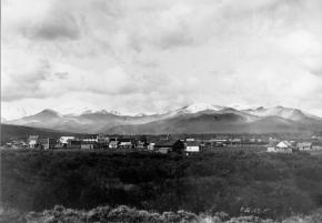
Travel across various passes of the Continental Divide occurred long before white men showed up. Indeed, as anthropologist James Benedict wrote c. 1975, some 10,000 years ago, prehistoric Indians camped, hunted, and built hunting walls on the upper reaches of Rollins Pass, as well as moving in and out of Middle Park for the warm summer months.

Historic Indians followed the same paths. In the earliest days of non-Indian access, a particular pass at the head of Boulder Creek was dubbed Boulder Pass. Capt. Jacob Bonesteel, including wagons, made the first recorded crossing by a white man at this point in April 1862. Three years later, a group of Mormons brought wagons over this route and a year later, promoters of new roads into Middle Park brought in many wagons and livestock.

In fact, tourists were starting to enter the park by a number of routes, and one of them, Samuel Bowles, who wrote a fascinating account of his trip, including his return to Denver via Boulder Pass. Interest was growing rapidly for a road over the Divide, into Hot Sulphur Springs, and on into Utah. One promoter, John Quincy Adams Rollins, from New Hampshire, teamed up with William N. Byers and Porter M. Smart to carry this project through. Rollins was interested in crossing the Divide; Byers was promoting the Springs; Porter wanted to develop the valley of the Middle Yampa. All three were pushing to have Middle Park officially named as Grand County, a challenge finally accomplished in 1874. So Rollins and associates started his road, reaching the top in 1873.

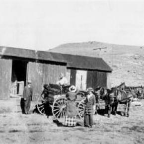
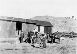
That next winter, they publicized this access and in June, Jimmy Crawford brought his family and wagons to Rollinsville and thence to Yankee Doodle Lake, ready to cross the pass now named Rollins Pass by the developer. But the road ended, and they found Rollins' men still hacking the road out of the granite! Jimmy and his crew found it necessary to leave their wagons and help. Finally, on June 10th, the family was able to head for the top. Jimmy borrowed two yokes of oxen, hitching them to mules, and then to his horse. The road was so rough that the procession could proceed but a few feet before having to rest. The family itself climbed on foot. At the summit, they discovered only a rough swath cut down through the trees on the western side. The "road" dropped down between the lakes and followed Ranch Creek to its junction with the Fraser River.

Rollins quickly realized that Berthoud Pass, which also opened in 1874, was superior to his own pass for wheeled vehicles, so he determined to hedge his bets. He initiated the first mail service into the county in 1873. He also built a commodious hotel where his road joined the Berthoud Pass road at the confluence of Crooked Creek and the Fraser. He called it the Junction House. Next, he proposed to the builders of Berthoud Pass that they form a joint ownership of the two roads between Junction Ranch and the Springs. Tickets would be issued for both routes and revenues would be shared. The two companies would build a bridge over the Grand at Hot Sulphur Springs. He even buttered up his rivals by complementing their work. All this was accomplished, although the mail route soon moved to Berthoud Pass, because of the severe winters on Rollins Pass.

The bridge was started in November 1874. From the beginning, Rollins' road was preferred for trailing livestock, because there were fewer problems with heavy timber and bogs. For years, the Church brothers, George and John, who introduced the Hereford breed into the county, trailed their cattle for summering in what became known as Church Park. However, tourists such as Irving Hale still drove wagons over Rollins Pass in 1878. About 1880, interest burgeoned for bringing a railroad up South Boulder Canyon and through a tunnel near Rollins Pass. Numerous surveys were completed all along the area. David Moffat settled on Rollins Pass for the tunnel site but decided first to put a temporary line over the top.

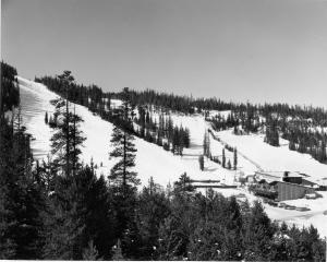
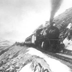
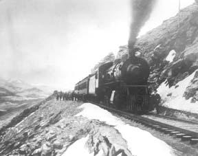
Thus, in the summer of 1903, a formal contract was let for work up and over the Pass itself. By 1904, the workers reached Arrowhead and they also built a work station on top, called Corona Station, or "crown of the mountain." This railroad construction town of Corona, located at over 11,600 feet at the top of Rollins Pass (first called Boulder Pass) along the Continental Divide was the highest railroad station in the world. It became obvious by 1905 that the Corona area would require snowsheds if trains were to travel, even irregularly, during the winter. Still, word got out of the spectacular splendor of Rollins Pass and tourists flocked in on summer train excursions, sometimes stopping on top, sometimes going as far as Arrow.

In 1913, a fine hotel was built next to the rail facilities. Because Rollins Pass was right in the middle of severe weather patterns, a weather station was built on top, as well as one down at Sunnyside. In 1915, Rollins Pass was actually proposed to be the south boundary of a proposed "Estes National Park." Later, on the National Historic Register, the district was listed in 1997 as the Denver, Northwestern and Pacific Railway Historic District--Rollinsville & Middle Park Wagon Road. It was also identified as the Rollinsville and Middle Park Wagon Road; Boulder Wagon Road, Rollins Pass, and Rollinsville area. In 1956, Governor Steve McNichols had presided at the official re-opening of the four percent grade to vehicle traffic over Corona Pass, expressing the hope that the route would someday be paved. The Colorado Game and Fish Department and the U.S. Forest Service made additional improvements, and the Arapaho and Roosevelt National Forests put out a 24-page booklet titled "The Moffat Road: A Self-Guiding Auto Tour."

The road crossed two of the original railroad trestles near Corona but those trestles, even if reached by 4-wheel vehicles, were crumbling and could no longer even be crossed safely on foot. The current self-guided auto tour refers to Rollins Pass, as well as the Moffat Road and the Boulder Wagon Road. Corona Station and Hotel are discussed. In 1979, a portion of the auto road over Corona Pass was permanently closed because of a cave-in of the "Needle's Eye," a tunnel located before the trestles heading west from the Moffat Tunnel's East Portal. The tunnel reopened on July 3, 1988, thanks to efforts of the Rollins Pass Restoration Association on both sides of the Divide, with the cooperation of the U.S. Forest Service, Colorado History Society, and Boulder, Grand, and Gilpin Counties. It then closed once more when another rockfall hit the tunnel on July 15, 1990. The RPRA is continuing its efforts for re-opening. The noted photographer, Charles McClure, took many outstanding photos of the Rollins Pass road.

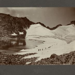
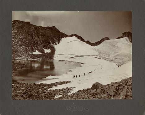
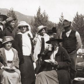
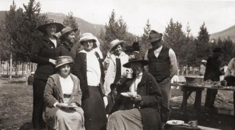
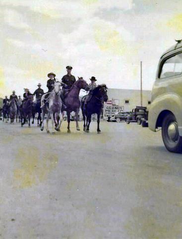
One, titled "Group on Rollins Pass, shows well-dressed men and women stand on a snowfield making snowballs on Rollins Pass, Moffat Road, Boulder or Grand County, Colorado; probably on Denver, Northwestern and Pacific excursion train. Date: between 1904 and 1913 near Corona Station." Another photo shows a "30 ft. snowcut on Rollins Pass, Moffat Road photo. Denver and Salt Lake Arrow passenger car is parked east of Corona snowshed by the thirty foot snowbank cut, Rollins Pass, Colorado; it shows men, women and railroad employees posed behind train, on the roof and on the snowbank and a standard gauge track. Date: between 1904 and 1915." A sign at the highway turn onto the Moffat roadbed says: The Moffat Road "Hill Route" Also called "Corona Pass Road", this road over the Continental Divide was the original "Hill Route" of the Denver, Northwestern & Pacific Railway built by David H. Moffat in 1903. It crosses Rollins Pass at 11,666 feet elevation. On top of Rollins Pass, a sign says: Elevation 11, 660 feet, John Quincy Adams Rollins established a toll wagon road through this pass in the mid 1870's. David H. Moffat's Denver, Northwestern & Pacific Railway crossed the Continental Divide at this point in 1903.

First known as Boulder Pass, then Rollins Pass, the railroad workers dubbed it "Corona", the crown of the "Top of the world." A railroad station, hotel, restaurant and workers' quarters existed here until 1928 when the railroad was abandoned due to the building of the Moffat Tunnel. Identifications in various trail and geographical guides say: Rollins Pass (el. 11,680 ft) is a high mountain pass in the Rocky Mountains of north-central Colorado in the United States. The pass is located on the continental divide at the crest of the Front Range southwest of Boulder, at the boundary of Grand County, Colorado and Boulder County, Colorado. Rollins Pass (a.k.a. Corona Pass) sits approximately 5 miles east and above the popular ski areas around Winter Park, between Winter Park and Rollinsville. The pass is traversed by an unpaved road, mostly the former roadbed of the Denver and Salt Lake Railway which abandoned the route in 1928 when the Moffat Tunnel opened to replace it. Railroad advertising called this the "Top O' the World" and it referred to the Moffat Route over the continental divide and the Rocky Mountains. Rollins Pass was the primary travel route west from Denver until an easier road over Berthoud Pass was constructed. The Denver, Northwestern and Pacific railroad laid its tracks across the pass in 1903-1904 and established a Depot at Corona on the crest. It can be noted that in R.C. Black's Island in the Rockies, the term "Corona Pass" was mentioned one time, on p. 351; the terms "Corona Station" or "Corona Snowsheds were used. In Dismantling the Rails That Climbed, Rollins Pass was used, the Corona hotel, and just once, Corona Pass; 1936.

In Maggie By My Side, it was Boulder Pass and Rollins Pass. In Rails that Climbed, Rollins Pass, the Corona shed, weather at Corona, Rollins Pass Snow Shed, other references to Corona as a site. In Guide to the Colorado Mountains (Orme) , they speak of the Corona Trail to Rollins Pass. High Country Names (Ward) used Rollins Pass entirely. Only Hiking Grand County, Colorado, published 2002 by Carr speaks of Corona Pass, with reference to Rollins Pass (near the town of Corona), Moffat Road. The term "town" might be questionable; there was only a small restaurant, workers quarters, railroad offices, and in 1913, the hotel. Current maps, USFS and the Grand County Trail Map, show Rollins Pass, with Corona at the side as being a site. The use of "Corona Pass' seems to be a rather recent innovation that has come into being with tourism efforts in the upper Fraser Valley. Rollins Pass From Island in the Rockies p. 45 Rollins Pass was originally known as Boulder Pass, first recorded being crossed by whites, by Capt. Jacob Bonesteel in April 1862. Their supplies were carried in wagons. A second organized party went over the same pass in 1865. In 1866, promoters of access into Grand County brought many wagons and livestock over Boulder Pass.In 1867, Samuel Bowles and a group returned home to Denver via Boulder Pass. In 1873-74, two roads were proposed into the county, one of Berthouds pass and one over Boulder Pass. This was the same time that the county was named "Grand". J..A Rollins and his associates started the road and reached the top of the pass in 1873, at which time they envisaged a road from HSS into Utah. The first wagons went over in June 1874. The western descent was so bad that it never was much patronized by wheeled vehicles, instead becoming primarily used for trailing of cattle. At this time the name Boulder Pass disappeared from maps and Rollins Pass became the official name. p. 85. p. 80 Lots of schemes to build roads into GC, but of all the schemes for transport, only one, the Rollinsville and Middle Park Wagon Road showed any promise. T

hat was designed by John Quincy Adams Rollins, from NH, a gifted promoter, a son of a clergyman, second of 19 children. He was a farmer, miner, freighter, road bulder, and platter of towns. He was perhaps the most accomplished billiard player west of the Mississippi. He was a Colorado resident at least by 1866. His finances were up and down, but he was tremendously strong. In December 1884, when he was 68, he thought nothing of a 3-day snow-clogged crossing of the Continental Divide. p. 85 Rollins was interested in MP as an investor and he was interested in extending his road into Utah.. At the same time, a Porter M. Smart was likewise excited about speculating in frontier projects and was working at developing the valley of the Middle Yampa. William N. Byers was busy planning for HSS. These three men launched at least two petitions, with more than 80 "residents" for creating GC. Grand County was created that year, 1874. p. 89 With the creation of GC, people began to consider the area more seriously. p. 92 There was no official mail into the county until 1873 when Rollins brought in the first US pouch over his pass. In May 1874, he built a commodious hotel at the confluence of Crooked Creek and the Fraser, known as the Junction House. p. 94 Rollins knew that the road over Berthoud Pass was superior to Rollins Pass; his main advantage was the railhead at Blackhawk.

So Rollins proposed a joint ownership and operation of the two roads for the line between Junction Ranch and HSS. Tickets would be issued for both routes and revenues would be shared. The two companies would build a bridge across the Grand at HSS. Rollins even complimented the Berthoud work. This merger was completed soon. p. 104 This bridge was started in November 1874. p. 108 A mail contract was made in July 1875 for once a week delivery over Rollins Pass, but conditions were so severe that the route was changed to Berthoud Pass. p. 110 From the beginning, Rollins Pass was used in preference to Berthoud Pass for trailing livestock, because there were fewer problems with timber and bogs. However, late spring snowdrifts were a problem, so 20-30 horses were often brought along to break trail. The Church brothers, ?George and John, summered their cattle in what became known as Church Park and dug the Church Ditch. They also introduced the celebrated Hereford breed into GC. p. 170-171 As interest in bringing a railroad into and through GC developed, about 1880, various stockholders proposed to build up South Boulder Canyon to Yankee Doodle Lake and start a tunnel near Rollins Pass. Nothing came of the first attempts but by the end of July 1881, numerous surveys had been made for that tunnel. p. 238 Cattle was still being trailed out via Rollins Pass up to the turn of the century. p. 258 David Moffat and Horace Sumner, his chief engineer, in the fall of 1903, were planning the tunnel for future excavation; but in the meantime a temporary line was planned for crissing Rollins Pass, at 11,640 feet. p. 264 A formal contract was let for the work over Rollins Pass in August 1903. The loftiest sections were started first, and the first cuts at the top were nearly finished by the 26th of October and tunneling started at Riflesight Notch. As snow came, work slowed to a standstill. p. 265 Work in 1904 was extremely slow until the end of August.

An encampment was built at Arrowhead and a station at the crest of the Divide was named Corona Station, where long snow sheds were built almost immediately. p. 267 Arrowhead was soon shortened to Arrow, when a post office was opened there in 1905. Travel on the grades, at 4-5% grades up over Rollins Pass was exceedingly difficult. p. 270 In 1908, word of the scenic splendor of Rollins Pass was becoming known world wide. Also, Rollins Pass and its "Corona station" were attracting the attention fo the US Weather Bureau, for the pass lay squarely in the center of the region of heaviest snowfall on the entire Colorado Continental Divide. p. 344 A terrible winter in 1909 made people think that Rollins Pass was never going to be practical for the long term. Time and again freight and passengers were stuck on top at the Corona facility. In 1913, a $10,000 hotel was built at Corona next to the rail facilities. From Dismantling the Rails That Climbed p. 6 The railroad went from Denver to the top of Rollins Pass. p. 8 Snowsheds were built over the tracks at Corona and other strategic places in 1905. p. 12 The top was referred to as "Corona Pass" 1936. p. 16 Crews who were to removed tails and ties reached Corona at the top of Rollins Pass 1936. p. 20 Reference to the Corona hotel From Maggie By My Side p. 1 Jimmy Crawford heard that a man named John Quincy Adams Rollins was building a road over the range at a place called Boulder Pass. 1873 p. 9-14 June 1874 The Crawford family traveled to Rollinsville and then to Yankee Doodle Lake, where the road ended. Rollins' men were still hacking the road out of the granite. Jimmy and his crew helped. On the morning of June 10, the family started out to go over the rocks and up the mountain. Then he borrowed two yokes of oxen to his wagon, then mules, then his horse. The animals had to rest every few feet; the family climbed on foot. There was no shelter at the top. Rollins' men had done no work yet on the west side of the pass except to cut a rough swath down through the trees. The road dropped down along Ranch Creek. From Rails That Climb published 1950 p. 43 Leyden Junction to Tolland to Rollins Pass. P. 63-64 Many references to Tunnels as identifiers of location. p. 76-77, 78 reference to the old Rollins Pass toll road; first mention of the place called Corona- crown of the mountain. Most references are to Rollins Pass. The Corona shed is mentioned, p. 82. p. 83 Sunnyside water stop, Loop Trestle and Tunnel, Ranch Creek Trestle and water stop, Arrow. p. 95, 100- 101 It is eleven miles from Arrowhead to Rollins Pass. Rollins Pass-Boulder wagon road; other references p. 107 - 112 reference to Corona shed. Reference to pipe line to Corona; a number of comments to Rollins Pass p. 119 weather at Corona p. 120-121 Rollins Pass p. 151 Rollins Pass p. 182 photo of "Rollins Pass Snow Shed" "This Corona station burned one night." p. 188 photo of June at Rollins Pass p. 192-194 photos of Corona shed and other buildings; Rollins Pass p. 252 walking on top of snow shed at Corona p. 271- 272. 1910 Snowshed at Corona p. 312-314 Rollins Pass; Rollins Pass snowshed; Corona; Corona siding p. 324 Corona; Sunnyside weather report station p. 326 Corona sheds p. 333-335 Corona shed; references to "Corona" as a place From Guide to the Colorado Mountains published 1974 p. 54-55 Corona Trail, going from East Portal to Rollins Pass From High Country Names published 1972 p. 105 Irving Hale in 1878 drove his wagon over Rollins Pass, now nearly abandoned as a wagon road. p. 131 David Moffat decides to build a temporary line over Rollins Pass. p. 165 In 1915, Rollins Pass was proposed to be the south boundary of a proposed "Estes National Park". From Hiking Grand County, Colorado published 2002 p. 52 Trailhead on the "Moffat Road to Corona Pass". In same paragraph, it becomes Rollins Pass (near the town of Corona). On p. 54, reference to the Corona Road. On p. 57, map shows Rollins Pass with Corona marked as a "site." p. 56, reference to the old railroad bed used crossing the Divide at Rollins Pass, near the town of Corona.

Sometimes called Corona Pass. p. 60-61 Rollins Pass Wagon Road historical notes on JQA Rollins and how to find his wagon road over Rollins Pass, following Ranch Creek to Tabernash. p. 66 Rollins Pass (Corona) to Devil's Thumb From GCHA Journal The Journey p. 6 Rollins Pass used by Indians; comment in 1981 From GCHA Journal Middle Park Indians to 1881 p. 8 Archaic hunters camped in the Rollins Pass area; written mid-1970's The current maps, USFS and Grand County Trail Map, show Rollins Pass with Corona at the side as being a site. The Rollins Pass Restoration Association for many years, and currently, has been trying to open the road and Needles Eye Tunnel. The self-guided auto tour refers to Rollins Pass, as well as the Moffat Road and the Boulder Wagon Road. Corona Station and Hotel are discussed. On the National Historic Register Denver, Northwestern and Pacific Railway Historic District--Rollinsville & Middle Park Wagon Road (Boundary Increase) ** (added 1997 - District - #97001114) Also known as Rollinsville and Middle Park Wagon Road;Boulder Wagon Road;R Rollins Pass, Rollinsville Corona Station and Hotel The railroad construction town of Corona, Colorado, located at over 11,600 feet at the top Corona Pass (first called Boulder Pass) along the Continental Divide was the highest railroad station in the world. It was situated on an old Native American trail, the same trail it is believed the Mormons traveled on their way to Utah. The road was improved by the U.S. Army, then further improved in 1866 by General John Q. Rollins, for whom the pass and the town of Rollinsville were officially named. Because of the high drifts of snow, the pass was only open from around July to the first big snowstorm two or three months later. In 1956, Governor Steve McNichols presided at the official re-opening of the four percent grade to vehicle traffic over Corona Pass, expressing the hope that the route would someday be paved. The Colorado Game and Fish Department and the U.S. Forest Service made additional improvements, and the Arapaho and Roosevelt National Forests put out a 24-page booklet titled "The Moffat Road: A Self-Guiding Auto Tour."

The road crossed two of the original railroad trestles near Corona but those trestles, even if reached by 4-wheel vehicles, are crumbling and can no longer even be crossed safely on foot. In 1979, a portion of the auto road over Corona Pass was permanently closed because of a cave-in of the "Needle's Eye," a tunnel that came before the trestles on a westward drive from the Moffat Tunnel's East Portal area. The tunnel reopened on July 3, 1988, thanks to the efforts of the Rollins Pass Restoration Association with the cooperation of the U.S. Forest Service, Colorado History Society, and Boulder, Grand, and Gilpin Counties. It was then closed once more when another rockfall hit the tunnel on July 15, 1990. John K. Aldrich is a geologist, lecturer, and author whose "Ghosts of . . . " books and accompanying topo maps are a boon to hobbyists, explorers, and those interested in Colorado mining history. Date: 02/04/08 05:13 Rollins Pass Milepost 16 Corona Station. Picture 6 below, is DPL photo X-7388. "Title: Corona, Colorado, interior of snowshed. Summary: Passengers stand next to the covered train depot at Rollins Pass, in Corona (Grand County), Colorado. The tracks of the Denver, Northwestern & Pacific Railway are in the foreground. The depot is constructed of logs, and the roof of the snowshed is upheld by timbers. Sunlight streams through the opening at the end of the snowshed. Date: (between 1904 and 1913). Source: E. T. Bollinger from W. I. Hoklas." Picture 7 below, is DPL photo MCC-454A. "Title: Group on Rollins Pass. Summary: Well dressed men and women stand on a snowfield making snowballs, Rollins Pass, Moffat Road, Boulder or Grand County, Colorado; probably on Denver, Northwestern and Pacific excursion train. Date: (between 1904 and 1913). Creator: Louis Charles McClure 1867-1957. Picture 8 below, is DPL photo MCC-624. "Title: 30 ft. snowcut, Rollins Pass, Moffat Road photo. Summary: Denver and Salt Lake Arrow Turn (passenger car) parked east of Corona snowshed by thirty foot snowbank cut, Rollins Pass, Colorado; shows men, women and railroad employees posed behind train, on roof and on snowbank and standard gauge track. Date: (between 1904 and 1915 The highway sign says The Moffat Road "Hill Route" Also called "Corona Pass Road", this road over the Continental Divide was the original "Hill Route" of the Denver, Northwestern & Pacific Railway built by David H. Moffat in 1903. It crosses Rollins Pass at 11,666 feet elevation. On top of Rollins Pass, a sign says: Rollins Pass Elevation 11, 660 feet John Quincy Adams Rollins established a toll wagon road through this pass in the mid 1860-s. David H. Moffat's Denver, Northwestern & Pacific Railway crossed the Continental Divide at this point in 1903. First known as Boulder Pass, then Rollins Pass, the railroad workers dubbed it "Corona", the crown of the "Top of the world." A railroad station, hotel, restaurant and workers' quarters existed here until 1928 when the railroad was abandoned due to the building of the Moffat Tunnel. Rollins Pass Elevation 11,680 ft (3,560.1 m) Traversed by Unpaved road Location Boulder_County,_Colorado / Grand,Colorado Rollins Pass (el. 11,680 ft) is a high mountain pass in the Rocky Mountains of north-central Colorado in the United States. The pass is located on the continental divide at the crest of the Front Range southwest of Boulder at the boundary of Grand_County,_Colorado and Boulder County. Sign that sits on top of Rollins Pass Rollins Pass (a.k.a. Corona Pass) sits approximately 5 miles east and above the popular ski areas around Winter Park, between Winter Park and Rollinsville. The pass is traversed by an unpaved road, mostly the former roadbed of the Denver and Salt Lake RailwayDenver_and_Salt_Lake_Railway which abandoned the route in 1928 when the Moffat Tunnel opened to replace it. Rollins Pass Railroad advertising called this the "Top 'O the World" and it referred to the Moffat Route over the continental divide and the Rocky Mountains. Rollins Pass was the primary travel route west from Denver until an easier road over Berthoud Pass was constructed. The Denver, Northwestern and Pacific railroad laid its tracks across the pass in 1903-1904 and established a Depot at Corona on the crest. David Moffat planned to replace the "Hill Line" with a tunnel through James Peak within a few years of the railroad construction. However, he never could obtain financing for the tunnel due to the inability of the railroad to make a profit and opposition from competing railroads such as the Denver and Rio Grande. The D&RG saw the line as a threat. But, in the far future the construction of Moffat Tunnel would turn out to be the D&RG's saving grace.

The trip up Rollins Pass was a favorite of summer tourists looking to enjoy the mountain scenery. It was heavily promoted by the railroad with picnic and wildflower picking excursions. Sights along the line were made famous by postcards containing the photos of L. C. McClure. At last the route surmounts the crest of the Continental Divide and takes quick refuge on the top at Corona. At elevation 11, 660 this is truly the famous Top O' the World and one of the highest railroad passes in the world. Due to the great height and nature of the Rocky Mountains, the entire railroad complex was completely enclosed in giant covered snow sheds.

Libraries