People Articles

Ranger Stories - Wildlife in Middle Park

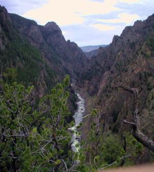
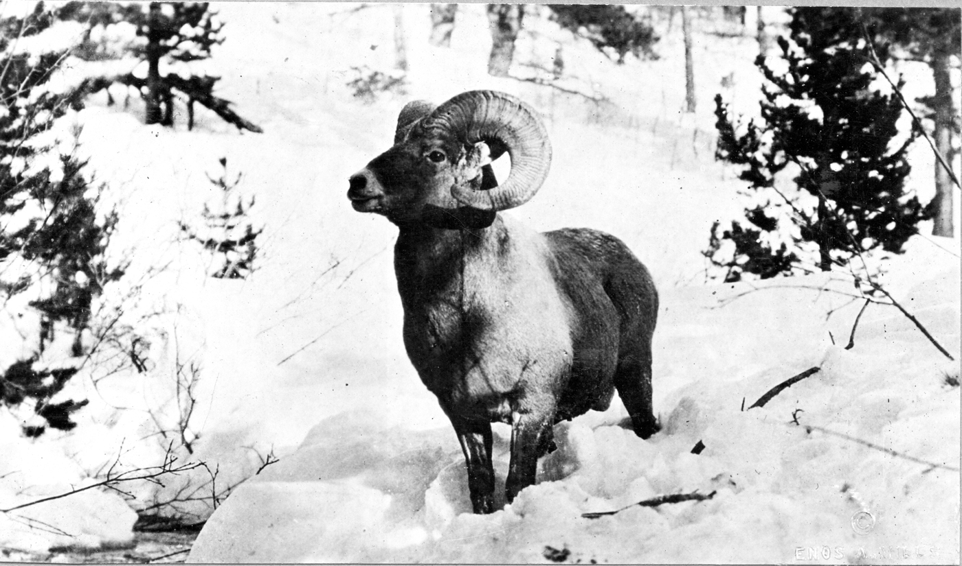
“He spent the winter of 1886-87 in Middle Park, Colorado … and succeeded in killing three grizzlies, two mountain lions, and a large number of elk, deer, sheep, wolves, beavers and many other animals.” The above is one of the earliest reports of wildlife in Middle Park. It comes from John Wesley Powell in his book The Exploration of the Colorado River and its Canyons, where he describes local trading post owner Jack Sumner, who accompanied him on their 1869 trip through the Grand Canyon. Forest Service wildlife reports date back at least to 1913. At the end of each year rangers and forest supervisors were required to submit a report on the status of wildlife in their districts and forests. Thanks to the diligence of Sulphur Ranger District wildlife biologist Doreen Sumerlin and her predecessors, those original reports dating from 1913 to 1939 have been retained and protected. They were scanned by the Grand County Historical Association and added to the permanent collection of historic documents in the Pioneer Village Museum. These reports provide fascinating insight into the perceived issues and approach to wildlife management practiced by wildlife managers in previous decades as contrasted with wildlife management today. In the early days of the Forest Service and state wildlife agencies the focus was on providing game for hunters – elk, deer, grouse – and removing any predators perceived to be a threat to those species and to ranchers’ livestock. The following excerpts from ranger reports exemplify this approach. 


Ranger Stories: Wildlife in Middle Park Wolves October 29, 1913, Only three wolves have been reported on the Forest …. An especial effort will be made by the Forest Hunter to exterminate these three and it is hoped that losses to the stockmen in North Park from this source will cease. Wolves are on the decrease and it is felt that the total extermination will occur within a few years. -Alva Simpson, Forest Supervisor October 23, 1914, Only one wolf is now reported – the famous “Three Toes” upon whose head an enormous bounty is placed. Being a male, no increase will result unless he finds a mate. The loss from this one wolf is enormous, one cattleman losing last winter eleven head of blooded stock valued at $1,000 or more. Although very wise, the end will come and it will be a pleasure to report his death. -Alva A. Simpson, Forest Supervisor


October 29, 1913, Only three wolves have been reported on the Forest …. An especial effort will be made by the Forest Hunter to exterminate these three and it is hoped that losses to the stockmen in North Park from this source will cease. Wolves are on the decrease and it is felt that the total extermination will occur within a few years. -Alva Simpson, Forest Supervisor October 23, 1914, Only one wolf is now reported – the famous “Three Toes” upon whose head an enormous bounty is placed. Being a male, no increase will result unless he finds a mate. The loss from this one wolf is enormous, one cattleman losing last winter eleven head of blooded stock valued at $1,000 or more. Although very wise, the end will come and it will be a pleasure to report his death. -Alva A. Simpson, Forest Supervisor


October 12, 1914, Horseshoe Ranger Station, Scholl, CO, There are a few lynx on the district. Gus Champier told me that he trapped three last winter. One was seen this fall near the head of Lost Creek and I also saw tracks in the snow last week where three had gone along the Williams Peak trail where it crosses Lost Creek. -Lewis G. Davis, Asst. Forest Ranger Magpies November 13, 1917, Hot Sulphur Springs, Another menace to them (grouse) and to all song birds is the magpie. In June of this year I noticed four magpies drive a grouse hen from her nest then peck and eat the eggs. If the coyotes and magpies could be exterminated it would help to increase game birds of all kinds. Magpies, hawks, and eagles should be killed whenever the chance comes. -No name, Forest Ranger Bears October 13, 1915, Scholl, CO, The bear are getting to be quite a common thing in this part of the country. I have seen four myself this year, 1 black and 3 brown, besides those trapped by Almirall and his hired help. They got 2, 1 black and 1 brown. Will Darling also trapped a silver tip last spring in Darling Creek. Henry Wilson roped a small brown bear last week and he has seen several on the Muddy while riding for cattle this summer. -Lewis G. Davis, Asst. Forest Ranger


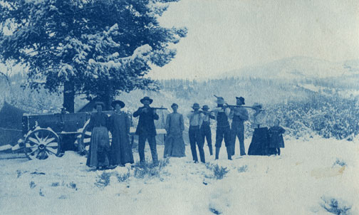
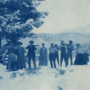
Coyotes October 15, 1915, Hot Sulphur Springs, A substantial bounty should be placed on coyotes. As it is now, everyone kills them when the opportunity occurs, but a substantial bounty would make it worthwhile for a man to carry a gun on his saddle always, thus being prepared to kill them at all times. The extermination of this, our most destructive predatory animal, would soon result in a great increase of game. -Bertram A. Goodman, Assistant Forest Ranger Fish October 23, 1914, All the streams have been stocked in the past but even with the heavy stocking most of the streams are fished out. This is the direct result of the tourist industry and the continuance of the industry requires the constant stocking of the streams. -Alva A. Simpson, Forest Supervisor Game Wardens As is the case today, the State of Colorado is responsible for managing the wildlife while the Forest Service is responsible for managing the habitat – the land – on national forests. Apparently, there were issues! October 29, 1913, Effective game protection cannot be had under the present system of enforcement of the law. …The average settler is in favor of game protection, but will not exert himself to see that protection is given when the men paid by the State to protect the game show no other interest than to draw their salaries: I understand that in the City of Denver there are five paid, year-long game wardens. It is obvious that game animals will be not be found in the City unless they appear on the table at a banquet. -Alva Simpson, Forest Supervisor October 15, 1913, The present game laws in my opinion do not protect the game. A person can go in almost any portion of the state and ask for the game warden either deputy or special, and nine cases out of ten if you should ask him the road to some place off the main traveled road, he does not know, he has never been off the main road. -W. M. Leahy, Asst. Forest Ranger October 23, 1914 A yearlong Game Warden has been appointed but his effectiveness is in doubt. Take fifty years, 200 pounds and a 650-pound buckskin pony and you have our representative of the Game Laws. What is needed is a young live man used to the trails and forest byways—endured to the hardships— and with Civil Service standing and a chance for promotion ahead of him. Then our law would be respected, not as a bound volume for winter reading but through the arm as typified by its successful enforcement. -Alva A. Simpson, Forest Supervisor Today, due to requirements of important laws such as the 1973 Endangered Species Act and the 1976 National Forest Management Act, the Forest Service and other land management agencies recognize the value of all wildlife, fish and plant species and work cooperatively to carry out management practices to sustain them.

By Dan Nolan

Coyote hunters Chet McQueary and Pom Ainsley


Coyote hunters Chet McQueary and Pom Ainsley

 
Redwood Fisher
Redwood Fisher

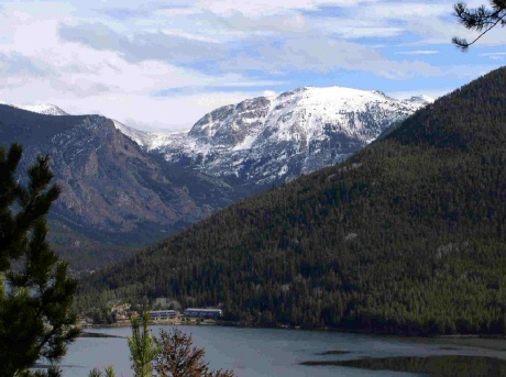
Article contributed by Corinne Lively

There were two Redwood Fishers, grandfather and grandson, who made significant contributions to the development of the Grand Lake area. 

One of the earliest pioneers was the senior Redwood “Woody” Fisher, born in Urbana, IL in 1839.  He learned surveying skills in New Jersey, and received a degree in Civil Engineering in New York City, where he met his future wife, Louise Perrenoud.  He arrived in Denver in June 1860 and borrowed money to purchase his first surveying instruments.  His bride to be, her two sisters and widowed father arrived in Denver in July 1862 in a mule drawn ambulance. They had traveled for six weeks from Omaha to deliver the vehicle which was used as an ambulance and hearse.  The first marriage license in Denver was issued to Woody and Louise, and their wedding took place May 6, 1865. 

The day after his marriage to Louise, Woody joined General Hughes and E.L. Berthoud as Chief Surveyor in building the wagon road from Denver to Provo, Utah over Berthoud Pass.  The expedition followed a route laid out by Jim Bridger. 

Woody held the offices of Denver city and county surveyor and county commissioner.  He was foreman of Hook and Ladder Co. #1, and helped fight many Denver fires. 

In May 1870, Woody was killed attempting to stop a runaway team of horses at the corner of California and 14th Streets.  While trying to save the lives of several children, he fell and the wagon wheels ran over him.  Woody left his wife with three children, Louise, Charles and Ella.  He is buried in Riverside Cemetery.

Redwood must have spoken in glowing terms about his time in Grand County since his son Charles, only two when his father was killed, spent most of his life near Grand Lake, built a summer home on the North Inlet below the Rapids Lodge, purchased 160 acres on the east side of the Colorado River from the Fred Selak estate.  He died here in August 1945.  Charles and his wife Sara had a son in May 1907, whom they named Redwood.

The junior Redwood “Red” Fisher also spent most of his life in the Grand Lake area.  He was an early Park ranger and helped stock many of the high lakes on horseback.  After his marriage to Helen Schultz in 1928 he started ranching below the present Shadow Mountain dam on land purchased from Mrs. Cairns.  He later acquired the 7V/ on Stillwater Creek.  He was President of the Colorado Dude Ranch Association in 1947 and traveled to conventions in Chicago and elsewhere promoting Colorado’s guest ranches with displays of fancy roping and riding.  His own dude ranch, Fisherancho, was on the land below Shadow Mountain Dam and served guests until the 1950s.  The barn still stands, and is now part of the Arapahoe Recreation Area. 

Sources:
Lela McQueary, Widening Trails, World Press, 1962
Middle Park Times, August 12, 1945 and May 6, 1993
Colorado Families: A Territorial Heritage, CO Geneological Society, 1981
Brand Book, Middle Park Stock Growers Assn.
BLM General Land Office Records
Conversations with local decendant Toots Cherrington


Rowley & Just Homesteads

Karl and Adella Just homesteaded on Pole Creek in the Fraser River Valley in 1896.  Della was the daughter of Henry Lehman, who had, himself, homesteaded on the upper Grand River about 1880.  Karl and Della worked hard, adding to their property until by the late twenties, they had the largest holding in the valley. 

This lovely ranch was where Snow Mountain Ranch is now, and their log home still stands there even today.  Their several children homesteaded in their own rights.  Della and her son Alfred had what is known as the Rowley homestead, (now part of the Y-Camp) as well as what currently is the Winter Park Highlands.  Son Rudy and his wife Clarabelle ranched part of the original Just property on Pole Creek where they watched over his mother.  Another daughter married one of the Daxton boys and their spread was on Crooked Creek.

Until the 1950's, just beyond Tabernash on the north side of the highway at the foot of Winter Park Highlands stood one of the original log homes of this family. In fact, this house appeared in a 1952 movie called "On Dangerous Ground", starring Ida Lupino, Robert Ryan, and Ward Bond.  It was torn down some years later and a modern house built there.

Life was hard for ranching pioneers, perhaps hardest of all for the women, for they worked in the fields and of course, did all the work of the house as well as much of the garden work.  Little Della raked hay during the season, hoed gardens, hauled water, fished, sewed, and cooked.  She was tough.  The bright spots were when rare visitors stopped by, or as the population increased, dances were held in one town or another.

It was a given that the Just home, like those of most pioneers, had no indoor plumbing.  Nobody expected it and nobody complained.  However, by 1957, Della Just was in her nineties.  Karl was long gone.  Her children decided that she should have indoor plumbing after all these years, and they heard that young Dwight Miller had a brand new backhoe.   When they called, Dwight was pleased at the thought of doing such a useful job.

He brought his machine out to the ranch and prepared to get to work.  He discovered, however, that there was disagreement on this bright idea.  Della thought the notion was silly.  "I've lived all these years with an outhouse and I don't see any reason at all to change!"  

Back in those days, temperatures were very much colder than those currently expected.  Forty and fifty degrees below zero were not unusual at all.  But that old lady didn't mind this.  (No doubt, there were chamber pots available for the worst weather.)

Della's children, themselves no longer young, won out, and Dwight dug the trenches and the septic tank hole and laid the pipes.  We never heard whether Della got used to such luxury or not, but we know that Rudy and Clarabelle agreed that moving into the modern world was a good idea!


Rundell & French - Two families of the Sheephorn

October 2009

Here we have a story of two families, who became intertwined in a far away place where there weren't too many people. In fact, there was only a handful.  Three young fellows, the Rundell boys, came from Wisconsin about 1880, to settle on the Sheephorn, an area in the very southwest corner of Grand County.

Al, the oldest brother, chose land on the Upper Sheephorn.  While he was at it, he established a much-needed ferry across the Grand River at today's Rancho Del Rio.  His brother Clarence homesteaded land on the same stream some two miles above the Midland Trail, known to us as the Trough Road. The only home he could afford for a couple of years was a dugout under the creek bank.  That tended to be damp and dingy, but Clarence hung in.  Finally he was able to build a cabin uphill from the stream. Newspapers used as insulation on his cabin walls show the year to be 1882.  Clarence was pleased with his house.  "Now I feel I've really put down roots and am here to stay!" he exclaimed.

Their young brother, Ernest, was frail, for he had suffered all his life from lung trouble.   Still, he loved working with Clarence.  One summer, they were digging a water ditch near Azure, on the Grand, above Radium; Ernest caught pneumonia and died. The poor boy was only about sixteen. Clarence never got over his brother's death and he gave land for a cemetery, where he buried Ernest, the first person there.

The second family were the Rundell boys' neighbors, Charlie French and his older brother, Harry, Jr. who had "hit town" from Iowa just about the same time.  Harry homesteaded upstream from Clarence and anticipated ranching.  By and by, though, Harry remarked to Charlie, "I've discovered I'm not much of a hand at ranching and besides, my land isn't very fertile.  I think I'll sell it and become a U.S. Forest Ranger instead.  If they'll have me." He easily passed the test and soon transferred to the little community of Azure.

Now, Charlie French was a wonderful musician, a whiz at playing the fiddle.  He missed making music with their sister Phoebe.  "You know, Harry," he said one day.  "I'd really like Phoebe to come out and see this country. I'm sure she'd like it.  And besides, we could play together again."

He urged her several times to come visit.  At last she agreed, traveling by train to Leadville, then to Wolcott.  About then, Charlie started to worry.   "Phoebe's only 18," he thought, "and she's such a lady. Is it proper to expect her to ride sidesaddle all the way in from Wolcott?"  He stopped by to see Clarence Rundell.  "Clarence, do you suppose you could take your buggy to Wolcott and pick up our Phoebe?"  He explained the circumstances. "Why, I'd be delighted," answered his friend.

It was a happy development.  At the station Clarence saw a lovely young woman, tall and slender, obviously well-educated.  He soon found she had a beautiful soprano voice and was an accomplished musician who could play both piano and organ.  He took to Phoebe right away, and she, to him.  It wasn't long before the two decided to marry.

Now the French boys' parents, Harry, Sr. and Mary, sold their Iowa farm about now and homesteaded at Azure, to be near their boys, even though Charlie left the country soon after.  Here the old folks remained for many years.  They also had some land up the Little Sheephorn, which they gave Phoebe as a dowry, when Clarence and Phoebe decided to wed.  Shortly after, the happy young couple married and made the little cabin their home.

Their three children were born here, Ernest, named after the brother who died, Marie, and Helen.  Clarence worked very hard, ranching in the summer and cutting logs in the winter.  The young folks were thrifty.  In 1908, Clarence sold his homestead to a Swiss newcomer and bought land above his original site. By 1912, Clarence and Phoebe built a fine three-story house, complete with beautiful hardwood floors.  It was wonderful place to raise the children.  "This will surely be our home forever!"

Harry French, Sr., died in 1924.   "Mother," invited Phoebe, "move in with us, since you're alone now." Mary did this, but then she returned to Iowa to stay with her sister, until her death.  The French name continues on, however, for there are two French Creeks in the Sheephorn area.

Finally, the Rundells decided to buy a home in north Denver and to invest in an apartment house.  All went well until 1928, when everything fell apart at the beginning of the Depression.   Clarence lost nearly everything. "Let's go back to the ranch, Phoebe," he said.  "I still have my 300-400 head of cattle; I know ranching and love it.  Let's go."  Thus they left city life and returned to their ranching roots.

Sheriff
Sheriff

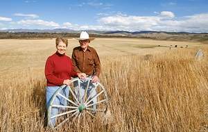
One of the oldest brands in Colorado still in use by the same family is the Bar Double S brand of the Sheriff Ranch near Hot Sulphur Springs. The current owners of the ranch are John Brice and Ida Sheriff. In 1863, Matthew Sheriff of Keithsburg, Illinois came to Colorado to search for gold in the California Gulch, near where Leadville would be established. Mathew was dismayed by the gray mineral which consistently clogged the gold sluice, and gave up on his dreams of instant wealth to return to Illinois.

Many other miners also gave up mining for this reason, never realizing that the gray mineral was carbonite of lead, which was rich in silver. Mathew died in 1863 at the age of 40, leaving behind his wife Marietta and their 3 surviving sons, Burt, Glenn and Mark. In 1878, Marietta was inspired to return to Colorado in search of security and stability for her family. She spent some time in Leadville running a boarding house. Her sister was the wife of William Byers who was developing the Hot Sulphur Springs area so Marietta moved to the area to settle with her sons. In 1882 the family homesteaded three ranches of 160 acres each, proving them up and added a preemption right to another 160 acres.

Bert later moved to Denver and established a livery stable and Mark and his mother moved into Hot Sulphur Springs, while Glenn continued to work the ranch. Glenn married Alice Cleora Smith in 1886 and they had two surviving sons, Brice and Glenn Jr. Glenn Jr. was only 6 weeks old when his father died at the age of 33 of “brain fever” or diphtheria. Alice took the children back to her family in Iowa to raise them, but the boys returned to their Colorado ranch in 1910. Brice, who suffered from a back injury as a child, bought an abstract business in Hot Sulphur Springs and lived there with his mother for the rest of their lives.

Glenn Jr. continued to expand and develop the ranch and married Adaline Morgan in 1923. They had four children; Nona, John, Robert and Catherine. Glenn Jr. served Grand County as a Commissioner for 24 years and also as the County Assessor for 4 years. Glenn Jr.s, son John, took over the ranch and married Ida Marte in 1949. Ida’s family had homesteaded their own ranch near Cottonwood Pass. They have two children and continue to work the ranch to this day.

Sir St. George Gore
Sir St. George Gore

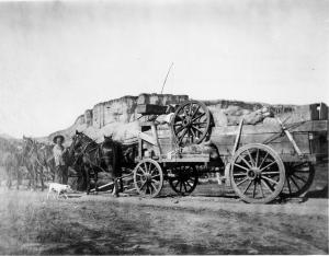
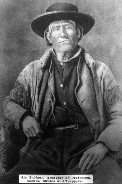
Sir St. George Gore was born in 1811 in County Donegal, Ireland, heir to an Irish baronetcy and was often referred to as Lord Gore.  He was educated as an aristocrat, never married, and never held public office.

He staged an expensive and expansive “American hunt,” leaving Westport, Missouri on June 6, 1854, with plans to hunt in the southern Rockies.  After spending some time at Fort Laramie, he arrived inMiddle Park. His guides were Joseph Chattillon and Jim Bridger. Gore had a entourage of 40 workers, 25 wagons, 24 mules, 112 horses , 3 milk cows and 14 dogs!

Loving his luxury, he slept in a brass bed, had nightly hot baths, and dines on superb food served on a lace tablecloth set with fine silver and crystal.  He often invited Bridger, who was illiterate, to dinner and awakened in the guide an interest in Shakespeare, which lead to the frontiersman hiring a boy to read the bard's plays to him.  

Described as "a good shot at rest but rather poor offhand" he nevertheless claimed to have killed 2,500 buffalos, 40 grizzly bears and countless deer, elk and antelope.   

Bridger led Gore to West Grand County, to the pass, range, and canyon that now bear his name.  The Indians were shocked at the expedition's wanton slaughter of every game animal in sight.

The expedition did not end until sometime in 1857, when Gore returned to Ireland and relative obscurity.  Not even a portrait remains of the infamous poacher.

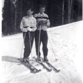
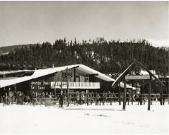
Skiing Legends Horace Button and Barney McLean
Barney McLean

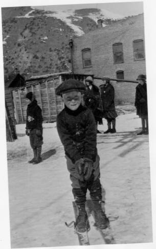
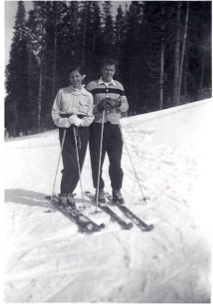
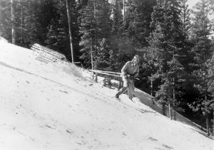
Horace Button was 10 years old when he saw the ski jump competition at the 1911 First Annual Hot Sulphur Springs Winter Sports Carnival.  A railway man noticed that Horace was spellbound.  The man asked Horace what he wanted to be when he grew up, to which Horace replied, “I want to be a ski jumper like Carl Howelsen.” The seed had been sown, and Howelsen taught Horace the skills of skiing.

Horace Button became an All-American Skier.  Winning awards over nationally recognized competitive ski racers.  The basic knowledge he learned from Howelsen was passed on which in turn sent Jim Harsh of Grand Lake, to be on the 1932 United States Olympic Nordic Combined team.  The Olympics were held at Lake Placid, New York. 

Barney McLean of Hot Sulphur Springs, became a champion following in the "ski boots" of Mr. Button. Horace would be waiting at the ski hill every afternoon, when school hours were over and he and Barney would schuss the mountain together.  Barney was a 9-time national champion, and a 3-time Olympian.  In 1948 he was Captain of the men’s alpine ski team that competed at St. Moritz, Switzerland. 

Horace Button continued to advise ski techniques to students of East and West Grand School Districts, helping them compete at the university or Olympic level.  They were; Dale Thompson, Wes Palmer, Zane Palmer, Landis Arnold, Todd Wilson, Kerry Lynch, Tim Flanagan, and many more.  Horace coached 12 national champions. 

Horace also was an accomplished artist. His specialty was carton ski scenes.  Tim Flanagan honored Mr. Button for his work with local youths and created the Horace Button Ski Foundation.

Horace Button, Jim Harsh, Barney McLean, and Carl Howelsen have been inducted into the Colorado Ski Hall of Fame. Barney McLean and Carl Howelsen are honored at The National Ski Hall of Fame.

The picture on the right is of Barney McLean at age 4, wearing a pair of skis his dad made for him. The photo was taken in Hot Sulphur Springs.

Smiths of the Blue River

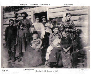
Frank John Smith was born October 5, 1852 in Granby, New York.  He married Elizabeth Olive Sanders, who was born in 1860 in Hannibal, New York.  They were married in 1878 in Hannibal and had two children Albert and Lelah.  Albert died as an infant in 1881.  In 1880 Frank homesteaded his ranch close to the Blue River and sent for his wife and baby daughter who came West by train to Dillon in the spring of 1883.

They had 10 more children, all born at the Smith Ranch, between 1884 and 1907.  As the boys grew into young men, they homesteaded additional acreage around the ranch.  The youngest son, Earl, operated the Smith Ranch until 1958, when it was sold to Ted Orr Sr. His son, Ted Orr Jr. and his wife, Virginia Smith (granddaughter of Frank and Elizabeth) operated the ranch until 1967, when it was sold to the Berger brothers.    

Stafford Family
Stafford Family

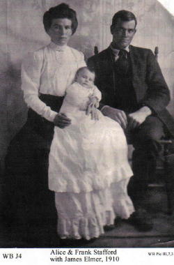
James "Jimmy" M. Stafford was born in 1849 in Wexford Ireland. Jimmy immigrated to Leadville in the 1870's to work in the booming silver mines. In Leadville, he met and married  Deborah Helen Acey (born 1846 in Trenton New Jersey) in 1880.  In the 1880's the couple moved to Dillon and then homesteaded the Stafford Ranch on the Blue River at Spring Creek Road. Jimmy built their home by hand carrying logs from Green Mountain.  They had one son, Frank Elmer Stafford, born in 1886. Jimmy and Deborah also operated the stage stop, boarding house and saloon called the "Halfway House" between Kremmling and Dillon on Highway 9.  It remained in operation until the stage lines ceased in the early 1900's and the buildings were dismantled in the 1940's.  

Frank went on to marry Alice Smith in 1909 and they had six children, including their first, a son, James Elmer, who died at age 8 in the worldwide flu epidemic of 1918. Frank and Alice built the Stafford General Store, directly across from the "Halfway House".  Frank was instrumental in installing the first telephone lines in the area and served as Grand County Commissioner from 1928 to 1936 and as County Commissioner from 1948 until his death from injuries in a car wreck in 1950.  Alice was called the "Blue River Belle" and kept the general store until 1960.  Alice lived in Kremmling until her death in 1969.  


Stephen Bradley
Stephen Bradley


Article contributed by Karen Wischnack


Born to a Wisconsin doctor in Chicago November 12, 1916 was one of seven skiing sons by the name of Stephen J. Bradley.  His talents in skiing showed up at a very early age.  By the time he was attending Dartmouth College his talents were apparent and was a top competitive skier.  He skied in the slalom, downhill, jumping and langlauf while on the college's team.  Steve then was called to serve his country during the World War II Army service.  After his discharge he then attended and coached skiing at Colorado University. 


In 1950 Steve became Winter Park's executive director.  During his employment at Winter Park he guided it from a four rope tow/three T-bar local ski area to a major resort of 770 acres with 13 chair lifts.  His brilliance in design led to the Balcony House, the Base Lodge which was one of the first ski area structures to utilize solar heating, the restaurant in the midway proved to be a model for the "scramble" system of food service and then there's the Mary Jane section of Winter Park which was another one of his talents.


Stephen was given the name "Father of Slope Grooming" in 1952 when he then invented the famous Bradley Packer-Grader when experimenting with slope grooming.  The invention was a one man gravity-powered slope grooming device which revolutionized the ski maintenance industry.  Nick-named "the Purple People Eater".  This machine was a mogul-cutting snow groomer that was 5-foot-wide corrugated culvert that a skier would drag down hill or as they said " A hardy mountain crewman" who risked his life by being devoured by the spinning rotor.  As skiing became more popular, skiers started demanding that the slopes be groomed.  Nature was no problem but not everyone wanted to ski moguls.  This Bradley Packer was a way to reduce the mogul's and keep snow on the trails by flattening the snow.  "It was a pretty scary thing" supervisors claimed.  Grooming was soon transferred to a line of tracked vehicles now known a "Snowcats". 


Stephen served as President of the NSAA (National Ski Areas Association) and helped organize Colorado Ski Country USA and the Colorado Passenger Tramway Safety Board before his death in Longmont November 13, 2002.  You can find him as an honored member of the Colorado Ski Hall of Fame and in the National Ski Hall of Fame.


Articles to Browse

Topic:

Regions

Grand County has a stunning variety of terrain, landscapes and distinctive regions.  The county encompasses 1869 square miles with almost 68% of the land is managed by the U.S. Forest Service, the Bureau of Land Management or the National Park Service. The Continental Divide marks the northern and western boundary of the county and the county is also the headwaters of the Colorado River.  Regions have been established by proximity to water sources (The Troublesome, The Muddy, The Blue, and Three Lakes) or by their geographic features (Middle Park, Church Park, and the Fraser Valley).

Topic: Indians

Tabernash

The unrest and hard feelings between the Indians and settlers in Middle Park gave rise to an inevitable conflict the last week of August, 1878. About forty Utes, led by Piah and Washington, started to set up camp in William Cozens’ meadow, near Fraser, taking fence poles to make fires. Cozens drove them off, telling them to replace the poles and leave. The Utes moved down valley about five miles to a spring not far from Junction Ranch (named for the junction of the Rollins Pass and Berthoud Pass wagon roads).

There, Johnson Turner, who leased that land, became increasingly uneasy as the Indians were drinking heavily and expressing anger that Ouray given away their land in treaties with the white man. They wanted Turner to pay them for the hay he was cutting. They tore down his fences for firewood, turned their 100 horses into his meadow, and set up camp. They also laid out a race track on drier ground about a mile way.

Turner complained to the sheriff, Eugene Marker, who rounded up a posse of men, intending to remove the Indians or at least convince them to move on. Accompanying him, on September 1, were Frank Addison, a transient prospector, John Stokes, T.D. Livingston, and Frank Byers.  The posse found only women and children at the camp, since the Ute men were at the race course. Marker, the sheriff, ordered the encampment searched for firearms and when the Ute men returned, an angry confrontation ensued. 

Tabernash and Frank Addison exchanged threats, and Tabernash jumped from his horse and snatched one of the guns piled on the ground. Frank Addison immediately shot him. Tabernash tried to pull his rifle from its scabbard, but that it became entangled, and Addison then fired twice more. Tabernash slumped over the neck of his pony, which ran away through the willows. Apparently Addison recognized Tabernash as the Indian responsible for the killing several of his companions while trapping furs on Grizzly Fork in North Park six years earlier. 

After this bloodshed, the posse persuaded the rest of the Utes to leave, after they buried Tabernash’s body in a shallow grave. No one was ever sure where Tabernash was buried. There was a rumor that the slain Tabernash was buried in a draw not far from Junction Ranch, but when the Grand County Historical Association excavated the site, nothing was found.

A day later, September 3, on a Ranch near Kremmling, Abraham Elliott was shot while cutting wood, and his horses stolen.  In response, the posse moved north in the direction of the White River Reservation. 60 Utes met the posse, and explained that the culprits were Piah and Washington, neither of whom was a part of the White River band.  Ultimately, the Utes signed a council report, returned horses stolen from the Elliott ranch, while the  ranchers returned guns confiscated from the Utes at Junction Ranch.  The matter was considered legally settled, but outrage and fear continued among the settlers and the Utes of the area.

In 1902, E.A. Meredith, chief engineer for the Denver & Salt Lake Railroad, named the town that had grown up with the building of the railroad, after the slain Ute, Tabernash.

Crawford

Maggie and Jimmy Crawford came to Middle Park in the summer of 1874 with their three children. They were given a piece of property and built a one room sod roofed cabin in Hot Sulphur Springs. They were probably the first family to stay the winter in Middle Park.

As they settled in for a long hard winter, Jimmy continued exploring lands to the west. He found prime land near a spring that made a unique chugging noise. That sound reminded him of the steamboats on the Missouri River back home. After that winter, Maggie returned to Missouri with her family, while Jimmy built a cabin on the new filing, which would later become known as Steamboat Springs, Colorado.

By 1876, Maggie and the children were back in Colorado, and the family became founding members of that new community.
 

Topic: Places

Grand County

Grand County was established in 1874 by the Territory of Colorado, thus becoming a county two years before Colorado became a state. It was named for the Grand River, the name by which the Colorado River was known at that time. The headwaters of the today’s Colorado River are in Grand County. The county was formed from a portion of Summit County but acquired its current boundaries in 1877, when part of the Grand County was used to create Routt County. The county seat is Hot Sulphur Springs. The area of 1,854 square miles (larger than Rhode Island) consists of meadows, river valleys and mountains.
 

Topic: Water

Moving Water from Point A to Point B

Most serious ranchers had more than one ditch and most built one or more reservoirs. Hilry Harris, Munroe C. Wythe, Samuel H. Burghard, and John A. Coulter entered the first water claim in the county on September 20, 1874. This came out of Sheep Creek above the head of Gore Canyon.

There usually was some natural irrigation; but the challenge of getting the water from the creek required laborious construction of diversion dams, headgates, and ditches, the earliest ditches being dug by hand and often taking up to four years to complete. Later, ditches were dug using teams and scrapers. The grade was figured out initially by simple gravity flow, letting a trickle of water move down the ditch. Soon ranchers refined the process, using a 16’ long board placed with a 1/8" slope, determined by a carpenter’s level. A.F. and Roy Polhamus surveyed a great many of the water ditches, especially those impressive ones in West Grand County, some of which even had tunnels involved. Most small ditches supplied just one ranch, but if a ditch had to cross another ranch, that rancher usually got a share. And some of these ditches were long!

For instance, Dr. Henry Hoagland, on the Blue River, anticipated getting water close at hand from Spruce Creek. Instead, he discovered an old timer had previous rights that forced him to go back into the mountains and build a 13-mile long ditch. Hoagland had figured on spending about $7000; in the end, the actual cost was $26,000! His crew dug the ditch around side hills and across valleys using flumes and siphons. Then his real troubles began. Terrible leaks and washouts occurred everywhere. Finally he hauled in adobe and put this in the bottom of the ditch, rented sheep, and drove them day after day up and down the ditch to pack it. After a couple of years of using this tamping process, the ditch held. Other ditches were even longer. The Church Ditch at Willow Creek and the Wheatley Ditch on the back Troublesome were both 16 miles long.

The Company Ditch (aka the Williams Fork Ditch), eight feet wide on the bottom, was another long one. Built between 1903 and 1907, it cost $44,000 and had a decree for 150 cubic feet / second. The ditch went uphill and down, requiring many flumes and bridges. One flume was actually 1200 feet long! Subsequent breakdowns, leaks, and slides were so frequent and repairs so extremely costly that old-timers have said the reason the Company Ranch went broke about 1920 was the expense of The Ditch. The Lyman Ditch (or the Curtis), started about 1891, was just as complicated as the Company Ditch. Crossing high above the Williams Fork River, the ditch eventually needed cement piers to carry the pipe (1928). This ditch had so many slides, leaks, and washouts, that it had to be inspected once or twice daily! Siphons were required over draws. Flumes, sometimes ¼ mile long, might be 25-30 feet high, and one flume was actually 177 feet high; but these heights were necessary to maintain the elevation.

Flumes, being of wood, rotted and were guaranteed to leak. Sometimes wind blew a portion of the flume down. Finally the county put in big pipes to help the ditches across the Williams Fork. It might be noted that, when water leaked out of ditches, a side benefit was that ranchers along the way could use the "lost" water. Along with the ditches came reservoirs.

Fred DeBerard had four reservoirs on the Muddy: the Albert, the Binco, Milk Creek, and a low one that flooded the Jones place near Kremmling. All were dirt, of course. The Hermosa Ranch on the Little Muddy had water rights through the Sylvan Ditch and Reservoir Company and they built the Sylvan Reservoir dam and the Hermosa Ditch starting in 1911 and completing it by the spring of 1916. The Stein Ditch, started in 1897, was another large ditch, this one later purchased by the Taussig family. These ditches were all built originally to provide water to meadows and fields for ranching purposes. For years, people hauled in water for baths and household use, but that gradually changed. Leon Almirall, near the Horseshoe Ranger Station on the Williams Fork, decided that he wanted water for his home, so he built a 1700’ pipeline to his house, added an inside bathroom, and was shocked when the line froze the first winter – it was only three feet deep. He called in workers who dug down and insulated the line with manure and straw. It froze again. Finally, Almirall gave up and buried the line six feet deep. Now he had his water!

On Ranch Creek in the east end of the county, E.D. Shew cut a ditch upstream from his house, placing it along the edge of the creek, but directing the water back into the main channel near his house. At that point, he put a little water wheel that pushed the water up the hill to his cabins -- and furnished electricity besides. Eventually he replaced the water wheel with a gas engine. There was a similar water wheel, used for the same purpose, up in Hideaway Park.

Water was used to transport lumber as well. A flume ran down the mountain into Monarch Lake, in the days when the Monarch Company was timbering there. There was a flume along St. Louis Creek, carrying lumber from the camps upstream. Perhaps the most ambitious flume ran from Western Box Sawmill. This area is now under Meadow Creek Reservoir. In 1906, the Deisher Lumber Company paid Nathan Hurd for a right of way through his land and built a flume with a 2% grade down Hurd Creek. Logs were placed in the flume and a horse harnessed to the last log. The horse then pushed the logs down the flume with the help of the water. Three years later, the mill was moved to "Sawmill Meadow" on Meadow Creek.

In 1911 construction on the seven-mile-long Vaver Flume began, with 117 cubic inches of water allotment. This flume ran down Meadow Creek and over to Tabernash, carrying partially processed logs for further manufacture. A flume rider checked along the way, making sure there were no jams, and phone line allowed the rider to report troubles. Hikers can see remnants of both the St. Louis Creek flume and that one coming down Meadow Creek today.

Topic: Biographies

Ute Bill Thompson and His Memorial Marker

Dark clouds covered the Continental Divide as we looked east from the ridge leading toward Elk Mountain's remarkable view. Cool winds and spitting snow followed us. We weren't seeking the height of Elk Mountain, but instead, were tracking the historic path of Grand County Pioneer William Jefferson "Ute Bill" Thompson. Specifically, we wanted to locate the memorial marker for Ute Bill that Henry Grafke and Otto Schott placed along this ridge after Ute Bill died in 1926. 

Tracking Thompson requires divergent paths. On one hand, Ute Bill's early presence in Middle Park places him in an era when mountain men and Ute Indians shared the vast herds of elk and deer. Only a handful of hardy souls called Middle Park home when Bill Thompson arrived in the late 1860s or early 70s. On another hand, Thompson settled just east of Hot Sulphur Springs as a young man, where he carved out a cattle ranch that remains in his family today.  

Records prove he owned and operated a billiard hall, drove stagecoaches and established a homestead along the Colorado (then, the Grand) River. But tall tales and oral legends abound too, capturing hair-breath escapes, harrowing western adventures and the mischievous nature of a 19th century westerner. Looking through the numerous historic photos of Ute Bill at the Pioneer Village Museum in Hot Sulphur Springs leaves an impression of a capable trapper, businessman and rancher who textured his image with stories of western adventure. 

With Don Dailey - fellow historic trekker and great grandson of Ute Bill - along, I hoped to pursue the fact and folklore of Ute Bill. As Don pointed out an isolated cabin in the valley below, a Ute Bill tale from the Georgetown Arbitrator of September 1886, "as narrated at the time by one of the participants," captured my imagination.  

Bill Thompson breathed a sigh of relief. The rugged, hungry band of Ute in front of him smiled approvingly as his long black hair fell from his broad-brimmed black hat. A tense moment before, he'd worried about his future as the small band of Ute Indians led by Yarmony came upon his isolated cabin in Middle Park. Fact is, Bill Thompson's hair had just saved his life. Not bein' cut since the Sioux captured him as a child, it hung nearly to his waist.  

Bill was all set up for a Middle Park Winter, with supplies to last through the toughest stretch, when Yarmony and his band came along. Thompson cursed softly at himself for not payin' closer heed to their approach. "Figured they'd be out west by now," Bill muttered as he squared up to his guests. 

Speakin' through a mix of hand signs, broken Ute and English that most fellers in the mountain parks west of the divide understood well enough for basic communication, Bill impressed the band with his manly firmness and calm self-confidence. Then Yarmony spoke, "Beescits," was all he said. Bill hesitated to open his cabin supplies. "Why, them folks are so hungry," he thought to himself, "they're near certain to go mad if they laid eyes on my bacon and flour." At best he'd be without supplies at a risky time of year. "No biscuits, fellers," Bill said with as much certainty as he could muster, "barely enough food fer myself. There's still a shaggy buffalo er two fer the takin' and every feller's got the same chance." When Bill finished talkin' he looked Yarmony square in the eyes. He watched the headman's leathered face swing toward his rough-sawn cabin door thoughtfully. "Beescits," he repeated. 

Yarmony's band, snuggled in their elk skins and trade blankets, looked stoically at Bill. "Well," Bill said, throwing down his last ace, "seems you're intent on havin' my grub and I'm intent you ain't." Then, regrettin' it before he finished sayin' it, Bill raised the stakes, "Why don't we have us a shootin' contest fer it?" No immediate reaction caused Bill to wonder if he'd communicated clearly. Slowly, though, excitement spread through the crowd of Ute, as the entire band - from the pretty young girls to the big-bellies - looked to one feller. In front of Bill stepped a mountain-sized-Ute feller, creating a shadow as he approached. "Piah," the Ute whispered, breaking into a quiet chaos of conversations. Movin' quick and hopin' for some break, Bill scooped up his improved Winchester rifle as he threw off his broad-brimmed black hat so nothin' could obstruct his shootin' eye. Just as soon as his long black hair fell near his waist, the tense moment ended with a gasp from the Ute, followed by a welcome reception that meant more to Bill than any he recollected! Bill determined then and thar on never cuttin' his hair again! 

As he eased down the gun smilin', all them pretty Ute girls began paintin' his face and braidin' his locks. Bill was feelin' positively giddy about his good fortune. Decidin' he just might owe these hungry Utes a favor fer endin' a potentially tragic shootin', he led 'em to a nearby ravine where he'd been watchin' a small herd of shaggy buffalo. Now Bill Thompson figured he'd repay 'em with meat, and still keep his own supplies. Leavin' the Ute on a rise above the ravine, he sauntered down to the fresh buffalo trail just as he heard the thunder of hooves around the ravine's bend to the south. Settlin' into a remote stand of lodge pole pines, he sat right along the path of the rumblin' bison. Pickin' out his choices as they rounded the bend, Bill's Winchester boomed repeatedly, each shot bringin' down a fat cow or a young bull.          

Swaggering toward his kills, Bill was suddenly confronted by Sandy Mellon and Len Pollard, sneakin' along that ravine behind the buffalo. Not recognizin' Bill through all the paint and braids, Sandy thundered to Len that this Ute feller must "a stole Bill Thompon's gun," because there weren't many repeaters like his. Both their guns were trained on Bill.   Calmly, Bill broke the silence. "Don't over-reach yourself, Sandy." Yes sir, Sandy knew from the voice that this-here Ute feller in front of him was really Bill Thompson. That day, he became Ute Bill.  

Breathing hard to make the final incline, Don and I reached the point along the ridge of Elk Mountain where we expected to find the memorial. There it was, as we had hoped. After a hurrah for our success, we slowly read the plaque: "Hunting Grounds of "Ute Bill.'" As we snapped photos and drank water from our packs, I decided that where historic fact and local folklore meet, an authentic western tale begins.

Topic: Mountains

Rollins or Corona - What shall it be called?

Travel across various passes of the Continental Divide occurred long before white men showed up. Indeed, as anthropologist James Benedict wrote c. 1975, some 10,000 years ago, prehistoric Indians camped, hunted, and built hunting walls on the upper reaches of Rollins Pass, as well as moving in and out of Middle Park for the warm summer months.

Historic Indians followed the same paths. In the earliest days of non-Indian access, a particular pass at the head of Boulder Creek was dubbed Boulder Pass. Capt. Jacob Bonesteel, including wagons, made the first recorded crossing by a white man at this point in April 1862. Three years later, a group of Mormons brought wagons over this route and a year later, promoters of new roads into Middle Park brought in many wagons and livestock.

In fact, tourists were starting to enter the park by a number of routes, and one of them, Samuel Bowles, who wrote a fascinating account of his trip, including his return to Denver via Boulder Pass. Interest was growing rapidly for a road over the Divide, into Hot Sulphur Springs, and on into Utah. One promoter, John Quincy Adams Rollins, from New Hampshire, teamed up with William N. Byers and Porter M. Smart to carry this project through. Rollins was interested in crossing the Divide; Byers was promoting the Springs; Porter wanted to develop the valley of the Middle Yampa. All three were pushing to have Middle Park officially named as Grand County, a challenge finally accomplished in 1874. So Rollins and associates started his road, reaching the top in 1873.

That next winter, they publicized this access and in June, Jimmy Crawford brought his family and wagons to Rollinsville and thence to Yankee Doodle Lake, ready to cross the pass now named Rollins Pass by the developer. But the road ended, and they found Rollins' men still hacking the road out of the granite! Jimmy and his crew found it necessary to leave their wagons and help. Finally, on June 10th, the family was able to head for the top. Jimmy borrowed two yokes of oxen, hitching them to mules, and then to his horse. The road was so rough that the procession could proceed but a few feet before having to rest. The family itself climbed on foot. At the summit, they discovered only a rough swath cut down through the trees on the western side. The "road" dropped down between the lakes and followed Ranch Creek to its junction with the Fraser River.

Rollins quickly realized that Berthoud Pass, which also opened in 1874, was superior to his own pass for wheeled vehicles, so he determined to hedge his bets. He initiated the first mail service into the county in 1873. He also built a commodious hotel where his road joined the Berthoud Pass road at the confluence of Crooked Creek and the Fraser. He called it the Junction House. Next, he proposed to the builders of Berthoud Pass that they form a joint ownership of the two roads between Junction Ranch and the Springs. Tickets would be issued for both routes and revenues would be shared. The two companies would build a bridge over the Grand at Hot Sulphur Springs. He even buttered up his rivals by complementing their work. All this was accomplished, although the mail route soon moved to Berthoud Pass, because of the severe winters on Rollins Pass.

The bridge was started in November 1874. From the beginning, Rollins' road was preferred for trailing livestock, because there were fewer problems with heavy timber and bogs. For years, the Church brothers, George and John, who introduced the Hereford breed into the county, trailed their cattle for summering in what became known as Church Park. However, tourists such as Irving Hale still drove wagons over Rollins Pass in 1878. About 1880, interest burgeoned for bringing a railroad up South Boulder Canyon and through a tunnel near Rollins Pass. Numerous surveys were completed all along the area. David Moffat settled on Rollins Pass for the tunnel site but decided first to put a temporary line over the top.

Thus, in the summer of 1903, a formal contract was let for work up and over the Pass itself. By 1904, the workers reached Arrowhead and they also built a work station on top, called Corona Station, or "crown of the mountain." This railroad construction town of Corona, located at over 11,600 feet at the top of Rollins Pass (first called Boulder Pass) along the Continental Divide was the highest railroad station in the world. It became obvious by 1905 that the Corona area would require snowsheds if trains were to travel, even irregularly, during the winter. Still, word got out of the spectacular splendor of Rollins Pass and tourists flocked in on summer train excursions, sometimes stopping on top, sometimes going as far as Arrow.

In 1913, a fine hotel was built next to the rail facilities. Because Rollins Pass was right in the middle of severe weather patterns, a weather station was built on top, as well as one down at Sunnyside. In 1915, Rollins Pass was actually proposed to be the south boundary of a proposed "Estes National Park." Later, on the National Historic Register, the district was listed in 1997 as the Denver, Northwestern and Pacific Railway Historic District--Rollinsville & Middle Park Wagon Road. It was also identified as the Rollinsville and Middle Park Wagon Road; Boulder Wagon Road, Rollins Pass, and Rollinsville area. In 1956, Governor Steve McNichols had presided at the official re-opening of the four percent grade to vehicle traffic over Corona Pass, expressing the hope that the route would someday be paved. The Colorado Game and Fish Department and the U.S. Forest Service made additional improvements, and the Arapaho and Roosevelt National Forests put out a 24-page booklet titled "The Moffat Road: A Self-Guiding Auto Tour."

The road crossed two of the original railroad trestles near Corona but those trestles, even if reached by 4-wheel vehicles, were crumbling and could no longer even be crossed safely on foot. The current self-guided auto tour refers to Rollins Pass, as well as the Moffat Road and the Boulder Wagon Road. Corona Station and Hotel are discussed. In 1979, a portion of the auto road over Corona Pass was permanently closed because of a cave-in of the "Needle's Eye," a tunnel located before the trestles heading west from the Moffat Tunnel's East Portal. The tunnel reopened on July 3, 1988, thanks to efforts of the Rollins Pass Restoration Association on both sides of the Divide, with the cooperation of the U.S. Forest Service, Colorado History Society, and Boulder, Grand, and Gilpin Counties. It then closed once more when another rockfall hit the tunnel on July 15, 1990. The RPRA is continuing its efforts for re-opening. The noted photographer, Charles McClure, took many outstanding photos of the Rollins Pass road.

One, titled "Group on Rollins Pass, shows well-dressed men and women stand on a snowfield making snowballs on Rollins Pass, Moffat Road, Boulder or Grand County, Colorado; probably on Denver, Northwestern and Pacific excursion train. Date: between 1904 and 1913 near Corona Station." Another photo shows a "30 ft. snowcut on Rollins Pass, Moffat Road photo. Denver and Salt Lake Arrow passenger car is parked east of Corona snowshed by the thirty foot snowbank cut, Rollins Pass, Colorado; it shows men, women and railroad employees posed behind train, on the roof and on the snowbank and a standard gauge track. Date: between 1904 and 1915." A sign at the highway turn onto the Moffat roadbed says: The Moffat Road "Hill Route" Also called "Corona Pass Road", this road over the Continental Divide was the original "Hill Route" of the Denver, Northwestern & Pacific Railway built by David H. Moffat in 1903. It crosses Rollins Pass at 11,666 feet elevation. On top of Rollins Pass, a sign says: Elevation 11, 660 feet, John Quincy Adams Rollins established a toll wagon road through this pass in the mid 1870's. David H. Moffat's Denver, Northwestern & Pacific Railway crossed the Continental Divide at this point in 1903.

First known as Boulder Pass, then Rollins Pass, the railroad workers dubbed it "Corona", the crown of the "Top of the world." A railroad station, hotel, restaurant and workers' quarters existed here until 1928 when the railroad was abandoned due to the building of the Moffat Tunnel. Identifications in various trail and geographical guides say: Rollins Pass (el. 11,680 ft) is a high mountain pass in the Rocky Mountains of north-central Colorado in the United States. The pass is located on the continental divide at the crest of the Front Range southwest of Boulder, at the boundary of Grand County, Colorado and Boulder County, Colorado. Rollins Pass (a.k.a. Corona Pass) sits approximately 5 miles east and above the popular ski areas around Winter Park, between Winter Park and Rollinsville. The pass is traversed by an unpaved road, mostly the former roadbed of the Denver and Salt Lake Railway which abandoned the route in 1928 when the Moffat Tunnel opened to replace it. Railroad advertising called this the "Top O' the World" and it referred to the Moffat Route over the continental divide and the Rocky Mountains. Rollins Pass was the primary travel route west from Denver until an easier road over Berthoud Pass was constructed. The Denver, Northwestern and Pacific railroad laid its tracks across the pass in 1903-1904 and established a Depot at Corona on the crest. It can be noted that in R.C. Black's Island in the Rockies, the term "Corona Pass" was mentioned one time, on p. 351; the terms "Corona Station" or "Corona Snowsheds were used. In Dismantling the Rails That Climbed, Rollins Pass was used, the Corona hotel, and just once, Corona Pass; 1936.

In Maggie By My Side, it was Boulder Pass and Rollins Pass. In Rails that Climbed, Rollins Pass, the Corona shed, weather at Corona, Rollins Pass Snow Shed, other references to Corona as a site. In Guide to the Colorado Mountains (Orme) , they speak of the Corona Trail to Rollins Pass. High Country Names (Ward) used Rollins Pass entirely. Only Hiking Grand County, Colorado, published 2002 by Carr speaks of Corona Pass, with reference to Rollins Pass (near the town of Corona), Moffat Road. The term "town" might be questionable; there was only a small restaurant, workers quarters, railroad offices, and in 1913, the hotel. Current maps, USFS and the Grand County Trail Map, show Rollins Pass, with Corona at the side as being a site. The use of "Corona Pass' seems to be a rather recent innovation that has come into being with tourism efforts in the upper Fraser Valley. Rollins Pass From Island in the Rockies p. 45 Rollins Pass was originally known as Boulder Pass, first recorded being crossed by whites, by Capt. Jacob Bonesteel in April 1862. Their supplies were carried in wagons. A second organized party went over the same pass in 1865. In 1866, promoters of access into Grand County brought many wagons and livestock over Boulder Pass.In 1867, Samuel Bowles and a group returned home to Denver via Boulder Pass. In 1873-74, two roads were proposed into the county, one of Berthouds pass and one over Boulder Pass. This was the same time that the county was named "Grand". J..A Rollins and his associates started the road and reached the top of the pass in 1873, at which time they envisaged a road from HSS into Utah. The first wagons went over in June 1874. The western descent was so bad that it never was much patronized by wheeled vehicles, instead becoming primarily used for trailing of cattle. At this time the name Boulder Pass disappeared from maps and Rollins Pass became the official name. p. 85. p. 80 Lots of schemes to build roads into GC, but of all the schemes for transport, only one, the Rollinsville and Middle Park Wagon Road showed any promise. T

hat was designed by John Quincy Adams Rollins, from NH, a gifted promoter, a son of a clergyman, second of 19 children. He was a farmer, miner, freighter, road bulder, and platter of towns. He was perhaps the most accomplished billiard player west of the Mississippi. He was a Colorado resident at least by 1866. His finances were up and down, but he was tremendously strong. In December 1884, when he was 68, he thought nothing of a 3-day snow-clogged crossing of the Continental Divide. p. 85 Rollins was interested in MP as an investor and he was interested in extending his road into Utah.. At the same time, a Porter M. Smart was likewise excited about speculating in frontier projects and was working at developing the valley of the Middle Yampa. William N. Byers was busy planning for HSS. These three men launched at least two petitions, with more than 80 "residents" for creating GC. Grand County was created that year, 1874. p. 89 With the creation of GC, people began to consider the area more seriously. p. 92 There was no official mail into the county until 1873 when Rollins brought in the first US pouch over his pass. In May 1874, he built a commodious hotel at the confluence of Crooked Creek and the Fraser, known as the Junction House. p. 94 Rollins knew that the road over Berthoud Pass was superior to Rollins Pass; his main advantage was the railhead at Blackhawk.

So Rollins proposed a joint ownership and operation of the two roads for the line between Junction Ranch and HSS. Tickets would be issued for both routes and revenues would be shared. The two companies would build a bridge across the Grand at HSS. Rollins even complimented the Berthoud work. This merger was completed soon. p. 104 This bridge was started in November 1874. p. 108 A mail contract was made in July 1875 for once a week delivery over Rollins Pass, but conditions were so severe that the route was changed to Berthoud Pass. p. 110 From the beginning, Rollins Pass was used in preference to Berthoud Pass for trailing livestock, because there were fewer problems with timber and bogs. However, late spring snowdrifts were a problem, so 20-30 horses were often brought along to break trail. The Church brothers, ?George and John, summered their cattle in what became known as Church Park and dug the Church Ditch. They also introduced the celebrated Hereford breed into GC. p. 170-171 As interest in bringing a railroad into and through GC developed, about 1880, various stockholders proposed to build up South Boulder Canyon to Yankee Doodle Lake and start a tunnel near Rollins Pass. Nothing came of the first attempts but by the end of July 1881, numerous surveys had been made for that tunnel. p. 238 Cattle was still being trailed out via Rollins Pass up to the turn of the century. p. 258 David Moffat and Horace Sumner, his chief engineer, in the fall of 1903, were planning the tunnel for future excavation; but in the meantime a temporary line was planned for crissing Rollins Pass, at 11,640 feet. p. 264 A formal contract was let for the work over Rollins Pass in August 1903. The loftiest sections were started first, and the first cuts at the top were nearly finished by the 26th of October and tunneling started at Riflesight Notch. As snow came, work slowed to a standstill. p. 265 Work in 1904 was extremely slow until the end of August.

An encampment was built at Arrowhead and a station at the crest of the Divide was named Corona Station, where long snow sheds were built almost immediately. p. 267 Arrowhead was soon shortened to Arrow, when a post office was opened there in 1905. Travel on the grades, at 4-5% grades up over Rollins Pass was exceedingly difficult. p. 270 In 1908, word of the scenic splendor of Rollins Pass was becoming known world wide. Also, Rollins Pass and its "Corona station" were attracting the attention fo the US Weather Bureau, for the pass lay squarely in the center of the region of heaviest snowfall on the entire Colorado Continental Divide. p. 344 A terrible winter in 1909 made people think that Rollins Pass was never going to be practical for the long term. Time and again freight and passengers were stuck on top at the Corona facility. In 1913, a $10,000 hotel was built at Corona next to the rail facilities. From Dismantling the Rails That Climbed p. 6 The railroad went from Denver to the top of Rollins Pass. p. 8 Snowsheds were built over the tracks at Corona and other strategic places in 1905. p. 12 The top was referred to as "Corona Pass" 1936. p. 16 Crews who were to removed tails and ties reached Corona at the top of Rollins Pass 1936. p. 20 Reference to the Corona hotel From Maggie By My Side p. 1 Jimmy Crawford heard that a man named John Quincy Adams Rollins was building a road over the range at a place called Boulder Pass. 1873 p. 9-14 June 1874 The Crawford family traveled to Rollinsville and then to Yankee Doodle Lake, where the road ended. Rollins' men were still hacking the road out of the granite. Jimmy and his crew helped. On the morning of June 10, the family started out to go over the rocks and up the mountain. Then he borrowed two yokes of oxen to his wagon, then mules, then his horse. The animals had to rest every few feet; the family climbed on foot. There was no shelter at the top. Rollins' men had done no work yet on the west side of the pass except to cut a rough swath down through the trees. The road dropped down along Ranch Creek. From Rails That Climb published 1950 p. 43 Leyden Junction to Tolland to Rollins Pass. P. 63-64 Many references to Tunnels as identifiers of location. p. 76-77, 78 reference to the old Rollins Pass toll road; first mention of the place called Corona- crown of the mountain. Most references are to Rollins Pass. The Corona shed is mentioned, p. 82. p. 83 Sunnyside water stop, Loop Trestle and Tunnel, Ranch Creek Trestle and water stop, Arrow. p. 95, 100- 101 It is eleven miles from Arrowhead to Rollins Pass. Rollins Pass-Boulder wagon road; other references p. 107 - 112 reference to Corona shed. Reference to pipe line to Corona; a number of comments to Rollins Pass p. 119 weather at Corona p. 120-121 Rollins Pass p. 151 Rollins Pass p. 182 photo of "Rollins Pass Snow Shed" "This Corona station burned one night." p. 188 photo of June at Rollins Pass p. 192-194 photos of Corona shed and other buildings; Rollins Pass p. 252 walking on top of snow shed at Corona p. 271- 272. 1910 Snowshed at Corona p. 312-314 Rollins Pass; Rollins Pass snowshed; Corona; Corona siding p. 324 Corona; Sunnyside weather report station p. 326 Corona sheds p. 333-335 Corona shed; references to "Corona" as a place From Guide to the Colorado Mountains published 1974 p. 54-55 Corona Trail, going from East Portal to Rollins Pass From High Country Names published 1972 p. 105 Irving Hale in 1878 drove his wagon over Rollins Pass, now nearly abandoned as a wagon road. p. 131 David Moffat decides to build a temporary line over Rollins Pass. p. 165 In 1915, Rollins Pass was proposed to be the south boundary of a proposed "Estes National Park". From Hiking Grand County, Colorado published 2002 p. 52 Trailhead on the "Moffat Road to Corona Pass". In same paragraph, it becomes Rollins Pass (near the town of Corona). On p. 54, reference to the Corona Road. On p. 57, map shows Rollins Pass with Corona marked as a "site." p. 56, reference to the old railroad bed used crossing the Divide at Rollins Pass, near the town of Corona.

Sometimes called Corona Pass. p. 60-61 Rollins Pass Wagon Road historical notes on JQA Rollins and how to find his wagon road over Rollins Pass, following Ranch Creek to Tabernash. p. 66 Rollins Pass (Corona) to Devil's Thumb From GCHA Journal The Journey p. 6 Rollins Pass used by Indians; comment in 1981 From GCHA Journal Middle Park Indians to 1881 p. 8 Archaic hunters camped in the Rollins Pass area; written mid-1970's The current maps, USFS and Grand County Trail Map, show Rollins Pass with Corona at the side as being a site. The Rollins Pass Restoration Association for many years, and currently, has been trying to open the road and Needles Eye Tunnel. The self-guided auto tour refers to Rollins Pass, as well as the Moffat Road and the Boulder Wagon Road. Corona Station and Hotel are discussed. On the National Historic Register Denver, Northwestern and Pacific Railway Historic District--Rollinsville & Middle Park Wagon Road (Boundary Increase) ** (added 1997 - District - #97001114) Also known as Rollinsville and Middle Park Wagon Road;Boulder Wagon Road;R Rollins Pass, Rollinsville Corona Station and Hotel The railroad construction town of Corona, Colorado, located at over 11,600 feet at the top Corona Pass (first called Boulder Pass) along the Continental Divide was the highest railroad station in the world. It was situated on an old Native American trail, the same trail it is believed the Mormons traveled on their way to Utah. The road was improved by the U.S. Army, then further improved in 1866 by General John Q. Rollins, for whom the pass and the town of Rollinsville were officially named. Because of the high drifts of snow, the pass was only open from around July to the first big snowstorm two or three months later. In 1956, Governor Steve McNichols presided at the official re-opening of the four percent grade to vehicle traffic over Corona Pass, expressing the hope that the route would someday be paved. The Colorado Game and Fish Department and the U.S. Forest Service made additional improvements, and the Arapaho and Roosevelt National Forests put out a 24-page booklet titled "The Moffat Road: A Self-Guiding Auto Tour."

The road crossed two of the original railroad trestles near Corona but those trestles, even if reached by 4-wheel vehicles, are crumbling and can no longer even be crossed safely on foot. In 1979, a portion of the auto road over Corona Pass was permanently closed because of a cave-in of the "Needle's Eye," a tunnel that came before the trestles on a westward drive from the Moffat Tunnel's East Portal area. The tunnel reopened on July 3, 1988, thanks to the efforts of the Rollins Pass Restoration Association with the cooperation of the U.S. Forest Service, Colorado History Society, and Boulder, Grand, and Gilpin Counties. It was then closed once more when another rockfall hit the tunnel on July 15, 1990. John K. Aldrich is a geologist, lecturer, and author whose "Ghosts of . . . " books and accompanying topo maps are a boon to hobbyists, explorers, and those interested in Colorado mining history. Date: 02/04/08 05:13 Rollins Pass Milepost 16 Corona Station. Picture 6 below, is DPL photo X-7388. "Title: Corona, Colorado, interior of snowshed. Summary: Passengers stand next to the covered train depot at Rollins Pass, in Corona (Grand County), Colorado. The tracks of the Denver, Northwestern & Pacific Railway are in the foreground. The depot is constructed of logs, and the roof of the snowshed is upheld by timbers. Sunlight streams through the opening at the end of the snowshed. Date: (between 1904 and 1913). Source: E. T. Bollinger from W. I. Hoklas." Picture 7 below, is DPL photo MCC-454A. "Title: Group on Rollins Pass. Summary: Well dressed men and women stand on a snowfield making snowballs, Rollins Pass, Moffat Road, Boulder or Grand County, Colorado; probably on Denver, Northwestern and Pacific excursion train. Date: (between 1904 and 1913). Creator: Louis Charles McClure 1867-1957. Picture 8 below, is DPL photo MCC-624. "Title: 30 ft. snowcut, Rollins Pass, Moffat Road photo. Summary: Denver and Salt Lake Arrow Turn (passenger car) parked east of Corona snowshed by thirty foot snowbank cut, Rollins Pass, Colorado; shows men, women and railroad employees posed behind train, on roof and on snowbank and standard gauge track. Date: (between 1904 and 1915 The highway sign says The Moffat Road "Hill Route" Also called "Corona Pass Road", this road over the Continental Divide was the original "Hill Route" of the Denver, Northwestern & Pacific Railway built by David H. Moffat in 1903. It crosses Rollins Pass at 11,666 feet elevation. On top of Rollins Pass, a sign says: Rollins Pass Elevation 11, 660 feet John Quincy Adams Rollins established a toll wagon road through this pass in the mid 1860-s. David H. Moffat's Denver, Northwestern & Pacific Railway crossed the Continental Divide at this point in 1903. First known as Boulder Pass, then Rollins Pass, the railroad workers dubbed it "Corona", the crown of the "Top of the world." A railroad station, hotel, restaurant and workers' quarters existed here until 1928 when the railroad was abandoned due to the building of the Moffat Tunnel. Rollins Pass Elevation 11,680 ft (3,560.1 m) Traversed by Unpaved road Location Boulder_County,_Colorado / Grand,Colorado Rollins Pass (el. 11,680 ft) is a high mountain pass in the Rocky Mountains of north-central Colorado in the United States. The pass is located on the continental divide at the crest of the Front Range southwest of Boulder at the boundary of Grand_County,_Colorado and Boulder County. Sign that sits on top of Rollins Pass Rollins Pass (a.k.a. Corona Pass) sits approximately 5 miles east and above the popular ski areas around Winter Park, between Winter Park and Rollinsville. The pass is traversed by an unpaved road, mostly the former roadbed of the Denver and Salt Lake RailwayDenver_and_Salt_Lake_Railway which abandoned the route in 1928 when the Moffat Tunnel opened to replace it. Rollins Pass Railroad advertising called this the "Top 'O the World" and it referred to the Moffat Route over the continental divide and the Rocky Mountains. Rollins Pass was the primary travel route west from Denver until an easier road over Berthoud Pass was constructed. The Denver, Northwestern and Pacific railroad laid its tracks across the pass in 1903-1904 and established a Depot at Corona on the crest. David Moffat planned to replace the "Hill Line" with a tunnel through James Peak within a few years of the railroad construction. However, he never could obtain financing for the tunnel due to the inability of the railroad to make a profit and opposition from competing railroads such as the Denver and Rio Grande. The D&RG saw the line as a threat. But, in the far future the construction of Moffat Tunnel would turn out to be the D&RG's saving grace.

The trip up Rollins Pass was a favorite of summer tourists looking to enjoy the mountain scenery. It was heavily promoted by the railroad with picnic and wildflower picking excursions. Sights along the line were made famous by postcards containing the photos of L. C. McClure. At last the route surmounts the crest of the Continental Divide and takes quick refuge on the top at Corona. At elevation 11, 660 this is truly the famous Top O' the World and one of the highest railroad passes in the world. Due to the great height and nature of the Rocky Mountains, the entire railroad complex was completely enclosed in giant covered snow sheds.

Topic: Biographies
Winter Park Ski Shop, Joyce and George Engel

George & Joyce Engle

Winter Park Ski Shop, Joyce and George Engel

Here is the story of how Joyce and George Engel became legends in Winter Park and Fraser. In 1945, Winter Park Resort hired George Engel as their very first paid ski patroller.  Little could George have known that this job would lead him to his wife, Joyce Hanna, disembarking from a ski train, and together they would call Winter Park and the Fraser Valley their home for life. Along with Joyce and their daughters, the Engel Family would have a lasting influence not only on Winter Park Resort but on the Fraser Valley community as well.

In the year following his hiring as Winter Park’s ski patroller, George Engel took on different responsibilities at the ski area, such as plowing the parking lot and collecting rental fees in the bunkhouse.  Gordy Wren and Frank Bulkley formed Colorado Outings in 1946 and started the ski school at Winter Park.  As director of the ski school, Gordy Wren hired George Engel as a ski instructor. That same year George passed one of the first ski instructor certification exams ever held.  By 1949, the Professional Ski Instructors of America was formed and Engel held pin # 12.

Gordy Wren was busy practicing for the 1948 Olympics and consequently sold his share in Colorado Outings.  This gave George Engel the opportunity to buy into the company and he became director and eventually sole owner of the ski school. George added the Winter Park Ski Shop onto the ski school.  

George met the love of his life, Joyce Hanna in 1951 as she disembarked from the Winter Park Ski Train.  Joyce, with two BA degrees from the University of Colorado, was ready to ski and work.  After dating for three weeks, George proposed to his future bride and business partner. The Winter Park Ski School under George’s leadership, and the Winter Park Ski Shop with Joyce at the helm, became fixtures of the ski area. George and Joyce’s two daughters grew up on the slopes.

Daughters Wendy and Janet tell wonderful stories from when the family lived in an apartment above the Winter Park Ski Shop.  After Winter Park Resort bought the ski school in 1982, they demolished the shop and apartment to make way for the West Portal Station.

Along with skiing, another Engel passion was horses which led to their acquiring 40 acres along County Road 5 where they built Casa de Engel.  From their ranch, the Engels helped to establish the Winter Park Horseman’s Association and the High Country Stampede Rodeo at John Work Arena in Fraser.    Naturally, Janet Engel became a rodeo star. The Engels were also involved with the Middle Park Fair and Rodeo for decades.

As community leaders, the Engels transformed Winter Park Resort and the Fraser Valley. They helped start the Fraser Valley Metropolitan Recreation District, the Winter Park Chamber of Commerce and the Winter Park Sanitation District.  Joyce Engel was a founder of the Grand County Concert Series bringing live classical music to this rural community.  In 1968, George Engel was instrumental in bringing the National Sports Center for the Disabled to Winter Park. The family’s wide-ranging passions enrich all our lives then, now and into the future.   


Topic:

Granby

Article contributed by Betty Jo Woods

Granby was settled in 1904 and incorporated the next year. The town was created along the railroad line being built by Denver, Northwestern & Pacific, and was a connection with the stage route to Grand Lake.

The Granby site was also chosen because of the dry ground and and good view of the surrounding mountains. The town was named in appreciation of the services of Denver attorney Granby Hillyer, who worked to lay out the town site.

Its central location makes it a natural trade center for east Grand County. Specialty truck farming, principally lettuce, became a major crop for Granby. At the peak of the market, the Waldorf Astoria hotel in New York City proudly advertised Granby Head Lettuce on its menus. Later, after WW II, Granby was called the “Dude Ranch Capital of the World.” Today the town offers a mix of recreational amenities and residential charm.

Sources:
R.C. Black, Island in the Rockies. Pruett Publishing Company, 1969

Topic: Water

A Dream Smashed in Gore Canyon

The idea of a water passage from the Atlantic to the Pacific Ocean had long captivated the imagination of early explorers.  Soon after the Territory of Colorado was established, the United States government made a standing offer of $3,750 to anyone who could demonstrate such a route.

In 1869 a dreamer named Sam Adams convinced some people in the town of Breckenridge that goods could be sent upriver via the Mississippi, Missouri, Platte and South Platte Rivers to South Park.  Then, with a short portage over Boreas pass, they could continue down the Blue River to the Grand (Colorado) River and then through Gore Canyon the Sea of Cortez.

Volunteers were told they would share in the prize, and they built four boats of green lumber for the voyage.  The flotilla was launched with great celebration, the lead boat bearing a banner proclaiming "Western Colorado to California ? Greetings!"  A little dog was given to the crew to keep up morale.

As the boats went down the Blue River, the waters were a bit rougher than expected. When the men arrived at the Grand (Colorado) River, the crew set up camp. However several of the "sailors" declared they had had enough and began a trek, via dry land back home to Breckenridge.

When the boats reached Gore Canyon, they encountered violent upsurges and dramatic drops.  The wild waters smashed all four of the vessels on dangerous rocks.  Fortunately, all members made it to dry land, even the little dog.  No reward was ever given for the attempt.

People