Spruce Lodge
Mount Baker

People Articles

Tabernash
Tabernash

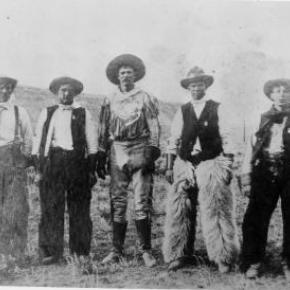
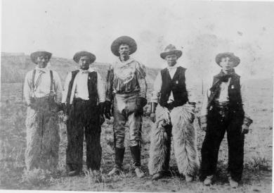
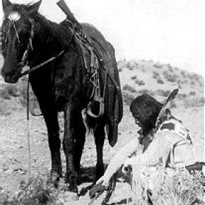
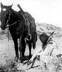
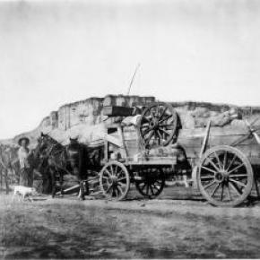
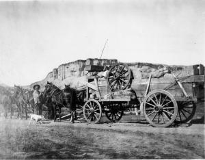
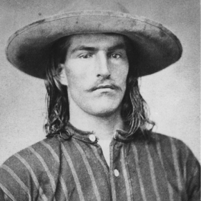
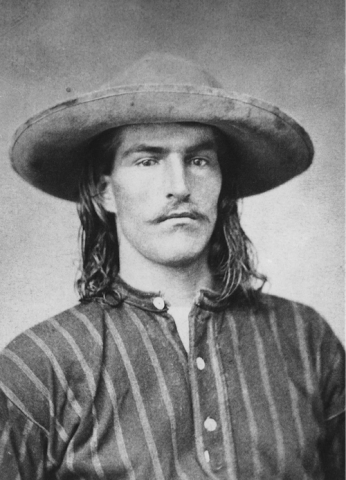
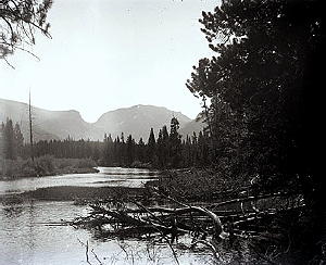
The unrest and hard feelings between the Indians and settlers in Middle Park gave rise to an inevitable conflict the last week of August, 1878. About forty Utes, led by Piah and Washington, started to set up camp in William Cozens’ meadow, near Fraser, taking fence poles to make fires. Cozens drove them off, telling them to replace the poles and leave. The Utes moved down valley about five miles to a spring not far from Junction Ranch (named for the junction of the Rollins Pass and Berthoud Pass wagon roads).

There, Johnson Turner, who leased that land, became increasingly uneasy as the Indians were drinking heavily and expressing anger that Ouray given away their land in treaties with the white man. They wanted Turner to pay them for the hay he was cutting. They tore down his fences for firewood, turned their 100 horses into his meadow, and set up camp. They also laid out a race track on drier ground about a mile way.

Turner complained to the sheriff, Eugene Marker, who rounded up a posse of men, intending to remove the Indians or at least convince them to move on. Accompanying him, on September 1, were Frank Addison, a transient prospector, John Stokes, T.D. Livingston, and Frank Byers.  The posse found only women and children at the camp, since the Ute men were at the race course. Marker, the sheriff, ordered the encampment searched for firearms and when the Ute men returned, an angry confrontation ensued. 

Tabernash and Frank Addison exchanged threats, and Tabernash jumped from his horse and snatched one of the guns piled on the ground. Frank Addison immediately shot him. Tabernash tried to pull his rifle from its scabbard, but that it became entangled, and Addison then fired twice more. Tabernash slumped over the neck of his pony, which ran away through the willows. Apparently Addison recognized Tabernash as the Indian responsible for the killing several of his companions while trapping furs on Grizzly Fork in North Park six years earlier. 

After this bloodshed, the posse persuaded the rest of the Utes to leave, after they buried Tabernash’s body in a shallow grave. No one was ever sure where Tabernash was buried. There was a rumor that the slain Tabernash was buried in a draw not far from Junction Ranch, but when the Grand County Historical Association excavated the site, nothing was found.

A day later, September 3, on a Ranch near Kremmling, Abraham Elliott was shot while cutting wood, and his horses stolen.  In response, the posse moved north in the direction of the White River Reservation. 60 Utes met the posse, and explained that the culprits were Piah and Washington, neither of whom was a part of the White River band.  Ultimately, the Utes signed a council report, returned horses stolen from the Elliott ranch, while the  ranchers returned guns confiscated from the Utes at Junction Ranch.  The matter was considered legally settled, but outrage and fear continued among the settlers and the Utes of the area.

In 1902, E.A. Meredith, chief engineer for the Denver & Salt Lake Railroad, named the town that had grown up with the building of the railroad, after the slain Ute, Tabernash.

The Daily Life of Mountain Men

Washington Irving wrote "There is, perhaps, no class of men on the face of the Earth who lead a life of more continued exertion, peril and excitement, and who are more enamored of their occupations, than the free trappers of the West".

The diet of the mountain men at times consisted of nothing more than meat. When possible. wild plants and berries supplemented needed vitamins.  Pemmican, a meat pounded with fruits and dried in flakes, was convenient to carry and lasted a long time. Mountain men made boudins, sausage made from the intestines of newly killed animals.  These sausages were packed full of undigested grasses which probably protected the mountain men from the illness of scurvy.  The mountain men also chewed on leaves and wild grasses to supplement their vitamin needs.  Potatoes soaked in vinegar supplied further balance to the diet.  Jams and orange marmalade were highly valued whenever they could be obtained. Bread consisted almost entirely of hardtack, a touch cracker usually unsalted, which would not spoil and sturdy enough not to crumble.

Beaver tail soup was considered a delicacy by most mountain men.  Another treat was called "French dumplings", made by mincing buffalo hump with marrow, rolling it into balls, and covering with flour dough and boiled.  Coffee was popular, but limited for transport.  Tea from China came in solid blocks which could be shaved off as needed. 

Normally, mountain men could not carry whiskey on the move but at rendezvous or during visits to forts, they were known as fabulous drinkers.  The most common intoxicant in those days was "Taos Lightening", a strong whiskey manufactured by Simeon Truly of Taos New Mexico.  Various writers have portrayed these men as brutes who lived from one drunken episode to the next, but the facts, and common sense contradict that image.  They could not achieve much in either trapping or trading if they did not stay focused on their outdoor skills and survival. 

Smoking pipes was a luxury, mostly at nights as only a limited amount of tobacco could be obtained.  The mountain men would stretch their tobacco supplies by mixing it with kinnick-kinnick and other plants.

While many traders and trappers dressed in buckskin shirts and trousers, wool garments were even more common and needed to be shrunk to fit.  Probably every mountain man carried what was called a "possibilities bag" that contained personal items such as a pipe, tobacco, soap, needles, and small keepsakes such as mouth-harps.

Before the Sharps "Big 50" rifle was invented, it was necessary to carry a waterproof powder horn and a bag of rifle balls weighing fifty to a pound.  A good knife was essential.  The most sought after of these was the Bowie Knife, invented by Rezin Bowie, but made famous by his brother Jim, who was adept at its use.  Jim was one of the heros killed at the Battle of the Alamo in Texas.

Some mountain men simply loved the lifestyle and had no reason to return to their original homes.  Some had wives back in St. Louis and made an annual trek there every year.  Others had Indian wives or female companions.  Some men claimed to have a wife in every tribe they visited.  Divorce within many tribes was often simple, a matter of putting one's belongings outside the lodge.

As journeys by foot or horse were lonely, mountain men were known to play their mouth harps or sing songs along the trail.  The use of profanity was common, except in the presence of white ladies.  One writer claimed the Indians called white men "Godams" because that swear word was used so frequently by the mountain men, ranch hands and mule skinners.     

The Ish Family
The Ish Family

The prosperous John Lapsley (Laps) Ish family are an example of very successful settlers and entrepreneurs in early Grand County. The Ish family, with eleven children, came by covered wagon to Colorado from Missouri 1863 and settled on a farm outside of Denver.

18-year-old Laps Ish came to Grand County in 1881 to attempt his luck at the short lived mining boom outside of Teller, north of Grand Lake.  He tried his luck at mining for 4 years and also carried the mail between Teller and Grand Lake, on skis or snowshoes in the winter and by foot in the summer. 

Laps Ish married Alice Shearer and homesteaded near Rand (in present day Jackson County). They had two sons, Lesley John Ish and Guy Lapsley Ish. Laps and Alice built the Rand Hotel and operated it until 1910.  The family then moved to Granby and built the Middle Park Auto Company garage and ran a stage line to Grand Lake. They built the Rapids Lodge by operating a sawmill on the Tonahutu River in Grand Lake and opened for business in 1915  They also built the Pine Cone Inn in Grand Lake and Leslie managed it for many years. Laps Ish died in 1943.

The Knight Ranch and Charles Lindbergh

In Grand County during the 1920's, you might have been lucky enough to have taken a plane ride over Grand Lake with Charles Lindbergh.  It may sound preposterous, but Gordon Spitzmiller and his father, Gus, were two of the many fortunate people who got private sightseeing tours over the Grand Lake area with Charles A. Lindbergh as tour guide.

In the early 1920's, the aviation industry was a brand new field open to the adventurers, the thrill seekers and the adventurous.  Charles Lindbergh was one of those men.  In the spring of 1926, Lindbergh had the dream of flying solo over the Atlantic Ocean, from New York to Paris nonstop.  He was a determined man and was resolved to be the first man to cross the Atlantic and win the Orteig Prize.

On May 22, 1919, Raymond Orteig of New York City offered a prize of $25,000 "to be awarded to the first aviator who shall cross the Atlantic in a land or water aircraft (heavier-than-air) from Paris or the shores of France to New York, or from New York to Paris or the shores of France, without stop."

Besides Lindbergh, there were four serious contenders for the Orteig prize, one of which was Commander Richard Byrd, the first man to reach the South Pole.  Lindbergh's courage and enthusiasm for such a flight were not enough; he needed financial backing.  Lindbergh found his financial answer in Harry H. Knight, a young aviator who could usually be found bumming around the Lambert Field in St. Louis.  This was the beginning of the Knight-Lindbergh partnership that would soon change the course of aviation history. 

After being denied any financial assistance by several of St. Louis's businessmen, Lindbergh made an appointment with knight at his brokerage office.  Knight, the president of the St. Louis Air Club, was fascinated with Lindbergh's plan and called his friend, Harold M. Bixby, president of the St. Louis Chamber of Commerce.  Bixby also displayed a strong interest in the obscure stunt flyer and mail pilot.  Together Knight and Bixby formed an organization called "the Spirit of St. Louis", which was dedicated to gathering funds for the flight.  More than $10,000 was needed in order to build a single engine plane and acquire the proper equipment.

Knight went to his father, Harry F. Knight, who was a major power in the realm of finance and an equal partner in the firm Dysart, Gamble & Knight Brokerage Company.  Like his son, the senior Knight was interested in the aviation field and backed every effort to make America conscious of airplane transportation.

Without the financial aid and moral support offered by the Knight family, Charles Lindbergh may not have been able to cross the Atlantic in 1927.  Lindbergh's gratitude to these two men never ebbed.  Lindbergh and, his famous wife Ann Morrow, came often to Grand County as guests of Harry F. Knight whose ranch encompassed 1,500 acres on the South Fork of the Colorado River.  The ranch today is covered by the waters of the Granby Reservoir.

Knight, a nature lover, spent much of his time at this ranch.  It was a haven for sportsmen and adventure seekers, and Lindbergh was a natural for these two categories.  One of the largest and best airstrips in the west was added to the Knight Ranch in order to accommodate the owner and his guests.  Besides the airstrip, the ranch boasted a miniature golf course, a 28 room estate, a private guest "cabin", a good selection of livestock and an array of entertainment that would suit all.  It was a sanctuary for the affluent.

Local people were so enthused about the handsome aviator that they named a 12,000 ft. peak in the Indian Peaks Wilderness Area (east of Granby) "Lindbergh Peak". However, during the 1930's the hero was honored by Adolph Hitler and Lindbergh made a speech favoring Nazism.  This lead to a fall from grace in the eyes of the public.  Even though Lindbergh changed his mind as World War II began, it was too late to regain his former popularity. The peak was renamed "Lone Eagle Peak" which was a nickname for the famous aviator.

After Harry F. Knight died of coronary thrombosis in 1933, his son, along with ranch manager Harry Morris, turned the ranch into a major breeding and beef cattle operation.  It continued as such until 1948, when the Knights were asked to sell it to the federal government or have it condemned to make way for the reservoir.  Moss bought out the cattle operation and most of the buildings were sold, but the colorful memories of the Knight ranch were buried in the depths of Granby Reservoir.

The Norton Family
The Norton Family

From his earliest memories, Mike Norton recalls playing with model ships and submarines with his older brother. His older brother had a ship, and he had the sub. The small pond on the Circle H ranch where he spent his early life before Lake Granby filled up gave little boys' imaginations an ocean. Marbles gave them depth charges. "But I could never find a way to shoot marbles from the sub," Norton laughingly remembers. As the water literally rose above his home, it shaped his life.

The history of Lake Granby and the Norton Marina goes as deep as the water, literally. Grand County's pioneer ranching history lurks at the lake's bottom, sharing its place with rainbow trout amid the vast water supply for eastern Colorado and beyond. Before the lake filled up as part of the Colorado Big Thompson project, ranches like the Lehmans, Knights and Harveys had been stage stops, cattle and dude ranches and even an airstrip used by Charles Lindbergh.

Mike's dad Frank came to Grand County to ranch. "All I ever really wanted to do  first was to be a rancher here," Frank Norton told the Sky-Hi News back in 1997. At fifteen or sixteen years old, Frank Norton in a Model T Roadster traveled from Okmulgee, Oklahoma to Grand County, where he "fell in love" with the ranch that his mother and step-father started around 1930. The Circle H, started by his step-father Jim Harvey in the valley that is now Lake Granby, became his summer home.

By all accounts, Frank Norton loved ranching. The Circle H "was a working ranch and a dude ranch." Harvey's ranch provided a spectacular backdrop highlighted by the Indian Peaks, reaching 13,000 ft high along the Continental Divide. The Circle H offered a caricature map for tourists looking for a real western experience. It led them over Berthoud Pass along hwy 40 to hwy 34 and then right at the Circle H sign to the Ranch. Leaving on horses from the Circle H, Frank Norton and Jim Harvey took them into a vast and remarkable country that, for the most part, can only be reached on foot today.

In those days, the area now protected as the Indian Peaks Wilderness Area faced less threats from overuse. Ranchers hunted the region to supplement the sometimes skinny winter rations. "Jim Harvey shot two elk from his saddle," Mike Norton proudly recalls of his grandfather as we look at a romantic image of Harvey on horseback. Nowadays, quotas limit use through the peak season. The National Park and Forest Service restrict horse traffic and campfires as well. Early Harvey and Norton history highlight a different time and place, when the remote reaches of Indian Peaks could still be reached by trusting a cowboy with a Winchester rifle to get you there and back safely.

For Mike Norton, the water that drowned out his family's ranching history also floated Norton Marina. Going from ranching to the marina business may seem an odd transition, but Mike's family history shows how flexible they were! Frank Norton spent his early youth traveling with his father's tent show, Norton's comedians. "Dad had such funny stories about that," Mike says. When the traveling troupe era ended (talkies and the Great Depression meant "they didn't eat too well sometimes"), Frank Norton moved to Oklahoma with his father before finally joining his mother and Jim Harvey in Grand County.  

Regardless of his occupation, Frank Norton was a showman. Remarkable old photos save the rich history of pack trips into the Indian Peaks area, camp sites on the shores Lake Monarch and rich harvests of rainbow trout. But Frank Norton and his horse Oak rearing high like the lone ranger really show Frank Norton's flare and charisma.

In many ways, Norton Marina continued the Circle H's heritage. Frank's marina included the Gangplank, a restaurant and dancehall that looked like a boat, with porthole windows and originally a rainbow trout aquarium for the bar. His admiral's hat, which Mike still has today, replaced his cowboy hat and a 25 foot Chris Craft named the Bonnie B replaced old Oak as his ride. More or less, this is the world in which Mike Norton grew up.

Growing up Frank's son meant work too. "I was 8 or 10 years old" when we started "Norton's Ark," Mike smiles, referring to the Gangplank restaurant. It was the early fifties in Grand County. "What backhoe?"

No bailouts either! "Those first few years, I nearly starved to death," Frank Norton once told a reporter. "But," he added, "every year the business kept growing and before I knew it we had a good marina going." Before it was over, Norton Marina fulfilled Frank's dream of a family business, only in "boating recreation" instead of ranching!

"It wasn't all roses," Mike agrees. As a boy, Frank Norton went to military school. "They disciplined him and he used the same technique on his kids." Frank expected his kids to help and to obey his commands, without question. Using Tide and a G.I. scrub brush, Mike Norton recalls scrubbing lower units. They painted wooden boats in the wintertime in the shop. The kids came in from school, changed clothes and started working. "Dad and mom had a lot of kids cause they needed a crew!"

Maybe his most memorable job was cleaning out the septic tanks for the cabins that his dad built to help offset the lack of income at a Rocky Mountain marina during winter. After digging up the lids, "dad would put a ladder into the septic tanks." Then, Mike crawled in and shoveled out the waste while his dad hoisted the buckets out. "I was so glad when Ernie Seipps started his septic clean out business," Mike says as we motor along beside Grand Elk Marina's covered docks on a pontoon boat.

The hard work and experience at the marina paid off when Mike joined the military. Like so many of his generation, Mike received his notice to join ground forces in Vietnam. Luckily, about that time, Navy recruiters were in Granby. They showed a strong interest in a National Honors Society student who lived a life on water! The pieces of the puzzle fit, and "that got me in the Navy," says Mike with real appreciation.

In 1973, the family tradition passed on to Mike and his brother Frank when they bought the marina business from their dad. A lifetime of experience came with them. But it took more than dock maintenance, boat service and customer service to run Norton Marina. And, as the brothers took over, the old Admiral Frank Norton stayed in the house he had built next door to the gangplank, insuring that his strong personality was never far away.

Lots of obstacles exist for a marina on public lands. As Mike took over sole ownership from his brother, he also fought to bring the marina under the National Forest Service instead of the National Park Service, which effectively removed the "power of condemnation." "We had to fight for our livelihood," Mike explained when he sold the Marina in January of 1997.

Mother Nature challenged the marina too. Ice might remain on the water for half of May. June snowstorms blow in monster clouds, as awe-inspiring as the calm sunsets. Freezing rain rips into all but the best prepared boaters nearly any time of year, and hailstorms can hit in a heartbeat. "We're like farmers in that way," Mike recalled. "Drought, winters, high water, low water, you can't really help, we understand that."

On the other hand, the glassy waters of Lake Granby reflect the awe-inspiring Indian Peaks along the Continental Divide on calm, sunny days. Tourists and locals try their luck catching the Mackinaw that makes it attractive to sportsmen and women. Intrepid wake boarders mix with sweet sailboats against a beautiful background of rugged peaks that reach high above tree line. On those days, it's hard to think of a more spectacular place.

Through it all, Mike Norton clearly enjoyed his life at Norton Marina. "I liked being out in the elements with the boating public."  He also counts the independence of self-employment and the uniqueness of the marina as blessings in his "good life."

Grand Elk runs the marina today (2009). Its operation rents out slips and moorings, daily pontoon boats and other related services. It's as beautiful as ever to peer across the lake at sunrise in August, and it's as cold and forbidding as ever when the winter winds whip across the thick ice an snow of the lake in January. Few wooden hulls appear during summer season as in the old days, but beautiful boats, both motor and sail, still surround the Marina.

Yes, its original character remains, not far from the surface. The Gangplank changed its name to Mackinaws, where customers in the main room still look out portholes across the lake to the rugged outline of Indian Peaks Wilderness Area, although there is no longer as much space on the dance floor. Those familiar with Indian Peaks recognize old Abe Lincoln lying in his grave along the Continental divide, where Mike's early ranching family led pack trips and today can still be reached, albeit under more controlled circumstances. Today's anchored concrete docks and gas dock continue the process that started with Frank Norton using finger docks that Mike staked in the ground and an old chicken coup from the Circle H to fuel boats.

And in all of Grand Elk Marina's features and history, Frank Norton and his family exist. In the house that they built on site where all of his children were photographed as they grew up and as they graduated from Middle Park High School. In the restaurant where Mike remembers finding the nerve to ask pretty young gals to dance. And, in the numerous family photos that show a smiling, handsome Frank Norton and his attractive family surrounded by high mountains, wooden Chris Craft and a sense of high expectations.

Mike remembers his dad as the "greatest storyteller I've ever known," which he used to his advantage in all occupations. In 2001, I met Frank Norton, only once before he died the next year. He told us about the time Jim Harvey knocked the federal agent who came to tell take their land away to the floor, placed a foot on his chest and said, "If you get up, I'll knock you down again." We could see it happening as he told the story more than 50 years later.

But the story continues beyond Frank Norton. From traveling tents shows to dude ranches to a forty-plus year family run marina, the Nortons made one of Grand County's most enduring "institutions." Entertaining, industrious, and life-loving, Mike simply says, "It's been a really good life." And that's a family tradition.

The Ute Legend of Grand Lake

A group of Utes were camping on the shores of Grand Lake when they were suddenly attacked by an enemy tribe of the Arapaho (and in some versions the Cheyenne as well).  As the brave Ute warriors began fighting, the women and children were hurried onto a large raft for safety and pushed to the middle of the lake.  As the battle continued, a treacherous wind overturned the raft and all the women and children were drowned. Many Ute warriors were also killed during the fighting. 

The legend holds that you can still see ghostly forms in the morning mist rising from the lake and hear the wailing of the lost women and children beneath the winter ice.  The Utes avoided the lake for many years because of these tragic events and evil spirits.

Ute Bill Thompson
Ute Bill Thompson
Ute Bill Thompson, Ute Chief Piah

William Jefferson (Wm./W.J./Bill) Thompson was born on March 26, 1849 in Aurora Township, Preston County, Virginia (1863-West Virginia). The 8th child of 9 children of Wm. & Mary Anne (Wotring) Thompson. His father was a shoemaker at the Wotring Tannery and died in 1853. Mrs. Thompson left Preston County in September 1859 with her children on a covered wagon for Oregon. They arrived at St. Charles, Iowa around Christmas, settling at New Virginia, joining other relatives.

Wm. may have been taken captive by Native Americans prior to entering Colorado Territory. Via ox cart he came to Central City to start mining in 1865. He ventured into adjacent Middle Park, seeking gold in the Troublesome Valley, supplied with 1 ton of flour. He spent four years as a postal carrier from Hot Sulphur Springs to Steamboat Springs, using the Gore Pass route.

Once, the Ute Indians saw him baking biscuits and they enjoyed the “beescuts” until the flour ran out. An altercation left Wm. severely beaten. He made his way to Georgetown and the miners denied him entry, thinking he was a crazy man. One kind miner gave Wm. canvas for clothing, and took him to Idaho Springs. He recovered and was employed as a shoemaker.

Wm. re-entered Middle Park, built a hunting cabin on Muddy Creek ready for the 1867 winter. Chief Yarmonite led 40 Ute men, women and children to Wm’s cabin explaining to him that the Gore Range was covered with snow, and they were in need of food. This time Wm. refused. A rifle match was agreed upon with the loser put to death. Wm. threw his sombrero to the ground as his hair fell to his shoulders. A cry of the Ute went up as they recognized Wm. from the Troublesome. Sub-chief Piah told Wm. they could not fight a Ute brother, and braided Wm’s hair and applied face paint as they were at war with the Arapahoes. A hunt for bison began. Shooting was heard with the thought the Arapahoes arrived. Len Pollard & Sandy Mellon were chasing buffalo, which Wm. shot and killed. Len & Sandy confronted the supposed Ute with Len asking, “Where did you get Bill Thompson’s Winchester rifle?” Wm. played along until Sandy aimed his rifle on Wm. who wisely said, “Don’t over reach yourself, Sandy.” Sandy demanded, “Who in the hell are you!” Bill laughed and told them he was Bill Thompson. The sobriquet of “Ute Bill” was given. Wm. preferred his nick name over his legal name.

Ute Bill carried on as a mountaineer. Hunting and trapping, taking wild game to the Georgetown & Denver markets selling the meat, until laws prohibited the practice. A new career began of driving stagecoaches and freight wagons for the Colorado Stage Company on the Georgetown, Empire & Middle Park Wagon Road, over Berthoud Pass to Grand Lake, Hot Sulphur Springs, Gore Pass, and occasionally Steamboat Springs. One day on Cottonwood Pass, Ute Bill stopped and hiked over a ridge to find 400 Ute tipis on a meadow, imaging this could be a ranch. He homesteaded acreage, bought the home ranch from Al Honscome, and through marriage owned 4000 acres.

The T Lazy S brand was patented. The Thompson Ranch was the 1st in Middle Park allowed to receive water from the Grand (Colorado) River for irrigation. Ute Bill Creek and Ute Bill Ditch 1 & 2 were also patented. Middle Park became Grand County of February 2, 1874. Ute Bill was on the first jury, appointed Road Supervisor, and a delegate to the state Democrat Party Convention. In 1879 he owned Thompson’s Billiard Hall, bought a store from John Kinsey and expanded it into Ute Bill’s Saloon in Hot Sulphur Springs. He also had a game park of tame antelope, deer, and elk.

The “Texas Charley” incident of December 5, 1884 began at the saloon when Texas Charley forced Ute Bill to hand over his prized Winchester rifle. His future father in law played a role in the coroner’s inquest. January 30, 1889 The Middle Park Times listed the sale of the saloon to Billy Pharo with the quote of, “We don’t reach Denver yet but were getting there you see.” An ad in Hot Sulphur Springs complemented the sale.

On December 25, 1893 Ute Bill Tompson was united in marriage to Mabel Smith. The first recorded marriage in the Hot Sulphur Springs Congregational Community Church. Mabel was the eldest daughter of Preston Henry & the late Mary Smith. Ute Bill & Mabel had 6 children Fred Charles, William Preston, John Henry, Otto Woodring, Marion Loman, and Mary Ellen. W.J. Thompson advertised in the Grand County News, January 8, 1904 Sulphur Springs and Kremmling Stage Carries Mail & Express Stage Fare, One Way $1.50 Round Trip, $2.75 In 1903-1904 The Denver, Northwestern & Pacific Railroad (D.N.P.R.R.) was buying ranchers land. Ute Bill refused to sell his for $500 and lost on appeal in District Court receiving $300. However, it was “matter of principal” that he won on, as E.A. Meredith the railroad surveyor diverted the rail bed to be placed on the other side of the Colorado River below the cliffs.

As the excursion trains were passing by the Thompson Ranch on their way to the Railroad Days celebration in Hot Sulphur Springs on September 15, 1905 Ute Bill danced with joy knowing that the “Iron Horse” was NOT allowed to disturb the sacred tipi grounds of the Utes! Ute Bill forgot his grievances and presided over a vast fish fry and barbeque of elk on July 4, 1906. The last cattle trail drive out of Grand County was conducted by 2 aged pioneers, Sam Martin of Muddy Creek, and Ute Bill in 1923. Another matter of principal to avoid paying railroad costs, but of great sentimental value of all the past cattle trail drives. Ute Bill & Mabel both entered St. Luke’s Hospital in Denver for surgery in late February 1926. Ute Bill’s first surgery went well, the second did not. Mabel was not able to be with him as she was recovering from her own.

Many Middle Park pioneers visited them to wish them well. Old friend Charles Nines Sr. who retired in Denver from Pine Ridge Agency, South Dakota a Sioux language interpreter and Trading Post owner was with Ute Bill when he passed away on March 19, 1926, one week shy of his 77th birthday. William Jefferson “Ute Bill” Thompson is buried in the Hot Sulphur Springs Cemetery off of Cottonwood Pass, Looking at Elk Mountain and the original homestead.

This article is dedicated to Lorna Marie Gowen; September 6, 1954-April 14, 2006

Ute Bill Thompson and His Memorial Marker

Dark clouds covered the Continental Divide as we looked east from the ridge leading toward Elk Mountain's remarkable view. Cool winds and spitting snow followed us. We weren't seeking the height of Elk Mountain, but instead, were tracking the historic path of Grand County Pioneer William Jefferson "Ute Bill" Thompson. Specifically, we wanted to locate the memorial marker for Ute Bill that Henry Grafke and Otto Schott placed along this ridge after Ute Bill died in 1926. 

Tracking Thompson requires divergent paths. On one hand, Ute Bill's early presence in Middle Park places him in an era when mountain men and Ute Indians shared the vast herds of elk and deer. Only a handful of hardy souls called Middle Park home when Bill Thompson arrived in the late 1860s or early 70s. On another hand, Thompson settled just east of Hot Sulphur Springs as a young man, where he carved out a cattle ranch that remains in his family today.  

Records prove he owned and operated a billiard hall, drove stagecoaches and established a homestead along the Colorado (then, the Grand) River. But tall tales and oral legends abound too, capturing hair-breath escapes, harrowing western adventures and the mischievous nature of a 19th century westerner. Looking through the numerous historic photos of Ute Bill at the Pioneer Village Museum in Hot Sulphur Springs leaves an impression of a capable trapper, businessman and rancher who textured his image with stories of western adventure. 

With Don Dailey - fellow historic trekker and great grandson of Ute Bill - along, I hoped to pursue the fact and folklore of Ute Bill. As Don pointed out an isolated cabin in the valley below, a Ute Bill tale from the Georgetown Arbitrator of September 1886, "as narrated at the time by one of the participants," captured my imagination.  

Bill Thompson breathed a sigh of relief. The rugged, hungry band of Ute in front of him smiled approvingly as his long black hair fell from his broad-brimmed black hat. A tense moment before, he'd worried about his future as the small band of Ute Indians led by Yarmony came upon his isolated cabin in Middle Park. Fact is, Bill Thompson's hair had just saved his life. Not bein' cut since the Sioux captured him as a child, it hung nearly to his waist.  

Bill was all set up for a Middle Park Winter, with supplies to last through the toughest stretch, when Yarmony and his band came along. Thompson cursed softly at himself for not payin' closer heed to their approach. "Figured they'd be out west by now," Bill muttered as he squared up to his guests. 

Speakin' through a mix of hand signs, broken Ute and English that most fellers in the mountain parks west of the divide understood well enough for basic communication, Bill impressed the band with his manly firmness and calm self-confidence. Then Yarmony spoke, "Beescits," was all he said. Bill hesitated to open his cabin supplies. "Why, them folks are so hungry," he thought to himself, "they're near certain to go mad if they laid eyes on my bacon and flour." At best he'd be without supplies at a risky time of year. "No biscuits, fellers," Bill said with as much certainty as he could muster, "barely enough food fer myself. There's still a shaggy buffalo er two fer the takin' and every feller's got the same chance." When Bill finished talkin' he looked Yarmony square in the eyes. He watched the headman's leathered face swing toward his rough-sawn cabin door thoughtfully. "Beescits," he repeated. 

Yarmony's band, snuggled in their elk skins and trade blankets, looked stoically at Bill. "Well," Bill said, throwing down his last ace, "seems you're intent on havin' my grub and I'm intent you ain't." Then, regrettin' it before he finished sayin' it, Bill raised the stakes, "Why don't we have us a shootin' contest fer it?" No immediate reaction caused Bill to wonder if he'd communicated clearly. Slowly, though, excitement spread through the crowd of Ute, as the entire band - from the pretty young girls to the big-bellies - looked to one feller. In front of Bill stepped a mountain-sized-Ute feller, creating a shadow as he approached. "Piah," the Ute whispered, breaking into a quiet chaos of conversations. Movin' quick and hopin' for some break, Bill scooped up his improved Winchester rifle as he threw off his broad-brimmed black hat so nothin' could obstruct his shootin' eye. Just as soon as his long black hair fell near his waist, the tense moment ended with a gasp from the Ute, followed by a welcome reception that meant more to Bill than any he recollected! Bill determined then and thar on never cuttin' his hair again! 

As he eased down the gun smilin', all them pretty Ute girls began paintin' his face and braidin' his locks. Bill was feelin' positively giddy about his good fortune. Decidin' he just might owe these hungry Utes a favor fer endin' a potentially tragic shootin', he led 'em to a nearby ravine where he'd been watchin' a small herd of shaggy buffalo. Now Bill Thompson figured he'd repay 'em with meat, and still keep his own supplies. Leavin' the Ute on a rise above the ravine, he sauntered down to the fresh buffalo trail just as he heard the thunder of hooves around the ravine's bend to the south. Settlin' into a remote stand of lodge pole pines, he sat right along the path of the rumblin' bison. Pickin' out his choices as they rounded the bend, Bill's Winchester boomed repeatedly, each shot bringin' down a fat cow or a young bull.          

Swaggering toward his kills, Bill was suddenly confronted by Sandy Mellon and Len Pollard, sneakin' along that ravine behind the buffalo. Not recognizin' Bill through all the paint and braids, Sandy thundered to Len that this Ute feller must "a stole Bill Thompon's gun," because there weren't many repeaters like his. Both their guns were trained on Bill.   Calmly, Bill broke the silence. "Don't over-reach yourself, Sandy." Yes sir, Sandy knew from the voice that this-here Ute feller in front of him was really Bill Thompson. That day, he became Ute Bill.  

Breathing hard to make the final incline, Don and I reached the point along the ridge of Elk Mountain where we expected to find the memorial. There it was, as we had hoped. After a hurrah for our success, we slowly read the plaque: "Hunting Grounds of "Ute Bill.'" As we snapped photos and drank water from our packs, I decided that where historic fact and local folklore meet, an authentic western tale begins.

Ute Legend of Canyons

Major John Wesley Powell was in the first party to make a recorded climb of Pikes Peak in 1868.  Later, he would lead the first expedition of the Green and Colorado (Grand) Rivers. He was very interested in the Indian tribes that he encountered and later became head of the new U.S. Bureau of Ethnology.  He recorded this legend as told by the Utes on his first visit to the Colorado mountains, during his Pikes Peak climb.

A chief of the Utes mourned the death of his beloved wife, and his grief was so deep, that no one could console him.  Then the Great Spirit, Ta-Vwoats, appeared to him and promised to take him southwest to where he could see where his wife had gone, if he would promise to grieve no more.

Ta-Vwoats rolled a magical ball before him and it crushed mountains, earth and rocks, making a trail to the land of the afterlife.  Following the ball was a rolling globe of fire which the Great Spirit and the chief followed.  At last they were in the happy land where all was blessed with plenty and joy.  This was where the chief's wife had gone and he was glad to see it.

When they returned, Ta-Vwoats told the chief that he must never travel that trail again during life and warned all the people against it.  Knowing that those who had lost their loved ones would be tempted to make the journey, Ta-Vwoats rolled a river into the canyons so that no one could enter.

Ute Legend of the Quaking Aspen

It is amazing to behold the continuous quivering of aspen leaves in groves around Grand County, even when there is no apparent breeze.

According to Ute legend, the reason for this unique aspect of the aspen tree happened during a visit to Erath from the Great Spirit during a special full moon.  All of nature anticipated the Spirit's arrival and trembled to pay homage.  All except the proud and beautiful aspen. The aspens stood still, refusing to pay proper respect. The Great Spirit was furious and decreed that, from that time on, the aspen leaves would tremble whenever anyone looked upon them.

Articles to Browse

Topic: Biographies

Betty Cranmer

November 2007


Betty Cranmer, a longtime Granby resident, says she doesn't like to be in the spotlight. Her modest home with brown siding and roof, tucked into a hill behind a stately spruce tree, reflects nothing of her and her family's past.  Betty's story - full of heartache and triumph - deserves recognition.

She is a World War II veteran, a cancer-survivor, and the mother of five children (her sixth son, Forrest, died when he was 33.) She is the wife of the late Chappell Cranmer, whose father, George Cranmer, is the Cranmer the ski run at Winter Park Resort is named after.  At 86 years old, Betty has lived a fuller life than many - and she shows no signs of slowing down.

She was born in England on Aug. 29, 1921. When she was 18, she joined the Women's Royal Air Force and was stationed at a burn and plastic surgery hospital, later named Queen Victoria Cottage Hospital. Deep down, she had wanted to be stationed at a fighter station instead - closer to "where the action was" - because she had just lost her first love, an Australian man, who was shot down by enemy fire.  "My job was to clean up burns, which were very bad," Betty said. "A lot of them didn't have eyelids, or their noses were burned off."

Betty was fascinated by the way the doctors would build up the soldier's faces by skin grafting, she said.  "It was very interesting, once you get over the smell of burns, and get into the feeling you're doing a service for those people," she said. Betty served at the hospital for four-and-a-half years. Her home was in a small town in Sussex, 30 miles from the south coast of England. The town was sometimes known as "bomb alley" during the war. Because of the town's proximity to London, German planes would often drop their bombs on her town on their way to London, she said.

She recalled pilotless planes - "big bombs with wings, nothing else" - and running for cover, although there wasn't any. She recalled the Battle of Britain, and how the sky was "almost black" with hundreds of German planes. One night, as she was working at the hospital, a young pilot from Denver was brought in. He was a member of the Canadian Air Force who had crashed in the North Sea, and spent 14 days on a dingey with no food or water. When he was finally found, semi-conscious, he was brought to a nearby hospital. "When they took his boots off, his toes came off, because they'd been immersed in water and cold for so long," Betty said. "So they sent him down to our hospital to see if we could do some grafting on his feet."

After a year of treatment, however, there was nothing the hospital could do for the young pilot; to save his life, they amputated his legs, and he was forced to use a wheelchair.  He and Betty struck up a friendship, and she would often take him to town where they'd visit the cinema or local pub. Eventually, they fell in love.

One day after leaving the cinema early because Betty had to return to work, they were heading down a hill toward the hospital when a German plane flew over them. Both of them were in uniform.  "I said, "My goodnesss!? There were no sirens, nothing ."  The plane circled and opened fire.    "I was so frightened, I let go of his (wheel)chair. Thankfully he grabbed the front wheels and was able to stop himself."

Betty and the young man returned to the hospital safely, but the attack had brought in many casualties. Eighty people were killed and 250 were wounded. The cinema they attended was destroyed by a single bomb. Betty's eyes glaze over as she remembers how lucky they had been to survive that day.  "I wasn't a believer ... I didn't know there was a God in those days, because when you're in a war, well ... But I think then, by the grace of God, we got out of that."   Betty and the pilot were married in the mid-1940s, and had a daughter named Susan after the war ended. Although the war was over, life wasn't any easier, Betty said.  "It's hard for people who were in the war in
England to describe rationing to people in this country. ... We had two ounces of meat per week, per person. You could not buy anything in the shops at all without giving up coupons. Two ounces of butter, four ounces of sugar."

Betty was pregnant with her second child when her husband died suddenly due to complications. Before his death, he told her to move to Denver where his father lived. It was 1946, and America offered a better life. Betty took Susan and all that they had and moved to Denver; she first set foot on American soil in May 1946, where she eventually had her second child, Holbrook.
Two years later, she met Chappell Cranmer, who was an investor at the time. They were married and had four children: Allen, Bruce, Genie and Forrest, and lived in Denver for 25 years. In 1969, her husband decided to move to Granby.  "He attended seminary school and was ordained as a priest," Betty explained. "The Bishop said, I want you to move to Granby.' "Betty joined her husband one year later, and they bought a home she would continue to live in the next 37 years.


Chappell, or "Chap," started a church in 1981 called St. Columba Chapel - later named Cranmer Chapel - that is located behind the Silver Screen Cinema in downtown Winter Park. It is there to this day and is a vital part of the local community. Betty and her husband continued to visit England every two years to see her parents, but in 1994 she was diagnosed with cancer in her abdomen. Betty beat the cancer - despite a doctor's prognosis that she had three weeks to live - and would go on to fight and survive two more major bouts of cancer.

Chap died in 2000, two years after Betty fought off colon cancer. She continues to travel, and has just returned from a trip to England and Spain with her son.  As she sits in her couch chair, her white and gray hair framed by the sun peeking through her window, one can't help but be in awe of Betty Cramner. Her home is immaculate but cozy and inviting, and the rooms are filled with photographs of children and grandchildren. She loves living in Granby, she said, where everything is close by.
"I'm very independent. I don't like driving in big blizzards and stuff like that, so I can walk to the library, the post office, the church every Sunday. ... So I like living here. I couldn't live in a big city anymore."

Betty knows she has led an amazing life, but her humbleness is what makes her unique. As she rattles off her daily routine - snowshoeing, walking, swimming, attending four different Bible studies - she mentions she is a volunteer at Cold Springs, a local greenhouse just up the road. "I love flowers," she said, as she turns and faces her bay window full of geraniums and different types of plants. "Would you like one? I have plenty."

Topic: Biographies
Winter Park Ski Shop, Joyce and George Engel

George & Joyce Engel

Winter Park Ski Shop, Joyce and George Engel

Here is the story of how Joyce and George Engel became legends in Winter Park and Fraser. In 1945, Winter Park Resort hired George Engel as their very first paid ski patroller.  Little could George have known that this job would lead him to his wife, Joyce Hanna, disembarking from a ski train, and together they would call Winter Park and the Fraser Valley their home for life. Along with Joyce and their daughters, the Engel Family would have a lasting influence not only on Winter Park Resort but on the Fraser Valley community as well.

In the year following his hiring as Winter Park’s ski patroller, George Engel took on different responsibilities at the ski area, such as plowing the parking lot and collecting rental fees in the bunkhouse.  Gordy Wren and Frank Bulkley formed Colorado Outings in 1946 and started the ski school at Winter Park.  As director of the ski school, Gordy Wren hired George Engel as a ski instructor. That same year George passed one of the first ski instructor certification exams ever held.  By 1949, the Professional Ski Instructors of America was formed and Engel held pin # 12.

Gordy Wren was busy practicing for the 1948 Olympics and consequently sold his share in Colorado Outings.  This gave George Engel the opportunity to buy into the company and he became director and eventually sole owner of the ski school. George added the Winter Park Ski Shop onto the ski school.  

George met the love of his life, Joyce Hanna in 1951 as she disembarked from the Winter Park Ski Train.  Joyce, with two BA degrees from the University of Colorado, was ready to ski and work.  After dating for three weeks, George proposed to his future bride and business partner. The Winter Park Ski School under George’s leadership, and the Winter Park Ski Shop with Joyce at the helm, became fixtures of the ski area. George and Joyce’s two daughters grew up on the slopes.

Daughters Wendy and Janet tell wonderful stories from when the family lived in an apartment above the Winter Park Ski Shop.  After Winter Park Resort bought the ski school in 1982, they demolished the shop and apartment to make way for the West Portal Station.

Along with skiing, another Engel passion was horses which led to their acquiring 40 acres along County Road 5 where they built Casa de Engel.  From their ranch, the Engels helped to establish the Winter Park Horseman’s Association and the High Country Stampede Rodeo at John Work Arena in Fraser.    Naturally, Janet Engel became a rodeo star. The Engels were also involved with the Middle Park Fair and Rodeo for decades.

As community leaders, the Engels transformed Winter Park Resort and the Fraser Valley. They helped start the Fraser Valley Metropolitan Recreation District, the Winter Park Chamber of Commerce and the Winter Park Sanitation District.  Joyce Engel was a founder of the Grand County Concert Series bringing live classical music to this rural community.  In 1968, George Engel was instrumental in bringing the National Sports Center for the Disabled to Winter Park. The family’s wide-ranging passions enrich all our lives then, now and into the future.   


Topic: Mountains

Rollins or Corona - What shall it be called?

Travel across various passes of the Continental Divide occurred long before white men showed up. Indeed, as anthropologist James Benedict wrote c. 1975, some 10,000 years ago, prehistoric Indians camped, hunted, and built hunting walls on the upper reaches of Rollins Pass, as well as moving in and out of Middle Park for the warm summer months.

Historic Indians followed the same paths. In the earliest days of non-Indian access, a particular pass at the head of Boulder Creek was dubbed Boulder Pass. Capt. Jacob Bonesteel, including wagons, made the first recorded crossing by a white man at this point in April 1862. Three years later, a group of Mormons brought wagons over this route and a year later, promoters of new roads into Middle Park brought in many wagons and livestock.

In fact, tourists were starting to enter the park by a number of routes, and one of them, Samuel Bowles, who wrote a fascinating account of his trip, including his return to Denver via Boulder Pass. Interest was growing rapidly for a road over the Divide, into Hot Sulphur Springs, and on into Utah. One promoter, John Quincy Adams Rollins, from New Hampshire, teamed up with William N. Byers and Porter M. Smart to carry this project through. Rollins was interested in crossing the Divide; Byers was promoting the Springs; Porter wanted to develop the valley of the Middle Yampa. All three were pushing to have Middle Park officially named as Grand County, a challenge finally accomplished in 1874. So Rollins and associates started his road, reaching the top in 1873.

That next winter, they publicized this access and in June, Jimmy Crawford brought his family and wagons to Rollinsville and thence to Yankee Doodle Lake, ready to cross the pass now named Rollins Pass by the developer. But the road ended, and they found Rollins' men still hacking the road out of the granite! Jimmy and his crew found it necessary to leave their wagons and help. Finally, on June 10th, the family was able to head for the top. Jimmy borrowed two yokes of oxen, hitching them to mules, and then to his horse. The road was so rough that the procession could proceed but a few feet before having to rest. The family itself climbed on foot. At the summit, they discovered only a rough swath cut down through the trees on the western side. The "road" dropped down between the lakes and followed Ranch Creek to its junction with the Fraser River.

Rollins quickly realized that Berthoud Pass, which also opened in 1874, was superior to his own pass for wheeled vehicles, so he determined to hedge his bets. He initiated the first mail service into the county in 1873. He also built a commodious hotel where his road joined the Berthoud Pass road at the confluence of Crooked Creek and the Fraser. He called it the Junction House. Next, he proposed to the builders of Berthoud Pass that they form a joint ownership of the two roads between Junction Ranch and the Springs. Tickets would be issued for both routes and revenues would be shared. The two companies would build a bridge over the Grand at Hot Sulphur Springs. He even buttered up his rivals by complementing their work. All this was accomplished, although the mail route soon moved to Berthoud Pass, because of the severe winters on Rollins Pass.

The bridge was started in November 1874. From the beginning, Rollins' road was preferred for trailing livestock, because there were fewer problems with heavy timber and bogs. For years, the Church brothers, George and John, who introduced the Hereford breed into the county, trailed their cattle for summering in what became known as Church Park. However, tourists such as Irving Hale still drove wagons over Rollins Pass in 1878. About 1880, interest burgeoned for bringing a railroad up South Boulder Canyon and through a tunnel near Rollins Pass. Numerous surveys were completed all along the area. David Moffat settled on Rollins Pass for the tunnel site but decided first to put a temporary line over the top.

Thus, in the summer of 1903, a formal contract was let for work up and over the Pass itself. By 1904, the workers reached Arrowhead and they also built a work station on top, called Corona Station, or "crown of the mountain." This railroad construction town of Corona, located at over 11,600 feet at the top of Rollins Pass (first called Boulder Pass) along the Continental Divide was the highest railroad station in the world. It became obvious by 1905 that the Corona area would require snowsheds if trains were to travel, even irregularly, during the winter. Still, word got out of the spectacular splendor of Rollins Pass and tourists flocked in on summer train excursions, sometimes stopping on top, sometimes going as far as Arrow.

In 1913, a fine hotel was built next to the rail facilities. Because Rollins Pass was right in the middle of severe weather patterns, a weather station was built on top, as well as one down at Sunnyside. In 1915, Rollins Pass was actually proposed to be the south boundary of a proposed "Estes National Park." Later, on the National Historic Register, the district was listed in 1997 as the Denver, Northwestern and Pacific Railway Historic District--Rollinsville & Middle Park Wagon Road. It was also identified as the Rollinsville and Middle Park Wagon Road; Boulder Wagon Road, Rollins Pass, and Rollinsville area. In 1956, Governor Steve McNichols had presided at the official re-opening of the four percent grade to vehicle traffic over Corona Pass, expressing the hope that the route would someday be paved. The Colorado Game and Fish Department and the U.S. Forest Service made additional improvements, and the Arapaho and Roosevelt National Forests put out a 24-page booklet titled "The Moffat Road: A Self-Guiding Auto Tour."

The road crossed two of the original railroad trestles near Corona but those trestles, even if reached by 4-wheel vehicles, were crumbling and could no longer even be crossed safely on foot. The current self-guided auto tour refers to Rollins Pass, as well as the Moffat Road and the Boulder Wagon Road. Corona Station and Hotel are discussed. In 1979, a portion of the auto road over Corona Pass was permanently closed because of a cave-in of the "Needle's Eye," a tunnel located before the trestles heading west from the Moffat Tunnel's East Portal. The tunnel reopened on July 3, 1988, thanks to efforts of the Rollins Pass Restoration Association on both sides of the Divide, with the cooperation of the U.S. Forest Service, Colorado History Society, and Boulder, Grand, and Gilpin Counties. It then closed once more when another rockfall hit the tunnel on July 15, 1990. The RPRA is continuing its efforts for re-opening. The noted photographer, Charles McClure, took many outstanding photos of the Rollins Pass road.

One, titled "Group on Rollins Pass, shows well-dressed men and women stand on a snowfield making snowballs on Rollins Pass, Moffat Road, Boulder or Grand County, Colorado; probably on Denver, Northwestern and Pacific excursion train. Date: between 1904 and 1913 near Corona Station." Another photo shows a "30 ft. snowcut on Rollins Pass, Moffat Road photo. Denver and Salt Lake Arrow passenger car is parked east of Corona snowshed by the thirty foot snowbank cut, Rollins Pass, Colorado; it shows men, women and railroad employees posed behind train, on the roof and on the snowbank and a standard gauge track. Date: between 1904 and 1915." A sign at the highway turn onto the Moffat roadbed says: The Moffat Road "Hill Route" Also called "Corona Pass Road", this road over the Continental Divide was the original "Hill Route" of the Denver, Northwestern & Pacific Railway built by David H. Moffat in 1903. It crosses Rollins Pass at 11,666 feet elevation. On top of Rollins Pass, a sign says: Elevation 11, 660 feet, John Quincy Adams Rollins established a toll wagon road through this pass in the mid 1870's. David H. Moffat's Denver, Northwestern & Pacific Railway crossed the Continental Divide at this point in 1903.

First known as Boulder Pass, then Rollins Pass, the railroad workers dubbed it "Corona", the crown of the "Top of the world." A railroad station, hotel, restaurant and workers' quarters existed here until 1928 when the railroad was abandoned due to the building of the Moffat Tunnel. Identifications in various trail and geographical guides say: Rollins Pass (el. 11,680 ft) is a high mountain pass in the Rocky Mountains of north-central Colorado in the United States. The pass is located on the continental divide at the crest of the Front Range southwest of Boulder, at the boundary of Grand County, Colorado and Boulder County, Colorado. Rollins Pass (a.k.a. Corona Pass) sits approximately 5 miles east and above the popular ski areas around Winter Park, between Winter Park and Rollinsville. The pass is traversed by an unpaved road, mostly the former roadbed of the Denver and Salt Lake Railway which abandoned the route in 1928 when the Moffat Tunnel opened to replace it. Railroad advertising called this the "Top O' the World" and it referred to the Moffat Route over the continental divide and the Rocky Mountains. Rollins Pass was the primary travel route west from Denver until an easier road over Berthoud Pass was constructed. The Denver, Northwestern and Pacific railroad laid its tracks across the pass in 1903-1904 and established a Depot at Corona on the crest. It can be noted that in R.C. Black's Island in the Rockies, the term "Corona Pass" was mentioned one time, on p. 351; the terms "Corona Station" or "Corona Snowsheds were used. In Dismantling the Rails That Climbed, Rollins Pass was used, the Corona hotel, and just once, Corona Pass; 1936.

In Maggie By My Side, it was Boulder Pass and Rollins Pass. In Rails that Climbed, Rollins Pass, the Corona shed, weather at Corona, Rollins Pass Snow Shed, other references to Corona as a site. In Guide to the Colorado Mountains (Orme) , they speak of the Corona Trail to Rollins Pass. High Country Names (Ward) used Rollins Pass entirely. Only Hiking Grand County, Colorado, published 2002 by Carr speaks of Corona Pass, with reference to Rollins Pass (near the town of Corona), Moffat Road. The term "town" might be questionable; there was only a small restaurant, workers quarters, railroad offices, and in 1913, the hotel. Current maps, USFS and the Grand County Trail Map, show Rollins Pass, with Corona at the side as being a site. The use of "Corona Pass' seems to be a rather recent innovation that has come into being with tourism efforts in the upper Fraser Valley. Rollins Pass From Island in the Rockies p. 45 Rollins Pass was originally known as Boulder Pass, first recorded being crossed by whites, by Capt. Jacob Bonesteel in April 1862. Their supplies were carried in wagons. A second organized party went over the same pass in 1865. In 1866, promoters of access into Grand County brought many wagons and livestock over Boulder Pass.In 1867, Samuel Bowles and a group returned home to Denver via Boulder Pass. In 1873-74, two roads were proposed into the county, one of Berthouds pass and one over Boulder Pass. This was the same time that the county was named "Grand". J..A Rollins and his associates started the road and reached the top of the pass in 1873, at which time they envisaged a road from HSS into Utah. The first wagons went over in June 1874. The western descent was so bad that it never was much patronized by wheeled vehicles, instead becoming primarily used for trailing of cattle. At this time the name Boulder Pass disappeared from maps and Rollins Pass became the official name. p. 85. p. 80 Lots of schemes to build roads into GC, but of all the schemes for transport, only one, the Rollinsville and Middle Park Wagon Road showed any promise. T

hat was designed by John Quincy Adams Rollins, from NH, a gifted promoter, a son of a clergyman, second of 19 children. He was a farmer, miner, freighter, road bulder, and platter of towns. He was perhaps the most accomplished billiard player west of the Mississippi. He was a Colorado resident at least by 1866. His finances were up and down, but he was tremendously strong. In December 1884, when he was 68, he thought nothing of a 3-day snow-clogged crossing of the Continental Divide. p. 85 Rollins was interested in MP as an investor and he was interested in extending his road into Utah.. At the same time, a Porter M. Smart was likewise excited about speculating in frontier projects and was working at developing the valley of the Middle Yampa. William N. Byers was busy planning for HSS. These three men launched at least two petitions, with more than 80 "residents" for creating GC. Grand County was created that year, 1874. p. 89 With the creation of GC, people began to consider the area more seriously. p. 92 There was no official mail into the county until 1873 when Rollins brought in the first US pouch over his pass. In May 1874, he built a commodious hotel at the confluence of Crooked Creek and the Fraser, known as the Junction House. p. 94 Rollins knew that the road over Berthoud Pass was superior to Rollins Pass; his main advantage was the railhead at Blackhawk.

So Rollins proposed a joint ownership and operation of the two roads for the line between Junction Ranch and HSS. Tickets would be issued for both routes and revenues would be shared. The two companies would build a bridge across the Grand at HSS. Rollins even complimented the Berthoud work. This merger was completed soon. p. 104 This bridge was started in November 1874. p. 108 A mail contract was made in July 1875 for once a week delivery over Rollins Pass, but conditions were so severe that the route was changed to Berthoud Pass. p. 110 From the beginning, Rollins Pass was used in preference to Berthoud Pass for trailing livestock, because there were fewer problems with timber and bogs. However, late spring snowdrifts were a problem, so 20-30 horses were often brought along to break trail. The Church brothers, ?George and John, summered their cattle in what became known as Church Park and dug the Church Ditch. They also introduced the celebrated Hereford breed into GC. p. 170-171 As interest in bringing a railroad into and through GC developed, about 1880, various stockholders proposed to build up South Boulder Canyon to Yankee Doodle Lake and start a tunnel near Rollins Pass. Nothing came of the first attempts but by the end of July 1881, numerous surveys had been made for that tunnel. p. 238 Cattle was still being trailed out via Rollins Pass up to the turn of the century. p. 258 David Moffat and Horace Sumner, his chief engineer, in the fall of 1903, were planning the tunnel for future excavation; but in the meantime a temporary line was planned for crissing Rollins Pass, at 11,640 feet. p. 264 A formal contract was let for the work over Rollins Pass in August 1903. The loftiest sections were started first, and the first cuts at the top were nearly finished by the 26th of October and tunneling started at Riflesight Notch. As snow came, work slowed to a standstill. p. 265 Work in 1904 was extremely slow until the end of August.

An encampment was built at Arrowhead and a station at the crest of the Divide was named Corona Station, where long snow sheds were built almost immediately. p. 267 Arrowhead was soon shortened to Arrow, when a post office was opened there in 1905. Travel on the grades, at 4-5% grades up over Rollins Pass was exceedingly difficult. p. 270 In 1908, word of the scenic splendor of Rollins Pass was becoming known world wide. Also, Rollins Pass and its "Corona station" were attracting the attention fo the US Weather Bureau, for the pass lay squarely in the center of the region of heaviest snowfall on the entire Colorado Continental Divide. p. 344 A terrible winter in 1909 made people think that Rollins Pass was never going to be practical for the long term. Time and again freight and passengers were stuck on top at the Corona facility. In 1913, a $10,000 hotel was built at Corona next to the rail facilities. From Dismantling the Rails That Climbed p. 6 The railroad went from Denver to the top of Rollins Pass. p. 8 Snowsheds were built over the tracks at Corona and other strategic places in 1905. p. 12 The top was referred to as "Corona Pass" 1936. p. 16 Crews who were to removed tails and ties reached Corona at the top of Rollins Pass 1936. p. 20 Reference to the Corona hotel From Maggie By My Side p. 1 Jimmy Crawford heard that a man named John Quincy Adams Rollins was building a road over the range at a place called Boulder Pass. 1873 p. 9-14 June 1874 The Crawford family traveled to Rollinsville and then to Yankee Doodle Lake, where the road ended. Rollins' men were still hacking the road out of the granite. Jimmy and his crew helped. On the morning of June 10, the family started out to go over the rocks and up the mountain. Then he borrowed two yokes of oxen to his wagon, then mules, then his horse. The animals had to rest every few feet; the family climbed on foot. There was no shelter at the top. Rollins' men had done no work yet on the west side of the pass except to cut a rough swath down through the trees. The road dropped down along Ranch Creek. From Rails That Climb published 1950 p. 43 Leyden Junction to Tolland to Rollins Pass. P. 63-64 Many references to Tunnels as identifiers of location. p. 76-77, 78 reference to the old Rollins Pass toll road; first mention of the place called Corona- crown of the mountain. Most references are to Rollins Pass. The Corona shed is mentioned, p. 82. p. 83 Sunnyside water stop, Loop Trestle and Tunnel, Ranch Creek Trestle and water stop, Arrow. p. 95, 100- 101 It is eleven miles from Arrowhead to Rollins Pass. Rollins Pass-Boulder wagon road; other references p. 107 - 112 reference to Corona shed. Reference to pipe line to Corona; a number of comments to Rollins Pass p. 119 weather at Corona p. 120-121 Rollins Pass p. 151 Rollins Pass p. 182 photo of "Rollins Pass Snow Shed" "This Corona station burned one night." p. 188 photo of June at Rollins Pass p. 192-194 photos of Corona shed and other buildings; Rollins Pass p. 252 walking on top of snow shed at Corona p. 271- 272. 1910 Snowshed at Corona p. 312-314 Rollins Pass; Rollins Pass snowshed; Corona; Corona siding p. 324 Corona; Sunnyside weather report station p. 326 Corona sheds p. 333-335 Corona shed; references to "Corona" as a place From Guide to the Colorado Mountains published 1974 p. 54-55 Corona Trail, going from East Portal to Rollins Pass From High Country Names published 1972 p. 105 Irving Hale in 1878 drove his wagon over Rollins Pass, now nearly abandoned as a wagon road. p. 131 David Moffat decides to build a temporary line over Rollins Pass. p. 165 In 1915, Rollins Pass was proposed to be the south boundary of a proposed "Estes National Park". From Hiking Grand County, Colorado published 2002 p. 52 Trailhead on the "Moffat Road to Corona Pass". In same paragraph, it becomes Rollins Pass (near the town of Corona). On p. 54, reference to the Corona Road. On p. 57, map shows Rollins Pass with Corona marked as a "site." p. 56, reference to the old railroad bed used crossing the Divide at Rollins Pass, near the town of Corona.

Sometimes called Corona Pass. p. 60-61 Rollins Pass Wagon Road historical notes on JQA Rollins and how to find his wagon road over Rollins Pass, following Ranch Creek to Tabernash. p. 66 Rollins Pass (Corona) to Devil's Thumb From GCHA Journal The Journey p. 6 Rollins Pass used by Indians; comment in 1981 From GCHA Journal Middle Park Indians to 1881 p. 8 Archaic hunters camped in the Rollins Pass area; written mid-1970's The current maps, USFS and Grand County Trail Map, show Rollins Pass with Corona at the side as being a site. The Rollins Pass Restoration Association for many years, and currently, has been trying to open the road and Needles Eye Tunnel. The self-guided auto tour refers to Rollins Pass, as well as the Moffat Road and the Boulder Wagon Road. Corona Station and Hotel are discussed. On the National Historic Register Denver, Northwestern and Pacific Railway Historic District--Rollinsville & Middle Park Wagon Road (Boundary Increase) ** (added 1997 - District - #97001114) Also known as Rollinsville and Middle Park Wagon Road;Boulder Wagon Road;R Rollins Pass, Rollinsville Corona Station and Hotel The railroad construction town of Corona, Colorado, located at over 11,600 feet at the top Corona Pass (first called Boulder Pass) along the Continental Divide was the highest railroad station in the world. It was situated on an old Native American trail, the same trail it is believed the Mormons traveled on their way to Utah. The road was improved by the U.S. Army, then further improved in 1866 by General John Q. Rollins, for whom the pass and the town of Rollinsville were officially named. Because of the high drifts of snow, the pass was only open from around July to the first big snowstorm two or three months later. In 1956, Governor Steve McNichols presided at the official re-opening of the four percent grade to vehicle traffic over Corona Pass, expressing the hope that the route would someday be paved. The Colorado Game and Fish Department and the U.S. Forest Service made additional improvements, and the Arapaho and Roosevelt National Forests put out a 24-page booklet titled "The Moffat Road: A Self-Guiding Auto Tour."

The road crossed two of the original railroad trestles near Corona but those trestles, even if reached by 4-wheel vehicles, are crumbling and can no longer even be crossed safely on foot. In 1979, a portion of the auto road over Corona Pass was permanently closed because of a cave-in of the "Needle's Eye," a tunnel that came before the trestles on a westward drive from the Moffat Tunnel's East Portal area. The tunnel reopened on July 3, 1988, thanks to the efforts of the Rollins Pass Restoration Association with the cooperation of the U.S. Forest Service, Colorado History Society, and Boulder, Grand, and Gilpin Counties. It was then closed once more when another rockfall hit the tunnel on July 15, 1990. John K. Aldrich is a geologist, lecturer, and author whose "Ghosts of . . . " books and accompanying topo maps are a boon to hobbyists, explorers, and those interested in Colorado mining history. Date: 02/04/08 05:13 Rollins Pass Milepost 16 Corona Station. Picture 6 below, is DPL photo X-7388. "Title: Corona, Colorado, interior of snowshed. Summary: Passengers stand next to the covered train depot at Rollins Pass, in Corona (Grand County), Colorado. The tracks of the Denver, Northwestern & Pacific Railway are in the foreground. The depot is constructed of logs, and the roof of the snowshed is upheld by timbers. Sunlight streams through the opening at the end of the snowshed. Date: (between 1904 and 1913). Source: E. T. Bollinger from W. I. Hoklas." Picture 7 below, is DPL photo MCC-454A. "Title: Group on Rollins Pass. Summary: Well dressed men and women stand on a snowfield making snowballs, Rollins Pass, Moffat Road, Boulder or Grand County, Colorado; probably on Denver, Northwestern and Pacific excursion train. Date: (between 1904 and 1913). Creator: Louis Charles McClure 1867-1957. Picture 8 below, is DPL photo MCC-624. "Title: 30 ft. snowcut, Rollins Pass, Moffat Road photo. Summary: Denver and Salt Lake Arrow Turn (passenger car) parked east of Corona snowshed by thirty foot snowbank cut, Rollins Pass, Colorado; shows men, women and railroad employees posed behind train, on roof and on snowbank and standard gauge track. Date: (between 1904 and 1915 The highway sign says The Moffat Road "Hill Route" Also called "Corona Pass Road", this road over the Continental Divide was the original "Hill Route" of the Denver, Northwestern & Pacific Railway built by David H. Moffat in 1903. It crosses Rollins Pass at 11,666 feet elevation. On top of Rollins Pass, a sign says: Rollins Pass Elevation 11, 660 feet John Quincy Adams Rollins established a toll wagon road through this pass in the mid 1860-s. David H. Moffat's Denver, Northwestern & Pacific Railway crossed the Continental Divide at this point in 1903. First known as Boulder Pass, then Rollins Pass, the railroad workers dubbed it "Corona", the crown of the "Top of the world." A railroad station, hotel, restaurant and workers' quarters existed here until 1928 when the railroad was abandoned due to the building of the Moffat Tunnel. Rollins Pass Elevation 11,680 ft (3,560.1 m) Traversed by Unpaved road Location Boulder_County,_Colorado / Grand,Colorado Rollins Pass (el. 11,680 ft) is a high mountain pass in the Rocky Mountains of north-central Colorado in the United States. The pass is located on the continental divide at the crest of the Front Range southwest of Boulder at the boundary of Grand_County,_Colorado and Boulder County. Sign that sits on top of Rollins Pass Rollins Pass (a.k.a. Corona Pass) sits approximately 5 miles east and above the popular ski areas around Winter Park, between Winter Park and Rollinsville. The pass is traversed by an unpaved road, mostly the former roadbed of the Denver and Salt Lake RailwayDenver_and_Salt_Lake_Railway which abandoned the route in 1928 when the Moffat Tunnel opened to replace it. Rollins Pass Railroad advertising called this the "Top 'O the World" and it referred to the Moffat Route over the continental divide and the Rocky Mountains. Rollins Pass was the primary travel route west from Denver until an easier road over Berthoud Pass was constructed. The Denver, Northwestern and Pacific railroad laid its tracks across the pass in 1903-1904 and established a Depot at Corona on the crest. David Moffat planned to replace the "Hill Line" with a tunnel through James Peak within a few years of the railroad construction. However, he never could obtain financing for the tunnel due to the inability of the railroad to make a profit and opposition from competing railroads such as the Denver and Rio Grande. The D&RG saw the line as a threat. But, in the far future the construction of Moffat Tunnel would turn out to be the D&RG's saving grace.

The trip up Rollins Pass was a favorite of summer tourists looking to enjoy the mountain scenery. It was heavily promoted by the railroad with picnic and wildflower picking excursions. Sights along the line were made famous by postcards containing the photos of L. C. McClure. At last the route surmounts the crest of the Continental Divide and takes quick refuge on the top at Corona. At elevation 11, 660 this is truly the famous Top O' the World and one of the highest railroad passes in the world. Due to the great height and nature of the Rocky Mountains, the entire railroad complex was completely enclosed in giant covered snow sheds.

Topic: Libraries

Hot Sulphur Springs Library

The Hot Sulphur Springs Library started on the second floor of the two story white frame courthouse that preceded the current courthouse. In 1942 the library was moved to the old log courthouse that was directly behind the frame courthouse. The books were moved via a rope pulley-like system from the second floor to the log house.

The library remained in the log courthouse until the mid 1970s when it moved into a 19 ft. 9 in. X 8 ft. 6 in. room in the current courthouse. This tiny room had a double-sided bookshelf in the middle, a bookshelf along one wall, a desk and a chair, and a card catalog on top of a small table. There was only a narrow pathway around the center shelving. There was no room to hold story hour for the 10-15 children who came, so story hour was held in the community room upstairs or the county or district courtrooms, the commissioners' room, or once on the stairs in the stairwell between the first and second floors. Much of the year the hallway by the Treasurer's and Assessor's offices was filled with hats, mittens, coats, boots and the noise and chaos of the children enjoying story hour.

Since the jail was also located in the courthouse, the library was used by prisoners. Those who were "trustees" were allowed to visit the library in their neon orange jail suits. One prisoner was permitted to visit the library to paint a delightful mural of a dragon on one wall and a dog on the window in the door. One day a prisoner asked if he could order some Kurt Vonnegut books. The Librarian jumped up so excited that the tiny library had some Vonnegut books, she kneeled and pulled out a Vonnegut book titled Jailbird!!! In 1983 the new jail was built and the Library moved to the old jail area on the second floor. It was a much larger space and had a restroom.

In the late spring of 1990 the Library moved to its present location in the newly-renovated former bunkhouse of the U.S. Forest Service summer personnel. This larger facility brought many windows and space for story hour, and a wonderful yard in back for story hour and summer reading program activities.

Topic: Regions

The Troublesome

Tradition holds that an army party led by one Lt. Col Johns gave the name of Troublesome to what had sometimes been called Oties Creek.  The Army was plotting a road in 1865 and had to go north to the forks of the East and West Troublesome in order to cross it, because of the soft soil, thereby being a “troublesome” creek.  Some historians claim that mountain man “Colorado Charley” Utter had built a cabin on the creek in 1861, which became a popular stopping place for early hunters and trappers in the region.  Another report credits John S. Jones of Empire with a cabin near the mouth of the Blue River, a few miles away, that same year.

Among the earliest settlers on the Troublesome were Barney Day, Henry King and Martin “Dock” McQueary, who had a cabin there in 1871.  In 1878, a post office was established at the King home. 

By the end of the century, many ranches had been established at on Troublesome Creek.  Farthest upstream was the remote George Hendricks ranch, difficult to reach year round and totally cut off from the rest of the world during winter snow.  Mrs. Hendricks had a large library and gave her children a sound education prior to their high school years in Kremmling. 

Among the most prominent ranches were those of George and Forrest Wheatly.  Probably the largest ranch (3000 acres) was that of the family of Con Ritschard, lying just north of current day U.S. Highway 40 east of Troublesome Creek.

Life was hard for the settlers in the area.  Like much of Grand County, the soil was frozen as deep as eight feet in the winter.  One memoir noted that when there was a death in the winter, the corpse was placed in the roof of a cabin, well swathed, until the spring thaw allowed for permanent burial.

There was a six year school (second to seventh grade) and a post office established at Pearmont about half way up the Troublesome, in the 1920s.  This area was named for local settler Gus Pearson.

Ranching was not the only pursuit along the Troublesome Creek.  Settler Roy Polhamos grew lettuce and shipped it through the Granby Cooperative to Denver.  He also had a potato contract with one of the Denver grocers.  Other growers contributed to the 125 refrigerated train carloads of lettuce that were shipped from Granby in 1924.  By 1929, 34 farmed from Granby to Troublesome netted $46,000, a highly respectable profit in those days.

Topic: Ranching

Ranching in Western Colorado

Article contributed by Nichole Fuqua


Ranching in western Colorado first began in 1866 when Texas cowboys began moving cattle into western Colorado. With this rising growth of cattle into Colorado, ranching was forever changed and became a natural part of Colorado's society.

Although the idea of establishing cattle operations in the mountains did not appeal to many, the cattle and ranching industry in western
Colorado began to flourish in 1882. Three causes greatly influenced this move. First, the flat grass lands from Texas to Montana were unavailable. Second, the Ute Indian tribe were being run out and soon removed from the mountains of Colorado. Third, the grasses in western Colorado were abundantly nutritious, especially in the autumn.


When cattle ranches first began, it was organized chaos. Up until the 1930's, all of the land used by cattle ranchers was open-range land. During the winter months the cows lived in the lower valleys where snow accumulation was small. Once spring began the cows were then rounded up and moved to the high mountain tops. This spring round up usually took place in the early part of June, between the first and second hay cutting. The main goal of the spring round up was to gather and sort all of the cattle into their respective herds; unfortunately many herds intermixed because of the open-range. Along with the sorting of the cows, the calves that had been born earlier that spring were branded.


During the open-range era, brands on cattle were very important. Brands were used as a marker to distinguish between herds. Today, branding is still used along with ear tags. The fall round up usually began in the early fall and was completed in stages. The first stage, involved the gathering up of cows that were going to be sold at the market. These were the first to descend from the mountains. The rest of the cattle were then taken down from the mountain and released into the lower valleys to live during the winter months. The 1930's ended the open-range era which also brought an end to fall and spring round ups.


Family life on a cattle ranch was very different from normal life in a town. The cowboy's job demanded a lot of devotion and self motivation. The men of the family were often away from the house for days sometimes weeks at a time moving and tending to the cows.


The women of a cattle ranch lead very isolated lives. During the winter months traveling was unheard of. Once the snow began to melt the water's run off caused creeks and rivers to overflow, which caused traveling in the spring to be tough.  During the summer and early fall, gardening, food processing, house keeping, raising children, and the general ranch duties kept a woman busy.


The children of a cattle ranch were treated very maturely. By the age of five to the age of twelve kids were considered miniature adults. By the age of thirteen or fourteen most kids were able to perform heavy labor tasks around the farm. Ranch families exhibited very strict discipline toward the children of the house and felt very strongly in a child's education.


Cattle ranches are still found all over western Colorado. The attitude has changed throughout the years since the first cattle ranch began but some of the same traditions still exist. 


Sources: Reyher, Ken. High Country Cowboys. Montrose: Western Reflections Publishing Company, 2002.

Peters, Aaron. Cattle Drives & Trail Drivers. 2003. 8 Mar. 2008 http://www.co.wilbarger.tx.us/cattle.htm.


Topic: Mountains
John Wesley Powell about the time of his Longs Peak ascent

The First Recorded Ascent of Long’s Peak

John Wesley Powell about the time of his Longs Peak ascent

After his discharge from the Union Army in 1865, a veteran who lost his right arm at the Battle of Shiloh, Tennessee as a commander of a field artillery battery, John Wesley Powell was appointed curator of the Illinois Natural History Society’s Museum located at Illinois State University-Normal. Later, he was a Professor of Natural Science at Illinois Wesleyan University-Bloomington. 

In the summer of 1867, Professor Powell and his wife Emma, brought five students of the two university’s and six educators at other Illinois schools to Colorado Territory. Two peaks over 14,000 feet were climbed. Pike’s Peak (Emma was the 4thwoman to do so), and Mt. Lincoln. The expedition combined exploration and higher education of large scale student field trips was the first of its kind in American college history. 

In the autumn, the Powell’s visited the natural Middle Park hot springs (the heart of Hot Sulphur Springs) owned by William N. Byers editor of the Rocky Mountain News. The caretaker of the springs introduced himself as Jack Sumner, also a Union Army veteran, and Byers’ brother-in-law. Near the springs was the Grand River as the headwaters of the Colorado River were called. Around a campfire Powell and Sumner made plans for a Colorado River Exploring Expedition. Looming over this decision on the eastern horizon was Long’s Peak.  In November, Wes and Emma Powell departed for Illinois filled with fortitude to return to Colorado. 

John Wesley Powell sought financing for an 1868 expedition from the museum and university’s boards of education, being happy to oblige. However, his request to draw supplies from U.S. Army western warehouses took an Act of Congress to approve. The Smithsonian Institute donated scientific materials. The expeditions purpose was to stock the natural history museum with large collections of specimens representing different sciences and illustrating the resources of the country. Before leaving Illinois for Colorado, it was understood that the ascent of Long’s Peak would be attempted. 

At Chicago on June 29th, a special Pullman car of the Chicago & Northwestern Railroad arrived with a banner lettered “Colorado Scientific Exploring Expedition”. At 3 p.m. Professor and Mrs. Powell, with 19 others were taken to Omaha, Nebraska traveling all night. In the morning they rode a Union Pacific train to Cheyenne, Wyoming. They were organized into messes of four and drew supplies from the army warehouse. Each man had to break his own bronco for the pack train ride to Denver. One man was bucked into a cactus. A Reverend was thrown with his foot hung in a stirrup. While being dragged he said, “take hold of her boy’s. Whoa!  Sweet little angel you.” They arrived and camped at Denver on July 14th. Then proceeded to Empire where they were greeted by mountain man and guide Jack Sumner,  William Byers, and Ned Farrell.  

So much was untouched to be plucked in the names of anthropology to zoology. A week was spent on Berthoud Pass. One young scientist shot a jack rabbit thinking it an antelope. Jack Sumner was used to dudes. Finally, the expedition arrived at Mr. Byers’ resort where headquarters and the Reverend’s “Preaching Tent” was set up. Rest and relaxation were enjoyed by soaking in the hot springs. 

Professor Powell used his military rank Major. He never let the loss of his right arm hinder him. The Major took a trip to the Rabbit Ears and Gore Range where the highest peak is named Mt. Powell. When he returned the Major selected his student squad for the ascent of Long’s Peak. Chosen were L.W. Keplinger, and Sam Garman. One old mountaineer told the two that nothing could get them there that didn’t have wings. The idea of tenderfeet trying the ascent was ridiculous!

August 20th-22nd -The Major, his brother Walter Powell, Jack Sumner, William Byers, Ned Farrell, and the squad, departed headquarters mounted on horses, and one pack mule with 10 days rations. Each carried a pistol or rifle. The squad had weather equipment. They camped at Grand Lake. In the morning the party of seven rode up a steep rock ridge almost impassable by fallen timber. They corralled the equines at Mt. McHenry elevation 13,327 feet and camped for the night. At 7 a.m. the Major made bacon and biscuits. The men stuffed their pockets with a two day’s allotment. Leaving their firearms behind Sumner and Keplinger led the way to Wild Basin over tortuous terrain. All arrived exhausted at 2 p.m. except for Keplinger who volunteered to find a route to Long’s Peak. Keplinger went through the notch and was within 200 feet of the crown. Turning to enjoy the view he almost became an eternal resident of Estes Park. Nightfall was setting in and he had to return to Wild Basin. To his amazement Sumner was hollering and had lit beacon fires. At 10 p.m. Keplinger and Sumner were in camp. 

At 6 a.m. on August 23rd, Keplinger led the way. Required of each was caution, coolness, and intense labor; life depending on the grasp of fingers in a crevice that would hardly admit them. Moving up in order were Keplinger, the Major, Sumner, Byers, and the others. Before 10 a.m. the entire party stood on Long’s Peak summit, elevation 14,255 feet. “Glory to God!” shouted the Major. For three hours they remained enjoying the spectacular views. North, south, east, and west. They counted 32 alpine lakes. An American flag was flown and left. A monument was built, and a baking soda can was used as a time capsule. Placed in the capsule were each member’s names, and the temperature. A biscuit was going into the capsule but the Major objected as he wanted fame as a mountain climber and not a biscuit maker. The capsule was sealed for the next climbers to find. Wine was sprinkled on the monument and disposed of in the usual manner. Two members abstained. 

The descent route went towards the branches of the St. Vrain River. Noticed on the snowbanks were two bears feasting on grasshoppers numbed by the cold. On the western branch of the St. Vrain the party was out of grub and they rested for the night. The men hiked to Mt. McHenry where a hearty breakfast was made. The two Powell’s, Sumner, Byers, and Farrell, returned to the springs on August 25th. Keplinger and Garman remained to record high altitude weather. Submitting the first mountain climate observations to the Smithsonian Institute. 

The First Recorded Ascent of Long’s Peak (with a lengthy caption) was published in the Rocky Mountain News by William N. Byers on September 1, 1868. Proud of the fact, “that all were eminently successful and satisfied; the more so because the mountain had always before been pronounced inaccessible, and ours was the first party that had set foot on its summit.” 


Topic: Skiing

Skiing

Grand County was one of the first areas in Colorado to enjoy sport skiing.  While mail carriers, loggers and other workers used the "Norwegian Snowshoes" as necessary winter transportation, it was a natural progression to begin racing down the slopes for fun.

An 1883 newspaper noted that in Grand Lake "Coasting on snowshoes has taken the place of dancing parties.   Quite a number of ladies are becoming adept at the art.  First class snowshoers, B.W. Tower and Max James are the best; or at least they can fall more gracefully then the rest".

According to famous Hot Sulphur Springs champion Barney McLean, that town had three jumping hills in the 1920s and held the first Winter Carnival in the West there in 1911.  By 1925, Denver sent special "snow trains" there for the recreating tourists.  Skiers such as Bob McQueary and Jim Harsh competed in statewide events along with skiing "veterans" Horace Button and McLean.  Grand Lake's Jim Harsh became the first Coloradoan to qualify for the U.S. Olympic Team.

In 1932, the Grand Lake Ski Club held its first winter sports week on Denver 25-January 1st.  Featured was a motor sled with an airplane engine which pulled skiers over the frozen lake are speeds of 90 miles per hour.

Colorado's first ski tow was opened at the summit of Berthoud Pass in 1936.  Berthoud Pass operated on and off throughout the next 60+ years but was finally closed and the lifts dismantled in 2002.  

What became the resort of Winter Park featured skiing at the West Portal of the Moffatt Tunnel and the Winter Park Ski Area opened as a result of efforts by Denver Parks & Recreation Director George Cranmer. Early lodging resorts in the area, then known as Hideaway Park (now Winter Park), included Sportland Valley, Timberhaus Lodge, and Millers Idlewild Inn.  Eventually trains made daily runs to Winter Park, loaded with intrepid skiers.  Steve Bradley invented the first effective snow packer on the slopes of Winter Park.

With a strong record of winning high school ski teams, Grand County accounted for a remarkable number of skiers who later took park in FIS (International Federation of Skiers) meets and U.S. Olympic teams.

A later ski area, now know as Sol Vista Ski Basin (formerly Silver Creek Resort) opened in Granby in the 1980's.  World class cross country ski areas in Grand County include Snow Mountain Ranch and Devil's Thumb Ranch.

Topic: Regions

Middle Park

Middle Park is one of three big parks in the Colorado Rockies and covers a large portion of Grand County. Like North Park and South Park on either side, Middle Park is a large open area of  meadows, river valleys, woodlands, surrounded by mountains. It is also the headwaters of the mighty Colorado River.

The first printed account of Middle Park was written in 1839 describing abundant antelope, deer, big horn sheep, bears, buffalo and elk. The word “parc” is of French origin and so it is logical to assume that French trappers named this location.

In 1819 the Adams-Onis Treaty partitioned Middle Park so that Fraser, Granby and Hot Sulphur Springs, had they existed, would become part of the United States; however, Kremmling would have belonged to Spain! Later, Kremmling would have been part of Texas.

While political boundaries have changed, the beauty of the park remains the same. As Middle Park is entirely surrounded by mountains, Robert C. Black, who wrote the area’s definitive history, chose to call his book, Island in the Rockies.

Topic:

Water/Lakes/Reservoirs

Grand County is home to the headwaters of the famed Colorado River - the river that brings water to five other arid Western states.  Water is the lifeblood of semi-arid Colorado and Grand County is one of the most water-rich areas of Colorado, and yet faces a shortage due to historical water agreements, written long before population pressures and the environmental awareness of the current age.  On average, the water diversion projects in the county move a whopping 305,000 acre-feet per year from the Fraser, Colorado and Williams Fork rivers - all headwaters of the Colorado's main stem.

60 percent of the water in Grand County is diverted elsewhere and there are plans underway, mostly from Front Range communities, to divert as much as 80 percent of the county's headwaters by the year 2010.  Two of the main water utilities, Denver Water and the Northern Colorado Water Conservancy District face a quandary: how to take the water from Grand County without further damaging the delicate environment and the region's economy, which is fueled by tourists who expect to play in the very water the Front Range wants to take.


More on water issues in Grand County

People