Joe on Melody
Ute Bill Thompson

Volunteer Fire Departments

.

Volunteer Fire Departments Articles

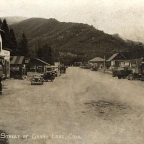
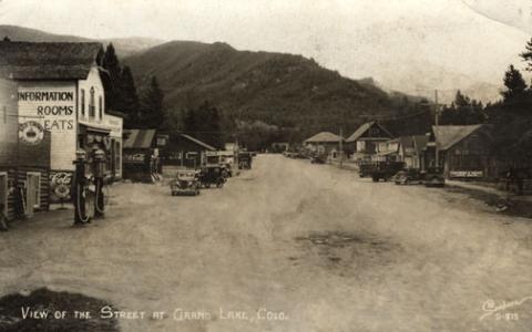
Fire Engine No 1 - Hideaway Park Fire Department

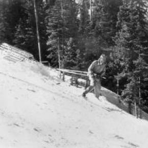
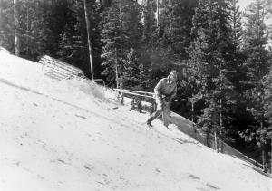
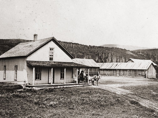
"What Hideaway Park needs is a fire engine!  No way can we fight fires without more water; all we can do is watch some building burn!"  The half dozen volunteer firefighters were seated around the table in Hildebrand's little grocery store on Highway 40. "I agree," said Ray.  "We've talked long enough!  Who's got the want ads?"

Claude pulled out the latest Denver Post want ads.   "I don't see any fire engines.  I looked up fire fighting equipment too.  Nothing there.  But here's a 1940 Chevy truck for $400.00.  That's just eight years old; maybe it would do."

"We could mount a tank and a pump on the back," said Dwight.  "Do we have enough money to pay for it?" Claude pulled out their account book.  " We've $550.00.  That would pay for the truck and we volunteers could use the rest to put up a shed.  We can always have more Bingo nights.

"Dwight, you're the Fire Chief.  Why don't you and Ray go down and look at it.  We'll give you a blank check so you can bring it home if it looks good." The men agreed.  At last they were getting started.

The following week Dwight and Ray drove to Denver to the car lot and took a look.  The truck wasn't much, but the engine worked and the tires weren't too bad.  Ray commented, "I know a fellow who has a galvanized tank.  We can buy some 2" hose and a pump from American LaFrance.

"Okay," said Dwight.  "Let's take it."   He brought out the check Claude had sent along and signed it.  The used truck salesman looked at it and looked at Dwight.    "How old are you, Mr. Miller?"

"I'm 20 years old," he answered.  "What's the problem?  I'm Fire Chief."

"Hmph, you look more like sixteen!  We're not supposed to take checks from anybody younger than 21.  Let me go talk to the bookkeeper."   It took a long time and Dwight and Ray were getting nervous.  At last the salesman returned.  They'd accept the check.

And so Hideaway Park got its very first fire truck.  The men in town finally got the tank and pump put together and started in on a wooden building, along the main road off Highway 40 where Cooper Creek is now.  Winter came early that year, and the fellows didn't have time to get the roof completed.  The rafters and sheeting were up, but the 90# roofing material had to wait; so snow drifted in with every storm, and ice built up, to melt and leak later onto the truck.  But the men knew they could finish up the following year.   Periodically they got together to try out the pump and drive up and down through town, with their new siren wailing.  Everything seemed to work.

A few years passed.  When fires occurred, however, the buildings still usually burned to the ground. One winter in 1952, Dwight was wakened before midnight.  "The Spot is burning.  Let's go!  Let's go!"  Ray's voice broke with excitement.  Dwight jumped from bed and threw on his clothes.  He could see the flames down on the highway leaping above the trees.

Men were gathering at the firehouse. Dwight ran through the door and clambered up on the fire truck.   He tried to start the engine.  R-r-r-r --.  Nothing happened.  R-r-r-r.   "The battery is dead," he cried. 

Ray and Wally were struggling to get the overhead door open and the miserable thing was frozen shut!  They took a hammer to the base, but the frost wasn't about to give way and let door move.  Finally Dwight cried, "Let's slip a cable under the door and hook it to the truck.  We can pull the truck out and on down to Vasquez, to fill the tank." 

The cable was soon in place and Claude jumped into his truck and started pulling.  With the fire truck in gear, it moved forward, hit the double garage door, and continued on.  With a groan and a jerk, the engine and siren  finally started.  Dwight guided the rig onto the road with the door riding on top of it, blinding him.  At last, the door fell to the ground.

At the creek, the fellows pulled the hose down to the water and chopped a hole in the ice.  Another started to hook the hose onto the pump.  "The hose has shrunk!  It won't fit!"

 "What?  It did the last time we practiced!"  The volunteers looked at each other and threw up their hands in disgust. The Spot to Stop was burning fiercely by this time, but Ray said, "Let me string my garden hose across the highway.  I think it's long enough, and maybe it will do some good."  This is what he did, but it was too late.  That building was a goner. 

The townspeople stood around until there was nothing left but ashes; then they went home to bed.  The firemen met the next morning to decide what to do about the truck.  They eventually chose just to leave it there all winter.  It sure wasn't going to do anybody any good.  The next winter, that fire truck had a new hose!

Some years later, Dwight and Jean Miller gave land for a volunteer fire building, which was made of metal and which had a heater.  And over the years, better trucks were purchased and the men received some proper training.  The early volunteers had a perfect record ? they never saved a building.

Some of the volunteers in 1947-48; there may be others.  
Dwight Miller
Ray Hildebrand
Claude Brock
Bill Polk
Jim Quinn
Wally Tunstead
Easy Butler
Leroy Hauptman
Dick Mulligan, Jr.

Grand Lake's First Fireboat

During the summer of 1960, Jeff E. Fuller and Don Drake formed Mountain Services Inc. to offer Grand Lake shore owners protection by patrolling the properties.  In May of 1961, Don Drake promoted the idea of a fireboat and with donations, a 1960 18 foot Buehler Turbocraft Jet 56 was purchased and equipped to fight fires. Don tested the water jet and found that it would pump enough water to reach the fourth story of the five story-14 bedroom Oscar Malo home. 

Ironically, on September 10, 1961, that very home caught on fire.  The home was completely engulfed by the time Don got the fireboat to the location but, with the help of Elmer Badger and Jerry Gruber, they concentrated on the 4-slip boathouse.  The heat was so intense it melted the plastic trim on the fireboat but the boathouse was saved and still stands today.


Articles to Browse

Topic: Mining

Dutch Town

When two Germans, having imbibed too liberally shot up the mining town of Lulu City, they were run out of town.  They went higher and established camp, on the side of Red Mountain near timberline.  There they found a lode of low grade gold, silver and lead.

While it lasted only two years, this encampment came to be called "Dutch Town".  Gradually the fierce winters and lower quality of ore drove the settlers out, leaving only a few empty cabins about a mile west of Lulu City. 


Topic: Towns

Parshall

The town-site of Parshall was part of the ranch homesteaded by Fred Dean in the 1880s. Before 1900 the ranch belonged to William Byers, founder of the Rocky Mountain News and town of Hot Sulphur Springs. In 1902 Frank Byers, son of William Byers, sold the ranch of 480 acres to Cordelia and Simon Parshall.   

Cordelia Parshall died on March 30, 1904, leaving the ranch to her son Clyde. In 1907 Clyde sold 60.6 acres of the northeast corner of the ranch to Alonzo F. Polhamus, a civil engineer. Polhamus dedicated the town plat to Grand County on July 26, 1907 and named it for his friend and the Parshall homestead. The original primitive store operated by Walter Dow was the drawing card for visitors. Parshall was the headquarters of the “Williams Fork Telephone Company,” a highly informal operation that is said to have transmitted its subscribers’ voices along barbed wire fences.

The town was never incorporated and today still has a bar and restaurant, a post office and a chapel, plus the Grand County Road and Bridge Dept. District 3 maintenance shops. Population varies seasonally between 75 and 90 people.

Edits and corrections to original posting by Don Dailey, 10-2021.


Topic: Mountains

Mount Craig

The rounded mountain at the head of the East Inlet to Grand Lake has born many names-from Middle Mountain, to Mount Baldy, to Mount Westcott. It's official title, however, is Mount Craig. It's namesake is The Reverend William Bayard Craig, who came to the area in 1882, to be pastor of the Central Christian Church in Denver. He visited Grand Lake occasionally, and completed some real estate dealings there. The town of Craig also bears his name, due to the influence of his friend, David Moffat, of the Denver and Salt Lake Railroad.

Topic: Mountains

Rollins or Corona - What shall it be called?

Travel across various passes of the Continental Divide occurred long before white men showed up. Indeed, as anthropologist James Benedict wrote c. 1975, some 10,000 years ago, prehistoric Indians camped, hunted, and built hunting walls on the upper reaches of Rollins Pass, as well as moving in and out of Middle Park for the warm summer months.

Historic Indians followed the same paths. In the earliest days of non-Indian access, a particular pass at the head of Boulder Creek was dubbed Boulder Pass. Capt. Jacob Bonesteel, including wagons, made the first recorded crossing by a white man at this point in April 1862. Three years later, a group of Mormons brought wagons over this route and a year later, promoters of new roads into Middle Park brought in many wagons and livestock.

In fact, tourists were starting to enter the park by a number of routes, and one of them, Samuel Bowles, who wrote a fascinating account of his trip, including his return to Denver via Boulder Pass. Interest was growing rapidly for a road over the Divide, into Hot Sulphur Springs, and on into Utah. One promoter, John Quincy Adams Rollins, from New Hampshire, teamed up with William N. Byers and Porter M. Smart to carry this project through. Rollins was interested in crossing the Divide; Byers was promoting the Springs; Porter wanted to develop the valley of the Middle Yampa. All three were pushing to have Middle Park officially named as Grand County, a challenge finally accomplished in 1874. So Rollins and associates started his road, reaching the top in 1873.

That next winter, they publicized this access and in June, Jimmy Crawford brought his family and wagons to Rollinsville and thence to Yankee Doodle Lake, ready to cross the pass now named Rollins Pass by the developer. But the road ended, and they found Rollins' men still hacking the road out of the granite! Jimmy and his crew found it necessary to leave their wagons and help. Finally, on June 10th, the family was able to head for the top. Jimmy borrowed two yokes of oxen, hitching them to mules, and then to his horse. The road was so rough that the procession could proceed but a few feet before having to rest. The family itself climbed on foot. At the summit, they discovered only a rough swath cut down through the trees on the western side. The "road" dropped down between the lakes and followed Ranch Creek to its junction with the Fraser River.

Rollins quickly realized that Berthoud Pass, which also opened in 1874, was superior to his own pass for wheeled vehicles, so he determined to hedge his bets. He initiated the first mail service into the county in 1873. He also built a commodious hotel where his road joined the Berthoud Pass road at the confluence of Crooked Creek and the Fraser. He called it the Junction House. Next, he proposed to the builders of Berthoud Pass that they form a joint ownership of the two roads between Junction Ranch and the Springs. Tickets would be issued for both routes and revenues would be shared. The two companies would build a bridge over the Grand at Hot Sulphur Springs. He even buttered up his rivals by complementing their work. All this was accomplished, although the mail route soon moved to Berthoud Pass, because of the severe winters on Rollins Pass.

The bridge was started in November 1874. From the beginning, Rollins' road was preferred for trailing livestock, because there were fewer problems with heavy timber and bogs. For years, the Church brothers, George and John, who introduced the Hereford breed into the county, trailed their cattle for summering in what became known as Church Park. However, tourists such as Irving Hale still drove wagons over Rollins Pass in 1878. About 1880, interest burgeoned for bringing a railroad up South Boulder Canyon and through a tunnel near Rollins Pass. Numerous surveys were completed all along the area. David Moffat settled on Rollins Pass for the tunnel site but decided first to put a temporary line over the top.

Thus, in the summer of 1903, a formal contract was let for work up and over the Pass itself. By 1904, the workers reached Arrowhead and they also built a work station on top, called Corona Station, or "crown of the mountain." This railroad construction town of Corona, located at over 11,600 feet at the top of Rollins Pass (first called Boulder Pass) along the Continental Divide was the highest railroad station in the world. It became obvious by 1905 that the Corona area would require snowsheds if trains were to travel, even irregularly, during the winter. Still, word got out of the spectacular splendor of Rollins Pass and tourists flocked in on summer train excursions, sometimes stopping on top, sometimes going as far as Arrow.

In 1913, a fine hotel was built next to the rail facilities. Because Rollins Pass was right in the middle of severe weather patterns, a weather station was built on top, as well as one down at Sunnyside. In 1915, Rollins Pass was actually proposed to be the south boundary of a proposed "Estes National Park." Later, on the National Historic Register, the district was listed in 1997 as the Denver, Northwestern and Pacific Railway Historic District--Rollinsville & Middle Park Wagon Road. It was also identified as the Rollinsville and Middle Park Wagon Road; Boulder Wagon Road, Rollins Pass, and Rollinsville area. In 1956, Governor Steve McNichols had presided at the official re-opening of the four percent grade to vehicle traffic over Corona Pass, expressing the hope that the route would someday be paved. The Colorado Game and Fish Department and the U.S. Forest Service made additional improvements, and the Arapaho and Roosevelt National Forests put out a 24-page booklet titled "The Moffat Road: A Self-Guiding Auto Tour."

The road crossed two of the original railroad trestles near Corona but those trestles, even if reached by 4-wheel vehicles, were crumbling and could no longer even be crossed safely on foot. The current self-guided auto tour refers to Rollins Pass, as well as the Moffat Road and the Boulder Wagon Road. Corona Station and Hotel are discussed. In 1979, a portion of the auto road over Corona Pass was permanently closed because of a cave-in of the "Needle's Eye," a tunnel located before the trestles heading west from the Moffat Tunnel's East Portal. The tunnel reopened on July 3, 1988, thanks to efforts of the Rollins Pass Restoration Association on both sides of the Divide, with the cooperation of the U.S. Forest Service, Colorado History Society, and Boulder, Grand, and Gilpin Counties. It then closed once more when another rockfall hit the tunnel on July 15, 1990. The RPRA is continuing its efforts for re-opening. The noted photographer, Charles McClure, took many outstanding photos of the Rollins Pass road.

One, titled "Group on Rollins Pass, shows well-dressed men and women stand on a snowfield making snowballs on Rollins Pass, Moffat Road, Boulder or Grand County, Colorado; probably on Denver, Northwestern and Pacific excursion train. Date: between 1904 and 1913 near Corona Station." Another photo shows a "30 ft. snowcut on Rollins Pass, Moffat Road photo. Denver and Salt Lake Arrow passenger car is parked east of Corona snowshed by the thirty foot snowbank cut, Rollins Pass, Colorado; it shows men, women and railroad employees posed behind train, on the roof and on the snowbank and a standard gauge track. Date: between 1904 and 1915." A sign at the highway turn onto the Moffat roadbed says: The Moffat Road "Hill Route" Also called "Corona Pass Road", this road over the Continental Divide was the original "Hill Route" of the Denver, Northwestern & Pacific Railway built by David H. Moffat in 1903. It crosses Rollins Pass at 11,666 feet elevation. On top of Rollins Pass, a sign says: Elevation 11, 660 feet, John Quincy Adams Rollins established a toll wagon road through this pass in the mid 1870's. David H. Moffat's Denver, Northwestern & Pacific Railway crossed the Continental Divide at this point in 1903.

First known as Boulder Pass, then Rollins Pass, the railroad workers dubbed it "Corona", the crown of the "Top of the world." A railroad station, hotel, restaurant and workers' quarters existed here until 1928 when the railroad was abandoned due to the building of the Moffat Tunnel. Identifications in various trail and geographical guides say: Rollins Pass (el. 11,680 ft) is a high mountain pass in the Rocky Mountains of north-central Colorado in the United States. The pass is located on the continental divide at the crest of the Front Range southwest of Boulder, at the boundary of Grand County, Colorado and Boulder County, Colorado. Rollins Pass (a.k.a. Corona Pass) sits approximately 5 miles east and above the popular ski areas around Winter Park, between Winter Park and Rollinsville. The pass is traversed by an unpaved road, mostly the former roadbed of the Denver and Salt Lake Railway which abandoned the route in 1928 when the Moffat Tunnel opened to replace it. Railroad advertising called this the "Top O' the World" and it referred to the Moffat Route over the continental divide and the Rocky Mountains. Rollins Pass was the primary travel route west from Denver until an easier road over Berthoud Pass was constructed. The Denver, Northwestern and Pacific railroad laid its tracks across the pass in 1903-1904 and established a Depot at Corona on the crest. It can be noted that in R.C. Black's Island in the Rockies, the term "Corona Pass" was mentioned one time, on p. 351; the terms "Corona Station" or "Corona Snowsheds were used. In Dismantling the Rails That Climbed, Rollins Pass was used, the Corona hotel, and just once, Corona Pass; 1936.

In Maggie By My Side, it was Boulder Pass and Rollins Pass. In Rails that Climbed, Rollins Pass, the Corona shed, weather at Corona, Rollins Pass Snow Shed, other references to Corona as a site. In Guide to the Colorado Mountains (Orme) , they speak of the Corona Trail to Rollins Pass. High Country Names (Ward) used Rollins Pass entirely. Only Hiking Grand County, Colorado, published 2002 by Carr speaks of Corona Pass, with reference to Rollins Pass (near the town of Corona), Moffat Road. The term "town" might be questionable; there was only a small restaurant, workers quarters, railroad offices, and in 1913, the hotel. Current maps, USFS and the Grand County Trail Map, show Rollins Pass, with Corona at the side as being a site. The use of "Corona Pass' seems to be a rather recent innovation that has come into being with tourism efforts in the upper Fraser Valley. Rollins Pass From Island in the Rockies p. 45 Rollins Pass was originally known as Boulder Pass, first recorded being crossed by whites, by Capt. Jacob Bonesteel in April 1862. Their supplies were carried in wagons. A second organized party went over the same pass in 1865. In 1866, promoters of access into Grand County brought many wagons and livestock over Boulder Pass.In 1867, Samuel Bowles and a group returned home to Denver via Boulder Pass. In 1873-74, two roads were proposed into the county, one of Berthouds pass and one over Boulder Pass. This was the same time that the county was named "Grand". J..A Rollins and his associates started the road and reached the top of the pass in 1873, at which time they envisaged a road from HSS into Utah. The first wagons went over in June 1874. The western descent was so bad that it never was much patronized by wheeled vehicles, instead becoming primarily used for trailing of cattle. At this time the name Boulder Pass disappeared from maps and Rollins Pass became the official name. p. 85. p. 80 Lots of schemes to build roads into GC, but of all the schemes for transport, only one, the Rollinsville and Middle Park Wagon Road showed any promise. T

hat was designed by John Quincy Adams Rollins, from NH, a gifted promoter, a son of a clergyman, second of 19 children. He was a farmer, miner, freighter, road bulder, and platter of towns. He was perhaps the most accomplished billiard player west of the Mississippi. He was a Colorado resident at least by 1866. His finances were up and down, but he was tremendously strong. In December 1884, when he was 68, he thought nothing of a 3-day snow-clogged crossing of the Continental Divide. p. 85 Rollins was interested in MP as an investor and he was interested in extending his road into Utah.. At the same time, a Porter M. Smart was likewise excited about speculating in frontier projects and was working at developing the valley of the Middle Yampa. William N. Byers was busy planning for HSS. These three men launched at least two petitions, with more than 80 "residents" for creating GC. Grand County was created that year, 1874. p. 89 With the creation of GC, people began to consider the area more seriously. p. 92 There was no official mail into the county until 1873 when Rollins brought in the first US pouch over his pass. In May 1874, he built a commodious hotel at the confluence of Crooked Creek and the Fraser, known as the Junction House. p. 94 Rollins knew that the road over Berthoud Pass was superior to Rollins Pass; his main advantage was the railhead at Blackhawk.

So Rollins proposed a joint ownership and operation of the two roads for the line between Junction Ranch and HSS. Tickets would be issued for both routes and revenues would be shared. The two companies would build a bridge across the Grand at HSS. Rollins even complimented the Berthoud work. This merger was completed soon. p. 104 This bridge was started in November 1874. p. 108 A mail contract was made in July 1875 for once a week delivery over Rollins Pass, but conditions were so severe that the route was changed to Berthoud Pass. p. 110 From the beginning, Rollins Pass was used in preference to Berthoud Pass for trailing livestock, because there were fewer problems with timber and bogs. However, late spring snowdrifts were a problem, so 20-30 horses were often brought along to break trail. The Church brothers, ?George and John, summered their cattle in what became known as Church Park and dug the Church Ditch. They also introduced the celebrated Hereford breed into GC. p. 170-171 As interest in bringing a railroad into and through GC developed, about 1880, various stockholders proposed to build up South Boulder Canyon to Yankee Doodle Lake and start a tunnel near Rollins Pass. Nothing came of the first attempts but by the end of July 1881, numerous surveys had been made for that tunnel. p. 238 Cattle was still being trailed out via Rollins Pass up to the turn of the century. p. 258 David Moffat and Horace Sumner, his chief engineer, in the fall of 1903, were planning the tunnel for future excavation; but in the meantime a temporary line was planned for crissing Rollins Pass, at 11,640 feet. p. 264 A formal contract was let for the work over Rollins Pass in August 1903. The loftiest sections were started first, and the first cuts at the top were nearly finished by the 26th of October and tunneling started at Riflesight Notch. As snow came, work slowed to a standstill. p. 265 Work in 1904 was extremely slow until the end of August.

An encampment was built at Arrowhead and a station at the crest of the Divide was named Corona Station, where long snow sheds were built almost immediately. p. 267 Arrowhead was soon shortened to Arrow, when a post office was opened there in 1905. Travel on the grades, at 4-5% grades up over Rollins Pass was exceedingly difficult. p. 270 In 1908, word of the scenic splendor of Rollins Pass was becoming known world wide. Also, Rollins Pass and its "Corona station" were attracting the attention fo the US Weather Bureau, for the pass lay squarely in the center of the region of heaviest snowfall on the entire Colorado Continental Divide. p. 344 A terrible winter in 1909 made people think that Rollins Pass was never going to be practical for the long term. Time and again freight and passengers were stuck on top at the Corona facility. In 1913, a $10,000 hotel was built at Corona next to the rail facilities. From Dismantling the Rails That Climbed p. 6 The railroad went from Denver to the top of Rollins Pass. p. 8 Snowsheds were built over the tracks at Corona and other strategic places in 1905. p. 12 The top was referred to as "Corona Pass" 1936. p. 16 Crews who were to removed tails and ties reached Corona at the top of Rollins Pass 1936. p. 20 Reference to the Corona hotel From Maggie By My Side p. 1 Jimmy Crawford heard that a man named John Quincy Adams Rollins was building a road over the range at a place called Boulder Pass. 1873 p. 9-14 June 1874 The Crawford family traveled to Rollinsville and then to Yankee Doodle Lake, where the road ended. Rollins' men were still hacking the road out of the granite. Jimmy and his crew helped. On the morning of June 10, the family started out to go over the rocks and up the mountain. Then he borrowed two yokes of oxen to his wagon, then mules, then his horse. The animals had to rest every few feet; the family climbed on foot. There was no shelter at the top. Rollins' men had done no work yet on the west side of the pass except to cut a rough swath down through the trees. The road dropped down along Ranch Creek. From Rails That Climb published 1950 p. 43 Leyden Junction to Tolland to Rollins Pass. P. 63-64 Many references to Tunnels as identifiers of location. p. 76-77, 78 reference to the old Rollins Pass toll road; first mention of the place called Corona- crown of the mountain. Most references are to Rollins Pass. The Corona shed is mentioned, p. 82. p. 83 Sunnyside water stop, Loop Trestle and Tunnel, Ranch Creek Trestle and water stop, Arrow. p. 95, 100- 101 It is eleven miles from Arrowhead to Rollins Pass. Rollins Pass-Boulder wagon road; other references p. 107 - 112 reference to Corona shed. Reference to pipe line to Corona; a number of comments to Rollins Pass p. 119 weather at Corona p. 120-121 Rollins Pass p. 151 Rollins Pass p. 182 photo of "Rollins Pass Snow Shed" "This Corona station burned one night." p. 188 photo of June at Rollins Pass p. 192-194 photos of Corona shed and other buildings; Rollins Pass p. 252 walking on top of snow shed at Corona p. 271- 272. 1910 Snowshed at Corona p. 312-314 Rollins Pass; Rollins Pass snowshed; Corona; Corona siding p. 324 Corona; Sunnyside weather report station p. 326 Corona sheds p. 333-335 Corona shed; references to "Corona" as a place From Guide to the Colorado Mountains published 1974 p. 54-55 Corona Trail, going from East Portal to Rollins Pass From High Country Names published 1972 p. 105 Irving Hale in 1878 drove his wagon over Rollins Pass, now nearly abandoned as a wagon road. p. 131 David Moffat decides to build a temporary line over Rollins Pass. p. 165 In 1915, Rollins Pass was proposed to be the south boundary of a proposed "Estes National Park". From Hiking Grand County, Colorado published 2002 p. 52 Trailhead on the "Moffat Road to Corona Pass". In same paragraph, it becomes Rollins Pass (near the town of Corona). On p. 54, reference to the Corona Road. On p. 57, map shows Rollins Pass with Corona marked as a "site." p. 56, reference to the old railroad bed used crossing the Divide at Rollins Pass, near the town of Corona.

Sometimes called Corona Pass. p. 60-61 Rollins Pass Wagon Road historical notes on JQA Rollins and how to find his wagon road over Rollins Pass, following Ranch Creek to Tabernash. p. 66 Rollins Pass (Corona) to Devil's Thumb From GCHA Journal The Journey p. 6 Rollins Pass used by Indians; comment in 1981 From GCHA Journal Middle Park Indians to 1881 p. 8 Archaic hunters camped in the Rollins Pass area; written mid-1970's The current maps, USFS and Grand County Trail Map, show Rollins Pass with Corona at the side as being a site. The Rollins Pass Restoration Association for many years, and currently, has been trying to open the road and Needles Eye Tunnel. The self-guided auto tour refers to Rollins Pass, as well as the Moffat Road and the Boulder Wagon Road. Corona Station and Hotel are discussed. On the National Historic Register Denver, Northwestern and Pacific Railway Historic District--Rollinsville & Middle Park Wagon Road (Boundary Increase) ** (added 1997 - District - #97001114) Also known as Rollinsville and Middle Park Wagon Road;Boulder Wagon Road;R Rollins Pass, Rollinsville Corona Station and Hotel The railroad construction town of Corona, Colorado, located at over 11,600 feet at the top Corona Pass (first called Boulder Pass) along the Continental Divide was the highest railroad station in the world. It was situated on an old Native American trail, the same trail it is believed the Mormons traveled on their way to Utah. The road was improved by the U.S. Army, then further improved in 1866 by General John Q. Rollins, for whom the pass and the town of Rollinsville were officially named. Because of the high drifts of snow, the pass was only open from around July to the first big snowstorm two or three months later. In 1956, Governor Steve McNichols presided at the official re-opening of the four percent grade to vehicle traffic over Corona Pass, expressing the hope that the route would someday be paved. The Colorado Game and Fish Department and the U.S. Forest Service made additional improvements, and the Arapaho and Roosevelt National Forests put out a 24-page booklet titled "The Moffat Road: A Self-Guiding Auto Tour."

The road crossed two of the original railroad trestles near Corona but those trestles, even if reached by 4-wheel vehicles, are crumbling and can no longer even be crossed safely on foot. In 1979, a portion of the auto road over Corona Pass was permanently closed because of a cave-in of the "Needle's Eye," a tunnel that came before the trestles on a westward drive from the Moffat Tunnel's East Portal area. The tunnel reopened on July 3, 1988, thanks to the efforts of the Rollins Pass Restoration Association with the cooperation of the U.S. Forest Service, Colorado History Society, and Boulder, Grand, and Gilpin Counties. It was then closed once more when another rockfall hit the tunnel on July 15, 1990. John K. Aldrich is a geologist, lecturer, and author whose "Ghosts of . . . " books and accompanying topo maps are a boon to hobbyists, explorers, and those interested in Colorado mining history. Date: 02/04/08 05:13 Rollins Pass Milepost 16 Corona Station. Picture 6 below, is DPL photo X-7388. "Title: Corona, Colorado, interior of snowshed. Summary: Passengers stand next to the covered train depot at Rollins Pass, in Corona (Grand County), Colorado. The tracks of the Denver, Northwestern & Pacific Railway are in the foreground. The depot is constructed of logs, and the roof of the snowshed is upheld by timbers. Sunlight streams through the opening at the end of the snowshed. Date: (between 1904 and 1913). Source: E. T. Bollinger from W. I. Hoklas." Picture 7 below, is DPL photo MCC-454A. "Title: Group on Rollins Pass. Summary: Well dressed men and women stand on a snowfield making snowballs, Rollins Pass, Moffat Road, Boulder or Grand County, Colorado; probably on Denver, Northwestern and Pacific excursion train. Date: (between 1904 and 1913). Creator: Louis Charles McClure 1867-1957. Picture 8 below, is DPL photo MCC-624. "Title: 30 ft. snowcut, Rollins Pass, Moffat Road photo. Summary: Denver and Salt Lake Arrow Turn (passenger car) parked east of Corona snowshed by thirty foot snowbank cut, Rollins Pass, Colorado; shows men, women and railroad employees posed behind train, on roof and on snowbank and standard gauge track. Date: (between 1904 and 1915 The highway sign says The Moffat Road "Hill Route" Also called "Corona Pass Road", this road over the Continental Divide was the original "Hill Route" of the Denver, Northwestern & Pacific Railway built by David H. Moffat in 1903. It crosses Rollins Pass at 11,666 feet elevation. On top of Rollins Pass, a sign says: Rollins Pass Elevation 11, 660 feet John Quincy Adams Rollins established a toll wagon road through this pass in the mid 1860-s. David H. Moffat's Denver, Northwestern & Pacific Railway crossed the Continental Divide at this point in 1903. First known as Boulder Pass, then Rollins Pass, the railroad workers dubbed it "Corona", the crown of the "Top of the world." A railroad station, hotel, restaurant and workers' quarters existed here until 1928 when the railroad was abandoned due to the building of the Moffat Tunnel. Rollins Pass Elevation 11,680 ft (3,560.1 m) Traversed by Unpaved road Location Boulder_County,_Colorado / Grand,Colorado Rollins Pass (el. 11,680 ft) is a high mountain pass in the Rocky Mountains of north-central Colorado in the United States. The pass is located on the continental divide at the crest of the Front Range southwest of Boulder at the boundary of Grand_County,_Colorado and Boulder County. Sign that sits on top of Rollins Pass Rollins Pass (a.k.a. Corona Pass) sits approximately 5 miles east and above the popular ski areas around Winter Park, between Winter Park and Rollinsville. The pass is traversed by an unpaved road, mostly the former roadbed of the Denver and Salt Lake RailwayDenver_and_Salt_Lake_Railway which abandoned the route in 1928 when the Moffat Tunnel opened to replace it. Rollins Pass Railroad advertising called this the "Top 'O the World" and it referred to the Moffat Route over the continental divide and the Rocky Mountains. Rollins Pass was the primary travel route west from Denver until an easier road over Berthoud Pass was constructed. The Denver, Northwestern and Pacific railroad laid its tracks across the pass in 1903-1904 and established a Depot at Corona on the crest. David Moffat planned to replace the "Hill Line" with a tunnel through James Peak within a few years of the railroad construction. However, he never could obtain financing for the tunnel due to the inability of the railroad to make a profit and opposition from competing railroads such as the Denver and Rio Grande. The D&RG saw the line as a threat. But, in the far future the construction of Moffat Tunnel would turn out to be the D&RG's saving grace.

The trip up Rollins Pass was a favorite of summer tourists looking to enjoy the mountain scenery. It was heavily promoted by the railroad with picnic and wildflower picking excursions. Sights along the line were made famous by postcards containing the photos of L. C. McClure. At last the route surmounts the crest of the Continental Divide and takes quick refuge on the top at Corona. At elevation 11, 660 this is truly the famous Top O' the World and one of the highest railroad passes in the world. Due to the great height and nature of the Rocky Mountains, the entire railroad complex was completely enclosed in giant covered snow sheds.

Topic: Leisure Time

Leisure Time

Of all the leisure time activities available to the pioneers, dancing was the favorite. Dances were held in grand hotels that remained from the mining boom, such as the Fairview House and The Garrison House in Grand Lake. Quadrilles, a type of square dance, were popular at the time. A fiddler would provide the music and serve as the caller. These parties would start in the evening and last all night.

The formidable temperatures and great traveling distances were incentive for getting the most out of every gathering. Winter Sports have also always been a popular pastime. Skiing was introduced to the region during the winter of 1883. Snowshoeing and sleigh rides were also enjoyed. 1882 officially brought the arts to the Grand Lake area when the Dramatic Society was organized. A production of the well-known comedy "Our Boys" was the premiere performance.

Topic: True Crime

Sudden Death in Old Arrow

A shooting in the Old West I know was not much like the shootings on television today.  There was no glorification of the bad man. Killings were usually like the fatal shooting of Indian Tom on that 6th of September, 1906, in old Arrowhead (or Arrow).  Nobody called anybody out.  Nobody told anybody to draw or asked him if he was wearing a gun.  It wasn’t a fight. It was a killing.  

1906 Arrow had six saloons, a grocery store, one small hotel and a livery stable.  But two thousand people picked up their mail there.  The woods were full of tie-hacks: the three sawmills hired may lumberjacks and teamsters, most of them Swedes, who seemed to make the best lumbermen.   I had arrived in Arrow the 18th of April that year to work as a teamster for my brother Virgil, who had been operating a sawmill there for about a year.  I was just sixteen. 

My brother Dick, the tallest Lininger, had been Virgil’s foreman.  Virgil had also bought the only hotel in Arrow.  My mother, two sisters and my little brother Gilbert and I came from our farm in Osawatomie, Kansas, so that my mother could run the hotel. My brother Wesley came at that time too: he planned to buy a lot and build a café.  Whole families often followed the first member who had come to these early Colorado towns.   I soon discovered that driving logging horses needed a lot more technique than driving a small farm team, but Virgil was patient, and I soon received a raise to $2.75 a day as top teamster.  

 The town was a wide open as it could get.  My first introduction to the violence was the day my brother Dick fired three drunken lumberjacks.  They drew their pay and went to Graham’s saloon to get drunker. As dick passed the saloon later, one of the men grabbed a quart whiskey bottle, and ran out and struck Dick behind the ear, knocking him cold.  The three then proceeded to kick him around.  Dick’s roommate Charley came to my brother’s rescue.  When Dick came to, he started for the hotel.  Charley guessed what he was after and beat him to the six-shooter. “I’ll make sure you can taken them one at a time” Charley promised him.   I came along just as my brother knocked the pick from the pick handle.  Something was up! In less time than it takes to tell it, Dick had three drunks out cold. 

Mother patched Dick up.  I think this was her introduction, too.  A man couldn’t stay boss long if stayed whipped.   Every other Sunday was a holiday for me although I always saw to it that I put in enough overtime to bring my monthly paycheck to $75. That September Sunday I was dressed in my holiday garb – tan peg-top dress corduroys, light blue wool shirt, Western hat, and high-laces boots as befitting a teamster who drove four or six horses hauling logs from timber country to the saw mill.  When I drove six horses, I rode one of the wheel-team horses and held the lines over four.  If I drove four horses, I rode the wagon and sat on a sack of hay.  

About noon, I stopped in front of the MacDonald saloon to talk to Ed MacDonald, one of the few saloon men my mother didn’t disapprove of.  After all, Ed had come to Colorado as a TB and couldn’t do heavy work; filling glasses over a bar was about the only light work in those old mountain towns.  Later Ed owned the famous MacDonald Ranch on the South Fork of the Grand Rover – now Colorado River- and managed boats on Monarch Lake just above his ranch.  He always served great dinners and good food.   While Ed and I were talking, Indian Tom rode up.  He was a flashy cowboy of the old school, a very good looking man with predominantly Indian features although he was only half Cherokee. When riding, Tom always wore leather chaps, spurs, and a big Stetson.  As wagon foreman for Orman and Crook, contractors for building the Moffat Road, he was a very important figure, for he had charge of all their wagons and teamsters.   The greeting between Ed and Tom was cordial. 

Everyone liked Indian Tom.  When Tom learned I was a teamster for my brother Virgil, Tom showed a much keener interest and invited me in to MacDonald’s for a drink.  Ed rescued me.  “Oh the kids doesn’t drink; but he might like a cigar”.   As they ordered drinks, I puffed away in my best imitation of a Kentucky colonel; however I soon excused myself, saying that I had to target my 30-30 rifle for the upcoming deer season. I puffed until I was out of sight. The corn silk I had scorched behind the barn paid off. I didn’t disgrace myself, nor had I broken my pledge to my mother not to gamble, use profanity, drink, or perform any act inconsistent with the conduct of a gentleman.   I took my rifle northwest of Arrow to Fawn Creek. 

It was a beautiful fall day.  The aspen were just beginning to turn.  Fawn Creek Gulch had been burned over many years before by the Indians who hoped in this way to discourage settlers, and the aspen were all young, straight and shimmering in the way that has never ceased to delight me.  The fire thirty years before had made the gulch an excellent place for deer hunting because the new growth gave the deer some inviting protection, but the terrain was open enough for a hunter to locate his game.   I figured I’d have to shoot from at least 200 yards, so I planned to target for that distance.  I tacked a piece of cardboard I’d cut from my brother’s Stetson hat box (he never took off his Stetson off anyway) to a tree and stepped off the 200 yards.  That 6-inch target looked pretty small but after each three shots, I’d examine the target.  Finally satisfied, I took a long walk looking for deer sign, tracks, or droppings.  I found good sign but no droppings.   About feeding time for the horses, I went back to the barn in town to feed the four, Cap, the big bay, Bird, the glossy black (those were my two wheel horses- t e ones next to the wheel); Kate, the little lead horse; and Bud, her mate.  

Virgil had bought Kate, a grey mare weighing about 1400 pounds, at a very reasonable price from the Adams Express Company because she had run away at every opportunity and had destroyed several wagons.  He couldn’t run away now pulling Cap, Bird and a load of lumber with her, but her high spirits made her an excellent leader. The heavier team, always used as the wheel team, weighed about 1700 pounds each.   I was very proud of this unusually fine team.  Virgil had trained Cap and Bird so that after they were harnessed in the barn, they could be turned loose to go to the watering trough, drink long and thirstily, then walk out to the wagon, back into position by the tongue, and stand ready to have the breast straps snapped in place and the tongue attached.     When tourists trains stopped and hundreds of passengers stood around the eating places looking the town over, I’d drive slowly by, and then stop to rest the team a minute, to give the dudes a chance to see a good, four-horse team. Then with a single “Yup!” I’d pull all the lines tight, and they’d start as one horse while the tourists explained and pointed.  

That Sunday after I put a gallon of oats in their food box and shook some hay into their manger, I left the barn and started up the steps alongside the depot.  It was still light; the sky hadn’t even begun to color.   Time to head home for supper.  I’d have to be up, hitched and pulled by seven the next morning. We’d probably have roast beef or roast chicken with noodles, since it was Sunday.  Mother would be cooking on the big wood-burning stove at the hotel, and my sisters would be taking the heaping platters to the tables where everyone would pass them around.  Probably there would be hot biscuits.  

Suddenly a shot cracked just above me and across the street.  I knew instantly it had come from the Wolf Saloon ahead.  It wasn’t common to hear shots in those days.  You hear more in a 20-minute Western on TV than you heard in a couple of years unless a few boys rode into town on a Saturday night to shoot up the air.   I broke into a run and could see a man lying on the board walk in front of the saloon.  As I got to him, one of the ladies I wasn’t permitted to mention came out and fell to her knees beside him. Raising the man’s head, she tried to pour whiskey down his throat.  With a queer, paralyzed feeling, I realized it was Indian Tom.  I reached for his wrist.  His hand was warm as life, but there was no pulse. Several men ran our.  “Ragland got him!” one of them shouted.  

We carried Tom’s body into MacDonald’s and laid him on a roulette table that was in the back room for repair.  Somebody went to wire for the sheriff at Hot Sulphur Springs.  Word soon reached Orman and Crook’s, and the Indian’s many friends began to jam into Arrow.    Indian Tom and Ragland had evidently had words during the afternoon and had quarrels once more before at a rodeo.  The women from the saloon said that when Indian Tom left after the quarrel, Ragland had stationed himself, gun in hand, inside the saloon door.  Everyone agreed that Ragland knew he wouldn’t have had a chance in a fair fight with Tom.  The moment they heard Tom’s spurs outside , Ragland pushed the door slightly open and shot point blank through the aperture along the hinge.  The he ran out the back door.   We searched the town inside and out for Ragland. The sheriff joined is in the search late that night, but we found no trace of him.  Just after midnight a wire came for the sheriff. Ragland had turned himself in at Hot Sulphur.  We learned later he had run to a ranch down below, borrowed a horse and ridden for his life.   A coroner’s jury was called. 

My brother Virgil, named foreman, took a firm stand.  The only verdict he intended to take out of that room was murder, and, after only a few hours, that was their verdict.  After three days, Ragland was released on $3,000 bond posted by his father, but you may be sure he didn’t show himself around Arrow.  His attorney, John A. DeWeese, got a change of venue from Grand County to Jefferson County at Golden, claiming an article in the Middle Park Times of September 7, 1906, reporting the verdict of the coroner’s jury, made it impossible for Ragland to get a fair trial in Hot Sulphur.  The article said in part: Four witnesses for the prosecution, and seven for the Defendant were examined, making eleven in all.  The testimony of the witnesses on both sides failed to show that the shooting was justifiable.  According to the testimony, the fatal shot was fired when Reynolds (Tom) had his revolver in his scabbard and when he did not even see Ragland who was standing opposite the cut-off. (As told to Donna Geyer by A.W. Lininger)                     

Topic: Water

Onahu Creek

Onahu Creek was called Fish Creek and is a tributary of the North Fork of the Colorado River. The name refers to one of the Indian race horses who came up to a campfire to warm himself, and the name means “warms himself“.  The horse ultimately died on Fish Creek and gave his name to the waterway.

Topic: True Crime

The face of the 1883 Grand Lake Commissioner Shooting

By Amy Ackman Project Archaeologist - 2018

I work in Cultural Resource Management (CRM), which means I document any man-made occurrence that is 50 years or older. I’ve recorded anything from prehistoric stone tools to 1940’s cans and glass. As a CRM archaeologist, I’m a data collector. Our job is to protect the archaeological record by gathering data and determining the significance of it.  In 2011, I worked on a project near Jensen, Utah, just across the border from Colorado. During this project, I came across an unmarked grave. There was a headstone, but no name. I eventually found from historical documentation that the grave was that of a man named William Redman.

Redman was the undersheriff who took part in the Grand County Shooting of 1883 that involved three county commissioners, a county clerk, and the sheriff. Three men died during the shootout, two men died of their injuries after the fact, and the sheriff committed suicide out of guilt. Two weeks after the incident, Redman was the only living participant. He was on the run from the law and actively hunted by the Rocky Mountain Detective Association. A full month after the shootout, Redman was found dead in Utah at the side of a road with a bullet in his head.   

I knew Redman was part of the Grand County Shooting and poured over any sources I could get my hands on; books, websites, newspaper articles; any tidbits of information that might answer questions. Like a detective, I wanted to understand how Bill Redman was involved in the gunfight and how he ended up in Utah.  I found the story and a picture of William Redman and I was ecstatic that a site I had recorded was associated with such a tale.

William Redman was ruggedly handsome with high cheek bones and pronounced jaw; the clothes and countenance of a miner. The more I learned about him, the more questions I had. How old was he when the photo was taken? At a time when it was such a privilege to have a photo taken, why is there a photo of him and not other prominent men in the county? I wondered about his motivations. Was he the ruffian newspaper articles touted him to be?  Archaeology is about understanding the past. Most of the time we are forced to interpret the past with only a few pieces of material that are left behind. The more material and data we have, the more we can understand.

In the case of William Redman, there are questions surrounding his death that give rise to the possibility that the man in the grave is not Redman at all. If the opportunity arises to excavate the grave, his photograph will assist in his identification.  Archaeology not only studies the past but works to preserve the past for the future. Now, I hope that a family member of yours is never being researched by an archaeologist for being a ruffian and a murderer. But, like an archaeologist, I would encourage you to preserve as much as possible for those in the future who would care to learn about the past.

A Man Called Blue

“Blue” should have been a grouch, with a name like that.  Nobody who knew him seems to know why he was called this; his real name was Rudolph O. Cogdell.  If one went into his little grocery store in Fraser, although his voice was gruff, he gave a peasant greeting.  He did possess a temper that could be ignited, and if his blood pressure rose, his face turned a brilliant red. 

However, he was kind to his wife, Gladys (Hunnicutt), a local girl, and loving to their daughter, Mary Ellen, who was a “late-comer” (Gladys was over 40 when the baby was born).   On the store front, the sign read Codgell’s Market, which was located facing the highway near what is now Doc Susie Avenue.  Before Blue bought the store in the mid-1940’s, he worked on the Fraser railroad section, and he also owned the Sinclair gas station at the corner of the highway and the main street, about 1940.  

Codgell’s Market was quite small, and the customer base was likewise, for there weren¹t many people in the valley in those days. Three grocery stores competed: R.L. Cogdell¹s Market, The Fraser Mercantile, owned by Frank Carlson, and the Red & White Store, run by Charles Bridge, Sr. There was also a tiny store by the sawmill near “Old Town” Winter Park; that one was operated by Mr. and Mrs. Green.  The economy struggled for many years after the war, and everyone lived on a shoestring.  Thus, prosperous times for any of the grocery stores had marginal potential.  That should have made Blue grumpy, one might think.   Blue, a short, rather stocky man with dark hair and brown eyes framed in glasses and habitually clad in his grocer’s apron, took care of everything in his mercantile except for the meat counter at the rear of the store.  He would be found arranging the goods on shelves, dry goods on one side, dried food on the other, and fresh food in between.  He stored some of the dried foods in barrels along the aisle. Fresh food was picked up once a week.  It was, of course, very seasonal, with only root vegetables, apples, oranges, and bananas being available year-round.

Granby Dairy delivered dairy products; Rube Strachman in Granby sold him meat.  Nobel Mercantile from Denver serviced the dried foods and produce.   Gladys, even shorter and stockier than Blue, had a fiery temper and she was known on occasion to retaliate if some customer gave her any lip.  She was an expert butcher, and if a person wanted some special roast or other cut of meat, he went to see Gladys.  She was good.  Mary Ellen helped when she could, as she grew older.   When the theater, located on the corner of Highway 40 and St. Louis Ave., or Main Street (now Eisenhower Drive) in Fraser closed its doors, Blue bought the building, doubling his available space.  The layout was the same and Gladys still manned the butcher department at the rear of the store. Walking into the long skinny building always brought to mind the movies of previous days. 

The economy improved as the ski area grew.   It was a fact that Blue, although a hard worker, also loved to gamble, and one report speaks of certain crap games.  It seems that there was a stretch of track inside one of the tunnels in the Fraser Canyon that would rise with the frost every winter.  When this happened, section hands from Fraser and Tabernash, including Blue in those days, had to go into the tunnel, removed the rails, dig out the hump, and replace the rails.  While the men were at it, they would take time for those crap games.  A good deal of gambling occurred at the Red & White Store too. Carlson, Cogdell, and Bridge often had poker games, where the losses were considerable on occasion.  If he lost, did that make Blue blue?  We don’t know.  

In any case, Blue and Gladys took separate vacations.  Perhaps he went to gambling towns like Las Vegas; on the other hand, perhaps one of them just had to stay home and mind the store.   Every Christmas season, Blue wandered over to the Fraser School to find out how many children were enrolled this year.  It was Blue who furnished al the fruits, nuts, and candies for paper sacks to be given out to each child by Santa Claus at the end of the Christmas program.  This was a town affair and nearly every person in town attended, sitting if there was room, standing against the walls of the gym if there wasn’t.  Nobody cared to miss the play and singing performed by every single child in the school.  PTA mothers filled the goody bags.  Few people were aware of Blue’s generosity.

Topic: Biographies
Winter Park Ski Shop, Joyce and George Engel

George & Joyce Engle

Winter Park Ski Shop, Joyce and George Engel

Here is the story of how Joyce and George Engel became legends in Winter Park and Fraser. In 1945, Winter Park Resort hired George Engel as their very first paid ski patroller.  Little could George have known that this job would lead him to his wife, Joyce Hanna, disembarking from a ski train, and together they would call Winter Park and the Fraser Valley their home for life. Along with Joyce and their daughters, the Engel Family would have a lasting influence not only on Winter Park Resort but on the Fraser Valley community as well.

In the year following his hiring as Winter Park’s ski patroller, George Engel took on different responsibilities at the ski area, such as plowing the parking lot and collecting rental fees in the bunkhouse.  Gordy Wren and Frank Bulkley formed Colorado Outings in 1946 and started the ski school at Winter Park.  As director of the ski school, Gordy Wren hired George Engel as a ski instructor. That same year George passed one of the first ski instructor certification exams ever held.  By 1949, the Professional Ski Instructors of America was formed and Engel held pin # 12.

Gordy Wren was busy practicing for the 1948 Olympics and consequently sold his share in Colorado Outings.  This gave George Engel the opportunity to buy into the company and he became director and eventually sole owner of the ski school. George added the Winter Park Ski Shop onto the ski school.  

George met the love of his life, Joyce Hanna in 1951 as she disembarked from the Winter Park Ski Train.  Joyce, with two BA degrees from the University of Colorado, was ready to ski and work.  After dating for three weeks, George proposed to his future bride and business partner. The Winter Park Ski School under George’s leadership, and the Winter Park Ski Shop with Joyce at the helm, became fixtures of the ski area. George and Joyce’s two daughters grew up on the slopes.

Daughters Wendy and Janet tell wonderful stories from when the family lived in an apartment above the Winter Park Ski Shop.  After Winter Park Resort bought the ski school in 1982, they demolished the shop and apartment to make way for the West Portal Station.

Along with skiing, another Engel passion was horses which led to their acquiring 40 acres along County Road 5 where they built Casa de Engel.  From their ranch, the Engels helped to establish the Winter Park Horseman’s Association and the High Country Stampede Rodeo at John Work Arena in Fraser.    Naturally, Janet Engel became a rodeo star. The Engels were also involved with the Middle Park Fair and Rodeo for decades.

As community leaders, the Engels transformed Winter Park Resort and the Fraser Valley. They helped start the Fraser Valley Metropolitan Recreation District, the Winter Park Chamber of Commerce and the Winter Park Sanitation District.  Joyce Engel was a founder of the Grand County Concert Series bringing live classical music to this rural community.  In 1968, George Engel was instrumental in bringing the National Sports Center for the Disabled to Winter Park. The family’s wide-ranging passions enrich all our lives then, now and into the future.   


Error message

  • Notice: Undefined index: quantity in omega_views_mini_pager() (line 234 of /var/www/html/docroot/sites/all/themes/omega/omega/inc/theme.inc).
  • Notice: Undefined index: quantity in omega_views_mini_pager() (line 234 of /var/www/html/docroot/sites/all/themes/omega/omega/inc/theme.inc).

Volunteer Fire Departments